close
Trail Conditions
- Unknown
- Snow Groomed
- Snow Packed
- Snow Covered
- Snow Cover Inadequate
- Freeze/thaw Cycle
- Icy
- Prevalent Mud
- Wet
- Variable
- Ideal
- Dry
- Very Dry
Trail Flow (Ridden Direction)
Trailforks scans users ridelogs to determine the most popular direction each trail is ridden. A good flowing trail network will have most trails flowing in a single direction according to their intension.
The colour categories are based on what percentage of riders are riding a trail in its intended direction.
The colour categories are based on what percentage of riders are riding a trail in its intended direction.
- > 96%
- > 90%
- > 80%
- > 70%
- > 50%
- < 50%
- bi-directional trail
- no data
Trail Last Ridden
Trailforks scans ridelogs to determine the last time a trail was ridden.
- < 2 days
- < 1 week
- < 2 weeks
- < 1 month
- < 6 months
- > 6 months
Trail Ridden Direction
The intended direction a trail should be ridden.
- Downhill Only
- Downhill Primary
- Both Directions
- Uphill Primary
- Uphill Only
- One Direction
Contribute Details
Colors indicate trail is missing specified detail.
- Description
- Photos
- Description & Photos
- Videos
Trail Popularity ?
Trailforks scans ridelogs to determine which trails are ridden the most in the last 9 months.
Trails are compared with nearby trails in the same city region with a possible 25 colour shades.
Think of this as a heatmap, more rides = more kinetic energy = warmer colors.
- most popular
- popular
- less popular
- not popular
ATV/ORV/OHV Filter
Max Vehicle Width
inches
Radar Time
x
Activity Recordings
Trailforks users anonymized public ridelogs from the past 6 months.
- mountain biking recent
- mountain biking (>6 month)
- hiking (1 year)
- moto (1 year)
Activity Recordings
Trailforks users anonymized public skilogs from the past 12 months.
- Downhill Ski
- Backcountry Ski
- Nordic Ski
Jump Magnitude Heatmap
Heatmap of where riders jump on trails. Zoom in to see individual jumps, click circles to view jump details.
Trails Deemphasized
Trails are shown in grey.
Only show trails with NO bikes.
Save the current map location and zoom level as your default home location whenever this page is loaded.
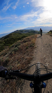
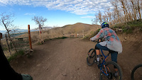
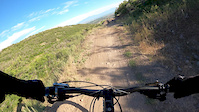
SaveCorner Canyon is the "Go To" riding area in South Salt Lake and for many riders it is worth the drive (or ride) from Utah County. It is a good mix of everything from beginner training trails in Little Valley to big table tops and wall rides in Maple Hollow. The Rush Downhill only trail and Anne's Trail are favorites for riders that like fast flow on any type of mountain bike. For a little more primitive and loose downhill there is the Jacobs Ladder Trail. The rest of the trails are mostly easy to intermediate smooth trails with the occasional sandy sections down below and hard clay pack up top.
The city of Draper has a trail closures and conditions map.
The city has big plans for this area and they continue to up their game with the recent addition of a jump track and cyclocross course just south of the Equestrian Center. Future plans include trail access from the south side of Traverse Ridge.
 google parking directions
 Activities Click to view
- Mountain Bike
147 trails
- E-Bike
136 trails
- Hike
140 trails
- Trail Running
136 trails
- Horse
10 trails
- Snowshoe
0 trails
Region Details
- 15
- 6
- 34
- 73
- 15
- 2
Region Status
Open as of Apr 20, 2021Local Trail Association
Stats
- Avg Trail Rating
- Trails (view details)
- 164
- Trails Mountain Bike
- 147
- Trails E-Bike
- 136
- Trails Hike
- 140
- Trails Trail Running
- 136
- Trails Horse
- 10
- Total Distance
- 115 miles
- Total Descent
- 21,625 ft
- Total Vertical
- 5,126 ft
- Highest Trailhead
- 9,478 ft
- Reports
- 8,704
- Photos
- 924
- Ridden Counter
- 197,999
Popular Corner Canyon Mountain Biking Trails
Corner Canyon Mountain Bike Routes
| title | rating | distance |
|---|---|---|
| The Real Mighty 5 | 28 miles | |
| Achtung Loop | 7 miles | |
| An Introduction to Corner Canyon | 3 miles | |
| Corner Canyon Cruise | 7 miles | |
| Upper Draper Loop | 8 miles | |
| Carpe Diem Loop | 7 miles | |
| Corner Canyon Classic | 8 miles | |
| Up Canyon Hollow Down Ghost Falls and Rattler Loop | 6 miles | |
| Tour de corner canyon | 24 miles | |
| Anns, Jacobs Ladder, & Rush Loop!!! | 11 miles |
Photos of Corner Canyon Mountain Bike
trail: Zooropa
250 |
Jun 8, 2018 @ 9:59pm
Jun 8, 2018
trail: Achtung Baby
284 |
Jun 7, 2018 @ 3:28pm
Jun 7, 2018
trail: Achtung Baby
236 |
Jun 7, 2018 @ 3:27pm
Jun 7, 2018
trail: Zooropa
243 |
Jun 1, 2018 @ 7:48pm
Jun 1, 2018
trail: Exit Stage Left (Rush)
381 |
Aug 11, 2017 @ 4:50pm
Aug 11, 2017
trail: Maple Hollow DH (Lower)
1,021 |
Aug 1, 2017 @ 6:51pm
Aug 1, 2017
trail: Maple Hollow DH (Upper)
1,021 |
Aug 1, 2017 @ 6:51pm
Aug 1, 2017
trail: Maple Hollow DH (Lower)
1,001 |
Jul 14, 2016 @ 4:28pm
Jul 14, 2016
trail: Exit Stage Left (Rush)
878 |
May 19, 2015 @ 8:27am
May 19, 2015Videos of Corner Canyon Mountain Bike
trail: Jacobs Ladder, Middle
15 |
May 31, 2022

trail: Levitate
80 |
Apr 9, 2022

trail: Levitate
|
Apr 9, 2022
trail: Levitate
292 |
May 4, 2021
trail: Limelight (Rush)
114 |
Mar 12, 2021
trail: Levitate
0:54 |
210 |
Jul 14, 2020
trail: Maple Hollow DH (Lower)
0:28 |
266 |
Jul 1, 2020

trail: Maple Hollow DH (Lower)
0:28 |
|
Jul 1, 2020
Current Trail Warnings
| status | trail | date | condition | user | info |
|---|---|---|---|---|---|
| Vertigo | Jul 1, 2022 @ 10:12am Jul 1, 2022 | Prevalent Mud | Orionbman123 | Lots of slick muddy spots | |
| Maple Hollow DH (Lower) | Jun 26, 2022 @ 7:00am Jun 26, 2022 | Dry | 801Ski-Free | Use caution!! There is a tree across the... |
Recent Trail Reports
| status | trail | date | condition | info | user |
|---|---|---|---|---|---|
| Zooropa | Jul 5, 2022 @ 8:49am 18 hours | Dry | Deez54 | ||
| Rush Flow | Jul 3, 2022 @ 8:55am 3 days | Very Dry | cfrogjump | ||
| Exit Stage Left (Rush) | Jul 3, 2022 @ 8:55am 3 days | Very Dry | cfrogjump | ||
| Rush Climb | Jul 3, 2022 @ 8:55am 3 days | Very Dry | cfrogjump | ||
| Canyon Hollow (Silica Pit) | Jul 3, 2022 @ 8:55am 3 days | Very Dry | cfrogjump | ||
| Potato Hill | Jul 3, 2022 @ 8:08am 3 days | Dry | therealkondor | ||
| Anns (East) | Jul 3, 2022 @ 8:08am 3 days | Very Dry | therealkondor | ||
| Brocks Point | Jul 3, 2022 @ 8:08am 3 days | Ideal | therealkondor | ||
| Ghost Falls | Jul 3, 2022 @ 8:08am 3 days | Dry | therealkondor | ||
| Ghost Falls North | Jul 3, 2022 @ 8:08am 3 days | Dry | therealkondor |
Activity Feed
| username | action | type | title | date | |
|---|---|---|---|---|---|
 | iagnewpcut | ridden | trail | Rattle and Hum and 5 more | Jul 5, 2022 @ 9:59pm 5 hours |
| TimothyHk3qWd | ridden | trail | Carpe Diem and 19 more | Jul 5, 2022 @ 7:00pm 8 hours |
| TimothyHk3qWd | comment | trail | Rattler | Jul 5, 2022 @ 6:52pm 8 hours |
| TimothyHk3qWd | vote | trail | Rattler | Jul 5, 2022 @ 6:51pm 8 hours |
| Lambert123 | ridden | trail | Anns Pointe and 46 more | Jul 5, 2022 @ 2:57pm 12 hours |
Recent Comments
| username | type | title | comment | date | |
|---|---|---|---|---|---|
| trail | I always passed this one up going down to... | Jul 5, 2022 @ 6:52pm 8 hours | ||
| trail | Sort of overgrown in some spots (very... | Jul 3, 2022 @ 4:07pm 2 days | ||
| trail | The uphil climb was annoying, most of the... | Jul 1, 2022 @ 6:22pm Jul 1, 2022 | ||
| trail | Entire thing is completely redone, and some... | Jul 1, 2022 @ 1:39pm Jul 1, 2022 | ||
| trail | I love this trail as it is, very different... | Jun 28, 2022 @ 5:40am Jun 28, 2022 |
Nearby Areas
| name | distance | ||||
|---|---|---|---|---|---|
| Traverse Mountain Trails | 2 | 7 | 2.7 km | ||
| Hidden Valley | 1 | 2 | 3.1 km | ||
| Lambert Park | 13 | 38 | 3 | 1 | 4.4 km |
| Dimple Dell | 7 | 1 | 4.4 km | ||
| Highland Hollow | 4 | 3 | 5 km |
Local Badges
-

Completionist1 awarded
National Scenic Trails & Official Routes
-
Bonneville Shoreline Trail
- Mountain Bike
- E-Bike
- Hike
- Trail Running
- Horse
- Snowshoe
- Nordic Ski

Bike & Skill Parks
| name | type | city | rating |
|---|---|---|---|
| Draper Cycle Park | skill park | Draper |
Local Products
Activity Type Stats
| activitytype | trails | distance | descent | descent distance | total vertical | rating | global rank | state rank | photos | reports | routes | ridelogs |
|---|---|---|---|---|---|---|---|---|---|---|---|---|
| Mountain Bike | 147 | 100 miles | 19,203 ft | 53 miles | 2,333 ft | #2 | #1 | 864 | 8,700 | 63 | 107,072 | |
| E-Bike | 136 | 97 miles | 18,802 ft | 52 miles | 2,333 ft | #1 | #1 | 4 | 8,566 | 8 | 2,973 | |
| Hike | 140 | 99 miles | 15,351 ft | 44 miles | 5,125 ft | #3 | #1 | 52 | 8,194 | 5 | 1,598 | |
| Trail Running | 136 | 93 miles | 14,685 ft | 43 miles | 2,333 ft | #3 | #1 | 4 | 8,193 | 10 | 2,269 | |
| Horse | 10 | 17 miles | 2,336 ft | 6 miles | 1,506 ft | #57 | #46 | 3,878 | 1 | 2 |
- By todd
 Trailforks & contributors
 - Admins: apply
- #4876 - 83,753 views
- corner canyon activity log | embed map of Corner Canyon mountain bike trails | corner canyon mountain biking points of interest
Downloading of trail gps tracks in kml & gpx formats is enabled for Corner Canyon.
You must login to download files.