close
Trail Conditions
- Unknown
- Snow Groomed
- Snow Packed
- Snow Covered
- Snow Cover Inadequate
- Freeze/thaw Cycle
- Icy
- Prevalent Mud
- Wet
- Variable
- Ideal
- Dry
- Very Dry
Trail Flow (Ridden Direction)
Trailforks scans users ridelogs to determine the most popular direction each trail is ridden. A good flowing trail network will have most trails flowing in a single direction according to their intension.
The colour categories are based on what percentage of riders are riding a trail in its intended direction.
The colour categories are based on what percentage of riders are riding a trail in its intended direction.
- > 96%
- > 90%
- > 80%
- > 70%
- > 50%
- < 50%
- bi-directional trail
- no data
Trail Last Ridden
Trailforks scans ridelogs to determine the last time a trail was ridden.
- < 2 days
- < 1 week
- < 2 weeks
- < 1 month
- < 6 months
- > 6 months
Trail Ridden Direction
The intended direction a trail should be ridden.
- Downhill Only
- Downhill Primary
- Both Directions
- Uphill Primary
- Uphill Only
- One Direction
Contribute Details
Colors indicate trail is missing specified detail.
- Description
- Photos
- Description & Photos
- Videos
Trail Popularity ?
Trailforks scans ridelogs to determine which trails are ridden the most in the last 9 months.
Trails are compared with nearby trails in the same city region with a possible 25 colour shades.
Think of this as a heatmap, more rides = more kinetic energy = warmer colors.
- most popular
- popular
- less popular
- not popular
ATV/ORV/OHV Filter
Max Vehicle Width
inches
Radar Time
x
Activity Recordings
Trailforks users anonymized public ridelogs from the past 6 months.
- mountain biking recent
- mountain biking (>6 month)
- hiking (1 year)
- moto (1 year)
Activity Recordings
Trailforks users anonymized public skilogs from the past 12 months.
- Downhill Ski
- Backcountry Ski
- Nordic Ski
Jump Magnitude Heatmap
Heatmap of where riders jump on trails. Zoom in to see individual jumps, click circles to view jump details.
Trails Deemphasized
Trails are shown in grey.
Only show trails with NO bikes.
Save the current map location and zoom level as your default home location whenever this page is loaded.
SavePopular Trail Networks
view all areas »
No description for Melbourne has been added yet!
Login or register to submit one.
Activities Click to view
- Mountain Bike
427 trails
- E-Bike
278 trails
- Hike
392 trails
- Trail Running
395 trails
Region Details
- 53
- 19
- 163
- 136
- 45
- 9
- 1
Region Status
Open as of Jun 10, 2022Stats
- Avg Trail Rating
- Trails (view details)
- 441
- Trails Mountain Bike
- 427
- Trails E-Bike
- 278
- Trails Hike
- 392
- Trails Trail Running
- 395
- Trails Horse
- 9
- Trails Dirtbike/Moto
- 9
- Trails ATV/ORV/OHV
- 7
- Trails Snowshoe
- 1
- Total Distance
- 725 miles
- Total Descent
- 38,401 ft
- Total Vertical
- 6,029 ft
- Highest Trailhead
- 6,030 ft
- Reports
- 2,674
- Photos
- 1,279
- Ridden Counter
- 96,797
Sub Regions
-
420 Acres
- 6
- 2
- 2
-
Frankston South
-
Greenvale
- 17
- 2
-
H.E. Parker Reserve
- 2
- 2
- 4
-
Long Forest Conservation Park
-
Maribyrnong river
- 11
- 3
-
Montrose Trails
- 9
- 3
- 3
-
N O R G E
- 3
- 26
- 7
-
Officer Scout Camp
-
Plenty Gorge
- 30
- 60
- 18
- 6
- 1
-
Quarry Park Mountain Bike Trails
- 2
- 2
-
RJ Hamer
-
Temple Park Reserve
- 1
- 1
- 1
-
Westgate Park
- 2
- 2
-
Yarra Bend Park
- 3
- 17
- 20
- 3
-
You Yangs
- 7
- 7
- 6
- 2
Popular Melbourne Mountain Biking Trails
Melbourne Mountain Bike Routes
| title | rating | distance |
|---|---|---|
| Kurrajong Loop | 11 miles | |
| Plenty Gorge quick & fun 15 | 9 miles | |
| Steele Creek XC loop. | 2 miles | |
| Melbournes best lanes (Coffee and Graffiti Tour) | 3 miles | |
| Tank to Tank | 3 miles | |
| PG 19km loop from tank carpark | 12 miles | |
| White Cow Gets Lost | 4 miles | |
| City Trails 2 Single Track | 50 miles | |
| Tour de YY | 24 miles | |
| gorge to bev | 21 miles |
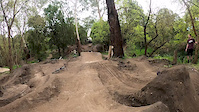
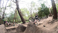
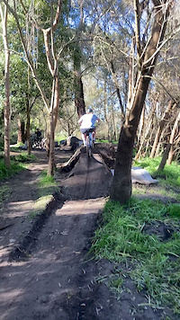
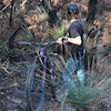
Photos of Melbourne Mountain Bike
trail: Peregrine Track
14 |
Jun 15, 2022 @ 3:13am
Jun 15, 2022
trail: Jeebus
13 |
Jun 10, 2022 @ 7:01pm
Jun 10, 2022
trail: Gorgeous LINK
12 |
Apr 30, 2022 @ 6:39pm
Apr 30, 2022
trail: Gorgeous LINK
7 |
Apr 30, 2022 @ 6:39pm
Apr 30, 2022
trail: Ozymandias
29 |
Apr 30, 2022 @ 6:37pm
Apr 30, 2022
trail: In The Dog
28 |
Apr 25, 2022 @ 4:46am
Apr 25, 2022
trail: In The Dog
16 |
Apr 25, 2022 @ 4:18am
Apr 25, 2022
trail: In The Dog
12 |
Apr 25, 2022 @ 4:17am
Apr 25, 2022Videos of Melbourne Mountain Bike
trail: Norris Descent
32 |
Apr 22, 2022
trail: Cressy Descent
80 |
Jul 23, 2021
trail: Turbulence
102 |
Jun 28, 2021

trail: Yarra River Trail
176 |
Oct 23, 2020
trail: Yarra River Trail
|
Oct 23, 2020
trail: Ryburne jumps
0:08 |
|
Sep 4, 2020
trail: Ryburne jumps
0:06 |
|
Sep 4, 2020
trail: Ryburne jumps
0:10 |
307 |
Sep 4, 2020
Current Trail Warnings
| status | trail | date | condition | user | info |
|---|---|---|---|---|---|
| Cressy Descent | Jun 28, 2022 @ 2:21am Jun 28, 2022 | Dry | JesseoLNlMI | Currently closed for repairs week of June... | |
| In The Dog | Jun 18, 2022 @ 7:22pm Jun 18, 2022 | Variable | Pauls35BHL | ||
| In the Dog Connector | Jun 18, 2022 @ 7:22pm Jun 18, 2022 | Variable | Pauls35BHL |
Recent Trail Reports
| status | trail | date | condition | info | user |
|---|---|---|---|---|---|
| Inner Loop | Jul 1, 2022 @ 9:52pm Jul 1, 2022 | Ideal | susmtb | ||
| Wilson Reserve Trail | Jun 25, 2022 @ 2:36pm Jun 25, 2022 | Wet | 251 | ||
| Wandering Wombat | Jun 18, 2022 @ 7:22pm Jun 18, 2022 | Variable | Pauls35BHL | ||
| Up Outta The River | Jun 18, 2022 @ 7:22pm Jun 18, 2022 | Variable | Pauls35BHL | ||
| Fire Road South Side to Plenty River | Jun 18, 2022 @ 7:22pm Jun 18, 2022 | Variable | Pauls35BHL | ||
| In The Dog - New Alignment 2022 | Jun 18, 2022 @ 7:22pm Jun 18, 2022 | Variable | Pauls35BHL | ||
| South Side Rocky Ridge Descent | Jun 18, 2022 @ 7:22pm Jun 18, 2022 | Variable | Pauls35BHL | ||
| Crop Circles | Jun 18, 2022 @ 7:22pm Jun 18, 2022 | Variable | Pauls35BHL | ||
| Am I Lost | Jun 18, 2022 @ 7:22pm Jun 18, 2022 | Variable | Pauls35BHL | ||
| Goat Track | Jun 18, 2022 @ 7:22pm Jun 18, 2022 | Variable | Pauls35BHL |
Activity Feed
| username | action | type | title | date | |
|---|---|---|---|---|---|
 | yliu | wishlist | region | Quarry Park Mountain Bike Trails | Jul 4, 2022 @ 10:42pm 1 day |
| Kmountain | ridden | trail | Main Yarra Trail | Jul 4, 2022 @ 3:48am 2 days |
 | Jackson234 | difficultyvote | trail | Cressy Descent | Jul 3, 2022 @ 6:05pm 2 days |
 | bikerjon123 | ridden | trail | Chainsaw alt and 8 more | Jul 3, 2022 @ 2:52pm 3 days |
| Kdiamond78 | add | karma | You Yangs | Jul 2, 2022 @ 8:28pm Jul 2, 2022 |
Recent Comments
| username | type | title | comment | date | |
|---|---|---|---|---|---|
| trail | Low branches | Jun 17, 2022 @ 11:27pm Jun 17, 2022 | ||
| trail | New section. Bit loose. Thanks to the trail... | May 1, 2022 @ 9:22pm May 1, 2022 | ||
| trail | Yeah i was on a hardtail and beginner lol, Nah... | Apr 10, 2022 @ 3:30am Apr 10, 2022 | ||
| trail | Difficult to ride up and would be dangerous... | Apr 9, 2022 @ 11:08pm Apr 9, 2022 | ||
| trail | This trail is walkers only, please don't ride here | Feb 26, 2022 @ 4:27am Feb 26, 2022 |
Local Badges
-

Big Ride 30k27,977 awarded -

10 Blue Trails1,096 awarded -

10 Black Trails634 awarded -

Epic Ride 50k10,653 awarded -

Climbing 10k Badge671 awarded -

10 Green Trails809 awarded
Bike & Skill Parks
| name | type | city | rating |
|---|---|---|---|
| 40 Acres Dirt Jumps | skill park | Melbourne | |
| Aberfeldie Jumps | skill park | Melbourne | |
| Altona Meadows Dirt Jumps | skill park | Melbourne | |
| Bayside Jumps | skill park | Melbourne | |
| Blackburn BMX Track | skill park | Melbourne |
Activity Type Stats
| activitytype | trails | distance | descent | descent distance | total vertical | rating | global rank | state rank | photos | reports | routes | ridelogs |
|---|---|---|---|---|---|---|---|---|---|---|---|---|
| Mountain Bike | 427 | 684 miles | 34,754 ft | 276 miles | 6,030 ft | #40 | #5 | 1,206 | 2,671 | 40 | 165,650 | |
| E-Bike | 278 | 590 miles | 24,662 ft | 234 miles | 6,030 ft | #30 | #5 | 57 | 2,441 | 7 | 2,997 | |
| Hike | 392 | 695 miles | 34,304 ft | 280 miles | 6,030 ft | #30 | #1 | 9 | 2,619 | 2 | 1,120 | |
| Trail Running | 395 | 697 miles | 34,528 ft | 281 miles | 6,030 ft | #30 | #1 | 6 | 2,628 | 7 | 3,152 | |
| Horse | 9 | 24 miles | 1,381 ft | 7 miles | 4,993 ft | 1 | 1,291 | 1 | ||||
| Dirtbike/Moto | 9 | 32 miles | 4,905 ft | 13 miles | 5,020 ft | 1,290 | 8 | |||||
| ATV/ORV/OHV | 7 | 20 miles | 2,566 ft | 6 miles | 4,465 ft | 1,290 | 7 | |||||
| Snowshoe | 1 | 10 miles | 210 ft | 4 miles | 72 ft | 2 | 1 |
- By hfilmer PGMTB & contributors
- Admins: Jake-Hannah, Addzz, MTBA, stuartrichardson, PGMTB
- #5313 - 45,258 views
- melbourne activity log | embed map of Melbourne mountain bike trails | melbourne mountain biking points of interest polygons
Downloading of trail gps tracks in kml & gpx formats is enabled for Melbourne.
You must login to download files.