close
Trail Conditions
- Unknown
- Snow Groomed
- Snow Packed
- Snow Covered
- Snow Cover Inadequate
- Freeze/thaw Cycle
- Icy
- Prevalent Mud
- Wet
- Variable
- Ideal
- Dry
- Very Dry
Trail Flow (Ridden Direction)
Trailforks scans users ridelogs to determine the most popular direction each trail is ridden. A good flowing trail network will have most trails flowing in a single direction according to their intension.
The colour categories are based on what percentage of riders are riding a trail in its intended direction.
The colour categories are based on what percentage of riders are riding a trail in its intended direction.
- > 96%
- > 90%
- > 80%
- > 70%
- > 50%
- < 50%
- bi-directional trail
- no data
Trail Last Ridden
Trailforks scans ridelogs to determine the last time a trail was ridden.
- < 2 days
- < 1 week
- < 2 weeks
- < 1 month
- < 6 months
- > 6 months
Trail Ridden Direction
The intended direction a trail should be ridden.
- Downhill Only
- Downhill Primary
- Both Directions
- Uphill Primary
- Uphill Only
- One Direction
Contribute Details
Colors indicate trail is missing specified detail.
- Description
- Photos
- Description & Photos
- Videos
Trail Popularity ?
Trailforks scans ridelogs to determine which trails are ridden the most in the last 9 months.
Trails are compared with nearby trails in the same city region with a possible 25 colour shades.
Think of this as a heatmap, more rides = more kinetic energy = warmer colors.
- most popular
- popular
- less popular
- not popular
ATV/ORV/OHV Filter
Max Vehicle Width
inches
Radar Time
x
Activity Recordings
Trailforks users anonymized public ridelogs from the past 6 months.
- mountain biking recent
- mountain biking (>6 month)
- hiking (1 year)
- moto (1 year)
Activity Recordings
Trailforks users anonymized public skilogs from the past 12 months.
- Downhill Ski
- Backcountry Ski
- Nordic Ski
Jump Magnitude Heatmap
Heatmap of where riders jump on trails. Zoom in to see individual jumps, click circles to view jump details.
Trails Deemphasized
Trails are shown in grey.
Only show trails with NO bikes.
Save the current map location and zoom level as your default home location whenever this page is loaded.
Save
No description for Gold Coast has been added yet!
Login or register to submit one.
Region Supporters & Maintainers
![]()
Outlook Riders AllianceSponsor![]()
Nerang Trail Care AllianceSponsor
Activities Click to view
- Mountain Bike
126 trails
- E-Bike
122 trails
- Hike
71 trails
- Trail Running
71 trails
- Horse
24 trails
Region Details
- 38
- 21
- 39
- 23
- 3
- 2
Region Status
Open as of May 3, 2022Stats
- Avg Trail Rating
- Trails (view details)
- 135
- Trails Mountain Bike
- 127
- Trails E-Bike
- 122
- Trails Hike
- 71
- Trails Trail Running
- 71
- Trails Horse
- 24
- Total Distance
- 171 miles
- Total Descent
- 31,867 ft
- Total Vertical
- 3,343 ft
- Highest Trailhead
- 3,351 ft
- Reports
- 1,452
- Photos
- 928
- Ridden Counter
- 69,492
 Articles
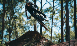
Video: Aden de Jager Self Shuttles at Boomerang Farm Bike Park
May 20, 2020 from pinkbike.com
No uplift necessary for the former supercross racer on the Gold Coast.
Sub Regions
-
Bonogin
- 1
- 1
-
Boomerang Farm Bike Park
- 2
- 4
- 6
- 3
- 2
-
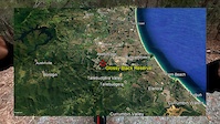
Glossy Black Reserve
- 5
- 3
-
Hinze Dam
- 2
- 2
-
Illinbah
- 1
-
Nerang National Park
- 9
- 30
- 12
-
Old Tambo
- 3
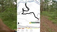
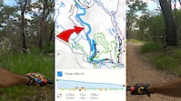
Popular Gold Coast Mountain Biking Trails
Gold Coast Mountain Bike Routes
| title | rating | distance |
|---|---|---|
| 3 Hills Mongrels Petes | 5 miles | |
| Casuarina Petes Up and Down Comm Games 1 | 5 miles | |
| Fox Superflow | 6 miles | |
| 2021 Planned burn inner 15km loop | 9 miles | |
| Lost World Loop | 14 miles | |
| Friday Arvo Solo - 40 | 26 miles | |
| Qld Enduro Series Rd1 Stage 3. DH2. | 2,848 ft | |
| Lost world | 14 miles | |
| Qld Enduro Series Rd1 Stage 4 Rodney's. | 3,550 ft | |
| Goanna Loop Clockwise | 5 miles |
Photos of Gold Coast Mountain Bike
trail: Pandora
19 |
May 1, 2022 @ 3:10am
May 1, 2022
trail: Old Tambo Downhill
8 |
Apr 14, 2022 @ 1:00am
Apr 14, 2022
trail: Old Tambo Downhill
7 |
Apr 14, 2022 @ 12:59am
Apr 14, 2022
trail: Old Tambo Downhill
8 |
Apr 14, 2022 @ 12:59am
Apr 14, 2022
trail: Old Tambo Downhill
7 |
Apr 14, 2022 @ 12:59am
Apr 14, 2022
trail: Explosions
100 |
May 17, 2018 @ 5:50pm
May 17, 2018
trail: Norco Flow
293 |
Dec 9, 2008 @ 8:10pm
Dec 9, 2008
trail: Norco Flow
310 | | 1 comments
Jul 24, 2008 @ 4:26am
Jul 24, 2008Videos of Gold Coast Mountain Bike
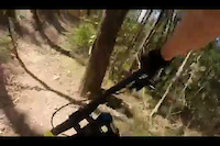
trail: Big Line
7 |
Jul 4, 2022
trail: Hateful8
23 |
May 12, 2022
trail: Three Hills
30 |
Apr 29, 2022
trail: Casuarina Grove Circuit
27 |
Apr 29, 2022
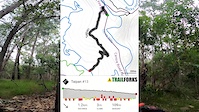
trail: Taipan
105 |
Apr 17, 2022
trail: Drop Bear
|
Oct 1, 2021

trail: Old Tambo Downhill
154 |
Dec 2, 2020
trail: Cockys Climb
166 |
Oct 29, 2020
Current Trail Warnings
| status | trail | date | condition | user | info |
|---|---|---|---|---|---|
| Super Loop | Jul 4, 2022 @ 6:44pm 1 day | Dry | Sonofhans NTCA | take care after planned burn | |
| Never Ending Story | Jul 4, 2022 @ 6:42pm 1 day | Dry | Sonofhans NTCA | bridge out after burn, take care | |
| Catch Me If You Can | Jun 28, 2022 @ 4:20pm Jun 28, 2022 | Dry | turtlelikeythebikey | Bridge collapsed. No signage of trail... |
Recent Trail Reports
| status | trail | date | condition | info | user |
|---|---|---|---|---|---|
| Skrood | Jul 4, 2022 @ 6:48pm 1 day | Dry | Sonofhans NTCA | ||
| N.E.S Super Loop Connection | Jul 4, 2022 @ 6:47pm 1 day | Dry | Sonofhans NTCA | ||
| GG's Track | Jul 4, 2022 @ 6:46pm 1 day | Dry | Sonofhans NTCA | ||
| Raptor | Jul 4, 2022 @ 6:46pm 1 day | Dry | Sonofhans NTCA | ||
| Lost World | Jul 4, 2022 @ 6:46pm 1 day | Dry | Sonofhans NTCA | ||
| Pandora | Jul 4, 2022 @ 6:45pm 1 day | Dry | Sonofhans NTCA | ||
| Avatar | Jul 4, 2022 @ 6:45pm 1 day | Dry | Sonofhans NTCA | ||
| Jumpin' Ant Hill | Jul 2, 2022 @ 12:01am Jul 2, 2022 | Wet | noxie | ||
| Taipan | Jun 21, 2022 @ 4:52pm Jun 21, 2022 | Variable | Sonofhans NTCA | ||
| GG's Link | Jun 21, 2022 @ 4:51pm Jun 21, 2022 | Dry | Sonofhans NTCA |
Activity Feed
| username | action | type | title | date | |
|---|---|---|---|---|---|
 | Sonofhans | comment | report | Catch Me If You Can | Jul 4, 2022 @ 6:44pm 1 day |
| Sonofhans | add | report | Never Ending Story and 8 more | Jul 4, 2022 @ 6:42pm 1 day |
 | CoreyDMTB | ridden | trail | Taipan and 6 more | Jul 4, 2022 @ 2:27am 2 days |
| noxie | add | report | Jumpin' Ant Hill | Jul 2, 2022 @ 12:01am Jul 2, 2022 |
| mr-t-80 | ridden | trail | B+Bs and 3 more | Jul 1, 2022 @ 2:09pm Jul 1, 2022 |
Recent Comments
| username | type | title | comment | date | |
|---|---|---|---|---|---|
| report | This looks like Never Ending Story rather than... | Jul 4, 2022 @ 6:44pm 1 day | ||
| trail | not sure why it and the velodrome were added... | Jun 9, 2022 @ 4:44am Jun 9, 2022 | ||
 | trail | Why is this road bike track described as a Mtb... | Jun 7, 2022 @ 3:07pm Jun 7, 2022 | ||
| report | Tree cleared | May 30, 2022 @ 10:40pm May 30, 2022 | ||
| trail | This is a road bike route not a trail | May 28, 2022 @ 3:07pm May 28, 2022 |
Local Badges
-

10 Green Trails527 awarded -

Completionist0 awarded -

Big Ride 30k11,744 awarded -

10 Black Trails408 awarded -

10 Blue Trails750 awarded -

Climbing 10k Badge341 awarded
Activity Type Stats
| activitytype | trails | distance | descent | descent distance | total vertical | rating | global rank | state rank | photos | reports | routes | ridelogs |
|---|---|---|---|---|---|---|---|---|---|---|---|---|
| Mountain Bike | 126 | 144 miles | 24,941 ft | 56 miles | 1,827 ft | #66 | #7 | 910 | 1,452 | 49 | 72,719 | |
| E-Bike | 122 | 146 miles | 24,659 ft | 55 miles | 1,827 ft | #21 | #3 | 4 | 1,233 | 11 | 3,760 | |
| Hike | 71 | 109 miles | 19,938 ft | 42 miles | 3,343 ft | #524 | #33 | 13 | 1,131 | 2 | 1,603 | |
| Trail Running | 71 | 109 miles | 19,938 ft | 42 miles | 3,343 ft | #526 | #32 | 1 | 1,132 | 9 | 1,727 | |
| Horse | 24 | 26 miles | 5,351 ft | 13 miles | 755 ft | #22 | 553 | 10 |
- By aaroncob
 & contributors
 - Admins: Jake-Hannah, Addzz, MTBA
- #13301 - 23,778 views
- gold coast activity log | embed map of Gold Coast mountain bike trails | gold coast mountain biking points of interest
Downloading of trail gps tracks in kml & gpx formats is enabled for Gold Coast.
You must login to download files.