close
Trail Conditions
- Unknown
- Snow Groomed
- Snow Packed
- Snow Covered
- Snow Cover Inadequate
- Freeze/thaw Cycle
- Icy
- Prevalent Mud
- Wet
- Variable
- Ideal
- Dry
- Very Dry
Trail Flow (Ridden Direction)
Trailforks scans users ridelogs to determine the most popular direction each trail is ridden. A good flowing trail network will have most trails flowing in a single direction according to their intension.
The colour categories are based on what percentage of riders are riding a trail in its intended direction.
The colour categories are based on what percentage of riders are riding a trail in its intended direction.
- > 96%
- > 90%
- > 80%
- > 70%
- > 50%
- < 50%
- bi-directional trail
- no data
Trail Last Ridden
Trailforks scans ridelogs to determine the last time a trail was ridden.
- < 2 days
- < 1 week
- < 2 weeks
- < 1 month
- < 6 months
- > 6 months
Trail Ridden Direction
The intended direction a trail should be ridden.
- Downhill Only
- Downhill Primary
- Both Directions
- Uphill Primary
- Uphill Only
- One Direction
Contribute Details
Colors indicate trail is missing specified detail.
- Description
- Photos
- Description & Photos
- Videos
Trail Popularity ?
Trailforks scans ridelogs to determine which trails are ridden the most in the last 9 months.
Trails are compared with nearby trails in the same city region with a possible 25 colour shades.
Think of this as a heatmap, more rides = more kinetic energy = warmer colors.
- most popular
- popular
- less popular
- not popular
ATV/ORV/OHV Filter
Max Vehicle Width
inches
Radar Time
x
Activity Recordings
Trailforks users anonymized public ridelogs from the past 6 months.
- mountain biking recent
- mountain biking (>6 month)
- hiking (1 year)
- moto (1 year)
Activity Recordings
Trailforks users anonymized public skilogs from the past 12 months.
- Downhill Ski
- Backcountry Ski
- Nordic Ski
Jump Magnitude Heatmap
Heatmap of where riders jump on trails. Zoom in to see individual jumps, click circles to view jump details.
Trails Deemphasized
Trails are shown in grey.
Only show trails with NO bikes.
Save the current map location and zoom level as your default home location whenever this page is loaded.
Save
No description for Wyong has been added yet!
Login or register to submit one.
Activities Click to view
- Mountain Bike
82 trails
- E-Bike
37 trails
- Hike
34 trails
- Trail Running
34 trails
Region Details
- 12
- 5
- 18
- 28
- 13
- 1
Region Status
Open as of Jun 28, 2022Stats
- Avg Trail Rating
- Trails (view details)
- 81
- Trails Mountain Bike
- 82
- Trails E-Bike
- 37
- Trails Hike
- 34
- Trails Trail Running
- 34
- Trails Horse
- 7
- Trails Dirtbike/Moto
- 7
- Trails Observed Trials
- 1
- Trails ATV/ORV/OHV
- 4
- Total Distance
- 71 miles
- Total Descent
- 7,291 ft
- Total Vertical
- 1,040 ft
- Highest Trailhead
- 1,044 ft
- Reports
- 1,430
- Photos
- 144
- Ridden Counter
- 43,898
Sub Regions
-
Ourimbah MTB Park
- 2
- 15
- 26
- 13
-
Trailshare
- 2
- 1
- 2
- 1
-
Wyong Hill Reserve
- 1
Popular Wyong Mountain Biking Trails
Wyong Mountain Bike Routes
| title | rating | distance |
|---|---|---|
| Lyrebird Run - Full XC Loop | 6 miles | |
| Back in Black - DH Mainline | 1 mile | |
| Family Loop | 4,977 ft | |
| Gravitron - GE Mainline | 1 mile | |
| CCMTB GE 2022 - Round 1 race | 10 miles | |
| Convict 100 (44km) race | 27 miles | |
| race | 11 miles | |
| race | 6 miles | |
| race | 11 miles | |
| race | 6 miles |
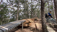
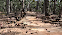
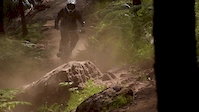
Photos of Wyong Mountain Bike
trail: Graveyards
1 |
Jun 29, 2022 @ 5:51am
Jun 29, 2022
trail: Moto-4WD Trail Hill Climb
0 |
Jun 29, 2022 @ 5:22am
Jun 29, 2022
trail: Moto-4WD Trail Hill Climb
12 |
Jun 29, 2022 @ 5:22am
Jun 29, 2022
trail: Intermediate Jump line
21 |
Jun 14, 2022 @ 11:30pm
Jun 14, 2022
trail: Intermediate Jump line
34 |
Jun 14, 2022 @ 11:30pm
Jun 14, 2022
trail: Trailhead climb
96 |
May 14, 2021 @ 6:14pm
May 14, 2021
trail: Amaroo
266 |
Mar 13, 2021 @ 4:07pm
Mar 13, 2021
trail: Centrelink
171 |
Jul 7, 2020 @ 2:04am
Jul 7, 2020Videos of Wyong Mountain Bike

trail: Schladming
76 |
Jul 7, 2021
trail: BK Express
|
Nov 5, 2020
trail: BK Express
|
Nov 5, 2020
trail: Rollercoaster
0:14 |
2324 |
Mar 3, 2015
trail: Rollercoaster
0:10 |
747 |
Jul 10, 2010

trail: Double Down
4:24 |
361 |
Aug 9, 2021 , Wyong
4:24 |
83 |
Aug 9, 2021

4:24 |
56 |
Aug 7, 2021
Current Trail Warnings
| status | trail | date | condition | user | info |
|---|---|---|---|---|---|
| Magic Carpet | Jun 13, 2022 @ 2:45am Jun 13, 2022 | Wet | Camgilly | Closed pending repair work required at... |
Recent Trail Reports
| status | trail | date | condition | info | user |
|---|---|---|---|---|---|
| Long Meadows | Jun 28, 2022 @ 2:53am Jun 28, 2022 | Variable | spikenet | ||
| Graveyards | Jun 24, 2022 @ 5:59pm Jun 24, 2022 | Variable | Camgilly | ||
| Five Ways climb | Jun 20, 2022 @ 4:09am Jun 20, 2022 | Variable | Bachudo CCMTB | ||
| Flow connector | Jun 20, 2022 @ 4:09am Jun 20, 2022 | Variable | Bachudo CCMTB | ||
| Lower All Mountain | Jun 20, 2022 @ 4:09am Jun 20, 2022 | Variable | Bachudo CCMTB | ||
| Red Hill Road | Jun 20, 2022 @ 4:09am Jun 20, 2022 | Variable | Bachudo CCMTB | ||
| Rock N Roll | Jun 20, 2022 @ 4:09am Jun 20, 2022 | Variable | Bachudo CCMTB | ||
| Rollercoaster Exit | Jun 20, 2022 @ 4:09am Jun 20, 2022 | Variable | Bachudo CCMTB | ||
| Rollercoaster short cut | Jun 20, 2022 @ 4:09am Jun 20, 2022 | Variable | Bachudo CCMTB | ||
| Tower climb | Jun 20, 2022 @ 4:09am Jun 20, 2022 | Variable | Bachudo CCMTB |
Activity Feed
| username | action | type | title | date | |
|---|---|---|---|---|---|
 | Camgilly | add | trail | Jelly Legs Bypass | Jul 3, 2022 @ 5:39am 3 days |
| Camgilly | add | photo | in My City and 2 more | Jun 29, 2022 @ 5:22am Jun 29, 2022 |
| Camgilly | update | trail | Moto-4WD Trail Hill Climb | Jun 29, 2022 @ 5:16am Jun 29, 2022 |
 | spikenet | update | polygon | Self Shuttle Drop Off | Jun 29, 2022 @ 3:29am Jun 29, 2022 |
| spikenet | add | report | Long Meadows | Jun 28, 2022 @ 2:53am Jun 28, 2022 |
Recent Comments
| username | type | title | comment | date | |
|---|---|---|---|---|---|
 | trail | Is this place actually open/closed? Looks... | Jan 19, 2022 @ 5:17pm Jan 19, 2022 | ||
| trail | Is there a build date on this? | Jul 27, 2021 @ 7:03pm Jul 27, 2021 | ||
| trail | Fast hard and dh But if ur pedaling to the top... | Jul 9, 2021 @ 11:57pm Jul 9, 2021 | ||
| trail | Yeah hard to get going but a pretty good trail... | Jul 9, 2021 @ 11:55pm Jul 9, 2021 | ||
| trail | I found it weird at first but each run seems... | Sep 2, 2020 @ 12:56am Sep 2, 2020 |
Local Badges
-

10 Blue Trails606 awarded -

Big Ride 30k634 awarded -

Completionist2 awarded -

Epic Ride 50k231 awarded -

Epic Ride Climb 2k70 awarded -

Climbing 10k Badge47 awarded
Bike & Skill Parks
| name | type | city | rating |
|---|---|---|---|
| Ourimbah MTB Park | bike park | Wyong | |
| Trailshare | bike park | Wyong | |
| Long Jetty BMX Track | skill park | Wyong |
Activity Type Stats
| activitytype | trails | distance | descent | descent distance | total vertical | rating | global rank | state rank | photos | reports | routes | ridelogs |
|---|---|---|---|---|---|---|---|---|---|---|---|---|
| Mountain Bike | 82 | 71 miles | 7,290 ft | 32 miles | 1,040 ft | #138 | #16 | 144 | 1,430 | 17 | 9,267 | |
| E-Bike | 37 | 58 miles | 4,157 ft | 24 miles | 1,040 ft | #239 | #34 | 1,229 | 10 | 840 | ||
| Hike | 34 | 56 miles | 3,832 ft | 23 miles | 1,040 ft | #726 | #42 | 1,304 | 49 | |||
| Trail Running | 34 | 55 miles | 3,881 ft | 23 miles | 1,040 ft | #759 | #47 | 1,304 | 12 | |||
| Horse | 7 | 6 miles | 840 ft | 3 miles | 597 ft | 360 | ||||||
| Dirtbike/Moto | 7 | 6 miles | 840 ft | 3 miles | 597 ft | 360 | 24 | |||||
| Observed Trials | 1 | 1 | 1 | |||||||||
| ATV/ORV/OHV | 4 | 2 miles | 10 ft | 446 ft | 548 ft | 360 |
- By brenthillier
 NSMBA TRAILFORKS & contributors
 - Admins: MTBA, stuartrichardson, CCMTB
- #3937 - 4,702 views
- wyong activity log | embed map of Wyong mountain bike trails | wyong mountain biking points of interest polygons
Downloading of trail gps tracks in kml & gpx formats is enabled for Wyong.
You must login to download files.