close
Trail Conditions
- Unknown
- Snow Groomed
- Snow Packed
- Snow Covered
- Snow Cover Inadequate
- Freeze/thaw Cycle
- Icy
- Prevalent Mud
- Wet
- Variable
- Ideal
- Dry
- Very Dry
Trail Flow (Ridden Direction)
Trailforks scans users ridelogs to determine the most popular direction each trail is ridden. A good flowing trail network will have most trails flowing in a single direction according to their intension.
The colour categories are based on what percentage of riders are riding a trail in its intended direction.
The colour categories are based on what percentage of riders are riding a trail in its intended direction.
- > 96%
- > 90%
- > 80%
- > 70%
- > 50%
- < 50%
- bi-directional trail
- no data
Trail Last Ridden
Trailforks scans ridelogs to determine the last time a trail was ridden.
- < 2 days
- < 1 week
- < 2 weeks
- < 1 month
- < 6 months
- > 6 months
Trail Ridden Direction
The intended direction a trail should be ridden.
- Downhill Only
- Downhill Primary
- Both Directions
- Uphill Primary
- Uphill Only
- One Direction
Contribute Details
Colors indicate trail is missing specified detail.
- Description
- Photos
- Description & Photos
- Videos
Trail Popularity ?
Trailforks scans ridelogs to determine which trails are ridden the most in the last 9 months.
Trails are compared with nearby trails in the same city region with a possible 25 colour shades.
Think of this as a heatmap, more rides = more kinetic energy = warmer colors.
- most popular
- popular
- less popular
- not popular
ATV/ORV/OHV Filter
Max Vehicle Width
inches
Radar Time
x
Activity Recordings
Trailforks users anonymized public ridelogs from the past 6 months.
- mountain biking recent
- mountain biking (>6 month)
- hiking (1 year)
- moto (1 year)
Activity Recordings
Trailforks users anonymized public skilogs from the past 12 months.
- Downhill Ski
- Backcountry Ski
- Nordic Ski
Jump Magnitude Heatmap
Heatmap of where riders jump on trails. Zoom in to see individual jumps, click circles to view jump details.
Trails Deemphasized
Trails are shown in grey.
Only show trails with NO bikes.
Save the current map location and zoom level as your default home location whenever this page is loaded.
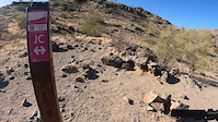
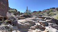
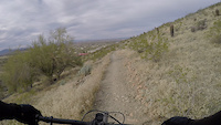
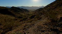
SaveAt more than 16,000 acres, South Mountain Park/Preserve is one of the largest municipally managed parks in the nation and consists of three mountain ranges - the Ma Ha Tauk, Gila and Guadalupe. The park boasts more than 100 miles of trails for hiking, horseback riding and mountain biking. Additionally, the roadways throughout the park are a favorite for bicyclists.
Dobbins Lookout, at 2,330 feet, is the highest point in the park that is available to the public. Accessed by both hiking trails and Summit Rd., the lookout is popular with tourists and locals alike, who want to get an unobstructed panoramic view of the Valley.
Note: The park's scenic roadways are shared by motor vehicles, bikers and hikers. Due to the many blind corners, narrow sections and treacherous drop-offs, extreme caution should be maintained and adherence to the speed limit followed.
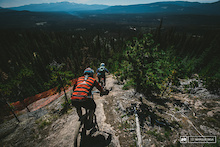
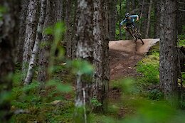
Primary Trail Type: All-Mountain & Downhill
eBikes Allowed:
Yes
Shuttleable: YES
Land Status: City Managed
Land Manager: City of Phoenix Parks and Recreation
 google parking directions
 Region Supporters & Maintainers
![City of Phoenix Parks and Recreation]()
City of Phoenix Parks and RecreationMaintainer
Activities Click to view
- Mountain Bike
98 trails
- E-Bike
98 trails
- Hike
98 trails
- Trail Running
98 trails
- Horse
52 trails
Region Details
- 6
- 3
- 9
- 42
- 22
- 16
Region Status
Open as of 2 daysStats
- Avg Trail Rating
- Trails (view details)
- 98
- Trails Mountain Bike
- 98
- Trails E-Bike
- 98
- Trails Hike
- 98
- Trails Trail Running
- 98
- Trails Horse
- 52
- Total Distance
- 133 miles
- Total Descent
- 26,756 ft
- Total Vertical
- 1,414 ft
- Highest Trailhead
- 2,515 ft
- Reports
- 1,782
- Photos
- 546
- Ridden Counter
- 49,834
 Articles

Arizona's 5 Most Popular Trail Networks According to Trailforks Data
Oct 19, 2021 from pinkbike.com
The American Southwest is chock full of bucket list locales, and perhaps no single southwestern state is home to more of them than Arizona.
Popular South Mountain Preserve Mountain Biking Trails
South Mountain Preserve Mountain Bike Routes
| title | rating | distance |
|---|---|---|
| Pima Lot Javalina DH Loop | 5 miles | |
| SoMo Rollingpin | 10 miles | |
| Naty-Eliminator-DC | 25 miles | |
| Warpaint Helipad Loop | 8 miles | |
| Corona de Helipad | 8 miles | |
| National Loop | 12 miles | |
| Desert Classic to Helipad | 15 miles | |
| SoMo: DC Beginner/Intermediate Loop | 10 miles | |
| HELIPAD SO MO | 10 miles | |
| Corona de Javelina | 15 miles |
Photos of South Mountain Preserve Mountain Bike
trail: Helipad
132 |
Apr 3, 2020 @ 9:02pm
Apr 3, 2020
trail: National
1,950 | | 2 comments
Aug 11, 2017 @ 5:24am
Aug 11, 2017
trail: National
1,418 |
Aug 8, 2017 @ 12:08pm
Aug 8, 2017
trail: Javelina Canyon
454 |
Jun 25, 2017 @ 6:42pm
Jun 25, 2017
trail: Javelina Canyon
432 |
Jun 25, 2017 @ 6:42pm
Jun 25, 2017
trail: National
1,010 |
Feb 9, 2017 @ 1:05pm
Feb 9, 2017
trail: Javelina Canyon
790 |
Feb 9, 2015 @ 10:05am
Feb 9, 2015
trail: TNT
890 | | 1 comments
Apr 1, 2014 @ 11:49am
Apr 1, 2014Videos of South Mountain Preserve Mountain Bike
trail: Javelina Canyon
67 |
Apr 11, 2022
trail: 32nd Street
44 |
Apr 7, 2022
trail: National
89 |
Feb 20, 2022
trail: National
56 |
Feb 20, 2022
trail: Ma-Ha-Tuak Perimeter Trail
53 |
Jan 21, 2022

trail: National
69 |
Sep 23, 2021

trail: National
45 |
Sep 23, 2021
trail: Gila
43 |
Mar 9, 2021
Recent Trail Reports
| status | trail | date | condition | info | user |
|---|---|---|---|---|---|
| Telegraph Pass | Jul 4, 2022 @ 5:34am 2 days | Ideal | A3Rider | ||
| Old Man | Jul 4, 2022 @ 5:34am 2 days | Ideal | A3Rider | ||
| DC Ray Conn | Jul 4, 2022 @ 5:34am 2 days | Ideal | A3Rider | ||
| Desert Classic | Jul 3, 2022 @ 7:42am 3 days | Dry | TylerkQN0CO | ||
| Secret | Jul 3, 2022 @ 7:42am 3 days | Dry | TylerkQN0CO | ||
| Corona Conn | Jun 29, 2022 @ 5:13am Jun 29, 2022 | Ideal | A3Rider | ||
| Goat | Jun 13, 2022 @ 5:26am Jun 13, 2022 | Very Dry | Lucki13 | ||
| Guadalupe Perimeter Trail | Jun 13, 2022 @ 5:26am Jun 13, 2022 | Very Dry | Lucki13 | ||
| Pima Canyon Dirt Road | Jun 11, 2022 @ 5:54am Jun 11, 2022 | Dry | hawk124 | ||
| BPC to Loop East | Jun 11, 2022 @ 5:54am Jun 11, 2022 | Dry | hawk124 |
Activity Feed
| username | action | type | title | date | |
|---|---|---|---|---|---|
 | A3Rider | add | report | Telegraph Pass and 2 more | Jul 5, 2022 @ 9:43am 17 hours |
| xrotaryguy | wishlist | trail | Pima Canyon Dirt Road | Jul 4, 2022 @ 8:24am 2 days |
| xrotaryguy | wishlist | region | South Mountain Preserve | Jul 3, 2022 @ 5:57pm 2 days |
| Lubglass | vote | trail | 32nd Street | Jul 3, 2022 @ 3:54pm 2 days |
| xrotaryguy | wishlist | trail | Pima Canyon Dirt Road | Jul 3, 2022 @ 11:21am 3 days |
Recent Comments
| username | type | title | comment | date | |
|---|---|---|---|---|---|
 | trail | Needs a re-route, some of this isn’t really... | Jun 20, 2022 @ 8:18am Jun 20, 2022 | ||
 | trail | An unusual trail with a beautiful view of the... | Jun 14, 2022 @ 12:09pm Jun 14, 2022 | ||
| trail | Don’t move the rocks! Leave it raw! | Jun 5, 2022 @ 9:11pm Jun 5, 2022 | ||
 | trail | Nice work uploading this! Trail is now closed... | May 11, 2022 @ 10:15pm May 11, 2022 | ||
| trail | Simple trail. Lots of walkers. Good for gravel... | May 10, 2022 @ 8:56pm May 10, 2022 |
Nearby Areas
| name | distance | ||||
|---|---|---|---|---|---|
| Rio Salado Habitat Restoration Area | 6 km | ||||
| Papago Park | 27 | 8 | 10.9 km | ||
| Echo Canyon Recreation Area | 14.4 km | ||||
| Phoenix Mountain Preserve | 18 | 50 | 21 | 2 | 16.5 km |
| Estrella Mountain Regional Park | 4 | 14 | 1 | 17.6 km |
Local Badges
-

Completionist0 awarded
Pinkbike Articles
Oct 19, 2021
 Arizona's 5 Most Popular Trail Networks According to Trailforks Data
The American Southwest is chock full of bucket list locales, and perhaps no single southwestern state is home to more of them than Arizona.
Oct 12, 2016
 BC Bucket List: Northern BC
With the Yukon to the North, Alaska to the West and Alberta on the East, Northern BC's vast wilderness is larger than California or Japan, and...
Jun 9, 2021
 Local Flavours: Northern British Columbia Road Trip - Part 1
Everything you need to know about riding in Terrace, Smithers and Burns Lake.
Activity Type Stats
| activitytype | trails | distance | descent | descent distance | total vertical | rating | global rank | state rank | photos | reports | routes | ridelogs |
|---|---|---|---|---|---|---|---|---|---|---|---|---|
| Mountain Bike | 98 | 133 miles | 26,755 ft | 63 miles | 1,414 ft | #45 | #19 | 510 | 1,781 | 36 | 81,625 | |
| E-Bike | 98 | 133 miles | 26,755 ft | 63 miles | 1,414 ft | #19 | #6 | 3 | 1,581 | 6 | 2,279 | |
| Hike | 98 | 133 miles | 26,755 ft | 63 miles | 1,414 ft | #27 | #15 | 28 | 1,774 | 19 | 3,253 | |
| Trail Running | 98 | 133 miles | 26,755 ft | 63 miles | 1,414 ft | #26 | #14 | 2 | 1,774 | 4 | 2,156 | |
| Horse | 52 | 72 miles | 14,213 ft | 36 miles | 1,391 ft | #2 | #2 | 718 | 1 |
- By todd
 Trailforks & contributors
 - Admins: GROAZ, RangerRiske
- #4990 - 70,940 views
- south mountain preserve activity log | embed map of South Mountain Preserve mountain bike trails | south mountain preserve mountain biking points of interest
Downloading of trail gps tracks in kml & gpx formats is enabled for South Mountain Preserve.
You must login to download files.