close
Trail Conditions
- Unknown
- Snow Groomed
- Snow Packed
- Snow Covered
- Snow Cover Inadequate
- Freeze/thaw Cycle
- Icy
- Prevalent Mud
- Wet
- Variable
- Ideal
- Dry
- Very Dry
Trail Flow (Ridden Direction)
Trailforks scans users ridelogs to determine the most popular direction each trail is ridden. A good flowing trail network will have most trails flowing in a single direction according to their intension.
The colour categories are based on what percentage of riders are riding a trail in its intended direction.
The colour categories are based on what percentage of riders are riding a trail in its intended direction.
- > 96%
- > 90%
- > 80%
- > 70%
- > 50%
- < 50%
- bi-directional trail
- no data
Trail Last Ridden
Trailforks scans ridelogs to determine the last time a trail was ridden.
- < 2 days
- < 1 week
- < 2 weeks
- < 1 month
- < 6 months
- > 6 months
Trail Ridden Direction
The intended direction a trail should be ridden.
- Downhill Only
- Downhill Primary
- Both Directions
- Uphill Primary
- Uphill Only
- One Direction
Contribute Details
Colors indicate trail is missing specified detail.
- Description
- Photos
- Description & Photos
- Videos
Trail Popularity ?
Trailforks scans ridelogs to determine which trails are ridden the most in the last 9 months.
Trails are compared with nearby trails in the same city region with a possible 25 colour shades.
Think of this as a heatmap, more rides = more kinetic energy = warmer colors.
- most popular
- popular
- less popular
- not popular
ATV/ORV/OHV Filter
Max Vehicle Width
inches
Radar Time
x
Activity Recordings
Trailforks users anonymized public ridelogs from the past 6 months.
- mountain biking recent
- mountain biking (>6 month)
- hiking (1 year)
- moto (1 year)
Activity Recordings
Trailforks users anonymized public skilogs from the past 12 months.
- Downhill Ski
- Backcountry Ski
- Nordic Ski
Jump Magnitude Heatmap
Heatmap of where riders jump on trails. Zoom in to see individual jumps, click circles to view jump details.
Trails Deemphasized
Trails are shown in grey.
Only show trails with NO bikes.
Save the current map location and zoom level as your default home location whenever this page is loaded.
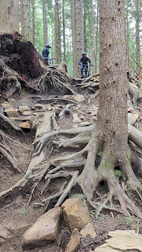
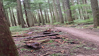
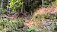
SaveTiger Mountain is one of Seattle's most popular mountain biking destinations. The East Tiger Summit, Preston Railroad Grade, Iverson (Fat Hand), Silent Swamp, Fully Rigid, Joy Ride, Predator, Off-the-Grid, Preston BailOut Radness, The Legend, Master Link, Quick Link, Easy Tiger and Northwest Timber Trails are all open to bicycles. Starting in 2014, trails will not be subject to the past Oct 15 to Apr 15 seasonal closures. However, all trails are still subject to closures depending on trail and weather conditions (check for updates on this page and here). There are many miles of logging roads that are open all year long.
source: Evergreen MTB
Primary Trail Type: All-Mountain & Downhill
eBikes Allowed:
No
Land Status: State Forest
Land Manager: Washington State DNR
 google parking directions
 Region Supporters & Maintainers
![Washington State DNR]()
Washington State DNRMaintainer
Activities Click to view
- Mountain Bike
50 trails
- Hike
103 trails
- Trail Running
103 trails
Region Details
- 21
- 6
- 12
- 8
- 3
Region Status
Open as of Jun 12, 2022Local Trail Association
Stats
- Avg Trail Rating
- Trails (view details)
- 111
- Trails Mountain Bike
- 50
- Trails E-Bike
- 4
- Trails Hike
- 103
- Trails Trail Running
- 103
- Trails Horse
- 1
- Total Distance
- 122 miles
- Total Descent
- 30,795 ft
- Total Vertical
- 2,818 ft
- Highest Trailhead
- 3,002 ft
- Reports
- 3,194
- Photos
- 799
- Ridden Counter
- 60,787
Popular Tiger Mountain State Forest Trails
Mountain Bike Routes
| title | rating | distance |
|---|---|---|
| OTG to Ebad and out | 10 miles | |
| 2022 CDC: Tiger Mt Enduro - Lite | 7 miles | |
| Tiger: The Milk Run | 10 miles | |
| Side Hustle Loop | 9 miles | |
| Tiger: Defanged - The Intermediate Loop | 13 miles | |
| 2022 CDC: Tiger Mt Enduro - Novice | 9 miles | |
| Mirrormont Long Route | 16 miles | |
| Tiger: Big Burly Hat Trick | 21 miles | |
| Tiger: Summit+Predator Figure 8 Power Loop | 10 miles | |
| FirstTiger | 13 miles |
Photos of Tiger Mountain State Forest Mountain Bike
trail: East Bound And Down
449 |
Sep 12, 2018 @ 7:05pm
Sep 12, 2018
trail: East Bound And Down
632 |
Sep 12, 2018 @ 7:03pm
Sep 12, 2018
trail: East Bound And Down
423 |
Sep 12, 2018 @ 7:02pm
Sep 12, 2018
trail: NOTG
1,109 |
Sep 4, 2018 @ 2:05am
Sep 4, 2018
trail: Master Link
752 |
Apr 13, 2017 @ 10:04pm
Apr 13, 2017
trail: Master Link
984 |
Apr 13, 2017 @ 10:04pm
Apr 13, 2017
trail: Predator
3,126 |
Oct 13, 2015 @ 8:07pm
Oct 13, 2015
trail: Predator
1,206 |
Oct 13, 2015 @ 8:06pm
Oct 13, 2015Videos of Tiger Mountain State Forest Mountain Bike


Recent Trail Reports
| status | trail | date | condition | info | user |
|---|---|---|---|---|---|
| Side Hustle | Jul 5, 2022 @ 3:57pm 11 hours | Ideal | Svampesvamp | ||
| Super-T | Jul 5, 2022 @ 2:32pm 12 hours | Ideal | Alspins | ||
| Silent Swamp | Jul 5, 2022 @ 2:30pm 12 hours | Variable | Alspins | ||
| Preston Railroad | Jul 4, 2022 @ 10:35pm 1 day | Wet | yamabrap | ||
| Iverson | Jul 4, 2022 @ 9:38pm 1 day | Wet | IndianapolisJones | ||
| Atlas | Jul 4, 2022 @ 11:19am 2 days | Prevalent Mud | jmahler TRAILFORKS | ||
| Joy Ride | Jul 4, 2022 @ 9:50am 2 days | Ideal | Gcbrandt | ||
| Predator | Jul 1, 2022 @ 11:03am Jul 1, 2022 | Ideal | Tgj88 | ||
| Close Encounters | Jun 30, 2022 @ 9:30am Jun 30, 2022 | Dry | Hannah91 | ||
| NOTG | Jun 25, 2022 @ 11:30am Jun 25, 2022 | Ideal | dgbiker1 |
Activity Feed
| username | action | type | title | date | |
|---|---|---|---|---|---|
 | IsaacQOOf4L | ridden | trail | Master Link and 9 more | Jul 5, 2022 @ 5:45pm 9 hours |
| IsaacQOOf4L | vote | trail | Master Link and 11 more | Jul 5, 2022 @ 5:45pm 9 hours |
| mennotele | vote | trail | NOTG | Jul 5, 2022 @ 5:35pm 9 hours |
| Svampesvamp | add | report | Side Hustle | Jul 5, 2022 @ 3:57pm 11 hours |
| Alspins | ridden | trail | Silent Swamp and 1 more | Jul 5, 2022 @ 2:31pm 12 hours |
Recent Comments
| username | type | title | comment | date | |
|---|---|---|---|---|---|
| trail | Great trail. Very fast and float. No mandatory... | Jul 5, 2022 @ 1:55pm 13 hours | ||
 | trail | Make other trails like this please! | Jul 4, 2022 @ 11:08pm 1 day | ||
| trail | "Spicy blue"/easy black are about my limit as... | Jul 3, 2022 @ 9:39am 3 days | ||
| trail | Rode this today, definitely more difficult... | Jul 2, 2022 @ 11:42am Jul 2, 2022 | ||
| trail | EC | Jul 1, 2022 @ 8:40pm Jul 1, 2022 |
Nearby Areas
| name | distance | ||||
|---|---|---|---|---|---|
| Taylor Mountain | 11 | 3.6 km | |||
| Snoqualmie Ridge | 5 | 4 km | |||
| Raging River State Forest | 4 | 5 | 2 | 2 | 4.5 km |
| Grand Ridge Park | 13 | 12 | 2 | 5 km | |
| Rattlesnake Mountain Scenic Area | 6.5 km |
Local Badges
-

Tiger Tamed5 awarded -

Completionist7 awarded
Local Products
Activity Type Stats
| activitytype | trails | distance | descent | descent distance | total vertical | rating | global rank | state rank | photos | reports | routes | ridelogs |
|---|---|---|---|---|---|---|---|---|---|---|---|---|
| Mountain Bike | 50 | 62 miles | 17,520 ft | 34 miles | 2,329 ft | #39 | #16 | 788 | 3,175 | 70 | 35,217 | |
| E-Bike | 4 | 8 miles | 1,352 ft | 4 miles | 1,037 ft | 1,914 | 1 | 488 | ||||
| Hike | 103 | 114 miles | 26,181 ft | 52 miles | 2,818 ft | #38 | #20 | 11 | 2,775 | 12 | 632 | |
| Trail Running | 103 | 114 miles | 26,181 ft | 52 miles | 2,818 ft | #37 | #19 | 2,775 | 12 | 603 | ||
| Horse | 1 | 1 mile | 125 ft | 2,129 ft | 272 ft | 956 | 2 |
- By jebike & contributors
- Admins: apply
- #5475 - 117,761 views
- tiger mountain state forest activity log | embed map of Tiger Mountain State Forest mountain bike trails | tiger mountain state forest mountain biking points of interest
Downloading of trail gps tracks in kml & gpx formats is enabled for Tiger Mountain State Forest.
You must login to download files.