close
Trail Conditions
- Unknown
- Snow Groomed
- Snow Packed
- Snow Covered
- Snow Cover Inadequate
- Freeze/thaw Cycle
- Icy
- Prevalent Mud
- Wet
- Variable
- Ideal
- Dry
- Very Dry
Trail Flow (Ridden Direction)
Trailforks scans users ridelogs to determine the most popular direction each trail is ridden. A good flowing trail network will have most trails flowing in a single direction according to their intension.
The colour categories are based on what percentage of riders are riding a trail in its intended direction.
The colour categories are based on what percentage of riders are riding a trail in its intended direction.
- > 96%
- > 90%
- > 80%
- > 70%
- > 50%
- < 50%
- bi-directional trail
- no data
Trail Last Ridden
Trailforks scans ridelogs to determine the last time a trail was ridden.
- < 2 days
- < 1 week
- < 2 weeks
- < 1 month
- < 6 months
- > 6 months
Trail Ridden Direction
The intended direction a trail should be ridden.
- Downhill Only
- Downhill Primary
- Both Directions
- Uphill Primary
- Uphill Only
- One Direction
Contribute Details
Colors indicate trail is missing specified detail.
- Description
- Photos
- Description & Photos
- Videos
Trail Popularity ?
Trailforks scans ridelogs to determine which trails are ridden the most in the last 9 months.
Trails are compared with nearby trails in the same city region with a possible 25 colour shades.
Think of this as a heatmap, more rides = more kinetic energy = warmer colors.
- most popular
- popular
- less popular
- not popular
ATV/ORV/OHV Filter
Max Vehicle Width
inches
Radar Time
x
Activity Recordings
Trailforks users anonymized public ridelogs from the past 6 months.
- mountain biking recent
- mountain biking (>6 month)
- hiking (1 year)
- moto (1 year)
Activity Recordings
Trailforks users anonymized public skilogs from the past 12 months.
- Downhill Ski
- Backcountry Ski
- Nordic Ski
Jump Magnitude Heatmap
Heatmap of where riders jump on trails. Zoom in to see individual jumps, click circles to view jump details.
Trails Deemphasized
Trails are shown in grey.
Only show trails with NO bikes.
Save the current map location and zoom level as your default home location whenever this page is loaded.
SaveThis region is Unsanctioned, Ride at your own Risk!
The region of trails surrounding Yarra Bend Park and the Yarra Boulevard. These are unsanctioned trails, and thus have no real trail builders, maintainers, or other likewise associated personnel.
Primary Trail Type: Cross-Country
Land Status: Conservation Reserve
Activities Click to view
- Mountain Bike
45 trails
- E-Bike
21 trails
- Hike
35 trails
- Trail Running
36 trails
Region Details
- 1
- 3
- 17
- 20
- 3
Region Status
Caution as of Feb 17, 2022Stats
- Avg Trail Rating
- Trails (view details)
- 44
- Trails Mountain Bike
- 45
- Trails E-Bike
- 21
- Trails Hike
- 35
- Trails Trail Running
- 36
- Trails Horse
- 2
- Trails Snowshoe
- 1
- Total Distance
- 33 miles
- Total Descent
- 2,321 ft
- Total Vertical
- 384 ft
- Highest Trailhead
- 415 ft
- Reports
- 138
- Photos
- 76
- Ridden Counter
- 7,824
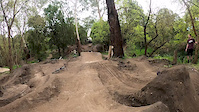
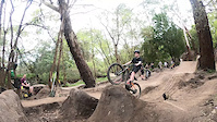
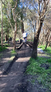
Popular Yarra Bend Park Mountain Biking Trails
Yarra Bend Park Mountain Bike Routes
| title | rating | distance |
|---|---|---|
| Merri Christmas | 4 miles |
Photos of Yarra Bend Park Mountain Bike
trail: Wild Horses
35 |
Mar 3, 2022 @ 3:20am
Mar 3, 2022
trail: Merri Creek Singletrack
41 |
Oct 8, 2021 @ 3:13am
Oct 8, 2021
trail: Edgars Creek
21 |
Oct 8, 2021 @ 3:13am
Oct 8, 2021
trail: Edgars Creek
43 |
Oct 8, 2021 @ 3:12am
Oct 8, 2021
trail: Shred Gnar's Creek
43 |
Oct 8, 2021 @ 3:12am
Oct 8, 2021
trail: Merri Creek Singletrack
83 |
Sep 11, 2021 @ 8:27pm
Sep 11, 2021
trail: Merri Creek Singletrack
83 |
Sep 9, 2021 @ 2:54pm
Sep 9, 2021
trail: Merri Creek Singletrack
76 |
Sep 9, 2021 @ 2:53pm
Sep 9, 2021
trail: Merri Creek Singletrack
79 |
Sep 9, 2021 @ 2:53pm
Sep 9, 2021Videos of Yarra Bend Park Mountain Bike

trail: Norris Descent
32 |
Apr 22, 2022
trail: Ryburne jumps
0:08 |
|
Sep 4, 2020
trail: Ryburne jumps
0:06 |
|
Sep 4, 2020
trail: Ryburne jumps
0:10 |
307 |
Sep 4, 2020

trail: Pipes to Bats
13:18 |
1131 |
Sep 27, 2019 , Melbourne
Recent Trail Reports
| status | trail | date | condition | info | user |
|---|---|---|---|---|---|
| Wilson Reserve Trail | Jun 25, 2022 @ 2:36pm Jun 25, 2022 | Wet | 251 | ||
| Norris Descent | May 14, 2022 @ 5:22pm May 14, 2022 | Variable | metranterc | ||
| Goat Track | May 14, 2022 @ 5:22pm May 14, 2022 | Variable | metranterc | ||
| Golf Course Loop | May 14, 2022 @ 5:22pm May 14, 2022 | Variable | metranterc | ||
| The Haymaker | Apr 27, 2022 @ 1:59am Apr 27, 2022 | Ideal | BeatrixKiddo | ||
| Merri Creek Singletrack | Apr 20, 2022 @ 4:52pm Apr 20, 2022 | Variable | cogs19 | ||
| Ivanhoe Golf Course MTB Track 1 | Mar 18, 2022 @ 3:49pm Mar 18, 2022 | Variable | sorrison | ||
| Rehab Track | Feb 17, 2022 @ 10:44pm Feb 17, 2022 | Dry | toddcycles | ||
| Pipes to Bats | Jan 30, 2022 @ 2:40am Jan 30, 2022 | Dry | sorrison | ||
| Main Yarra Trail | Dec 28, 2021 @ 10:59am Dec 28, 2021 | Dry | Maclainemajor |
Activity Feed
| username | action | type | title | date | |
|---|---|---|---|---|---|
 | Kmountain | ridden | trail | Main Yarra Trail | Jul 4, 2022 @ 3:48am 2 days |
| 251 | add | report | Wilson Reserve Trail | Jun 25, 2022 @ 10:22pm Jun 25, 2022 |
 | jigsaw314 | ridden | trail | Norris Descent | Jun 22, 2022 @ 3:44am Jun 22, 2022 |
| metranterc | comment | trail | Deep Rock Singletrack | Jun 17, 2022 @ 11:27pm Jun 17, 2022 |
| metranterc | wishlist | trail | Golf Course Loop and 2 more | Jun 15, 2022 @ 3:12am Jun 15, 2022 |
Recent Comments
| username | type | title | comment | date | |
|---|---|---|---|---|---|
| trail | Low branches | Jun 17, 2022 @ 11:27pm Jun 17, 2022 | ||
| trail | This trail is walkers only, please don't ride here | Feb 26, 2022 @ 4:27am Feb 26, 2022 | ||
| trail | Good trail, technical, edge of a cliff. Some... | Feb 8, 2022 @ 4:46pm Feb 8, 2022 | ||
| trail | The Eastern side of the creek is a calm gravel... | Apr 7, 2021 @ 7:41pm Apr 7, 2021 | ||
| trail | Lots of sketchy spots. Bricks, scrap metal,... | Apr 7, 2021 @ 7:31pm Apr 7, 2021 |
Nearby Areas
| name | distance | ||||
|---|---|---|---|---|---|
| Westgate Park | 2 | 6.5 km | |||
| Quarry Park Mountain Bike Trails | 2 | 2 | 6.7 km | ||
| Maribyrnong river | 11 | 3 | 6.7 km | ||
| Candlebark Park | 13 | 9 | 1 | 1 | 7.5 km |
| Sweeney's jump | 1 | 1 | 8.8 km |
Local Badges
-

Completionist0 awarded
Bike & Skill Parks
| name | type | city | rating |
|---|---|---|---|
| Yarra Boulevard Skills Park | skill park | Melbourne |
Activity Type Stats
| activitytype | trails | distance | descent | descent distance | total vertical | rating | global rank | state rank | photos | reports | routes | ridelogs |
|---|---|---|---|---|---|---|---|---|---|---|---|---|
| Mountain Bike | 45 | 33 miles | 2,323 ft | 13 miles | 384 ft | #1,215 | #99 | 73 | 138 | 1 | 34,302 | |
| E-Bike | 21 | 22 miles | 1,250 ft | 8 miles | 220 ft | #1,515 | #131 | 103 | 1 | 213 | ||
| Hike | 35 | 31 miles | 1,962 ft | 11 miles | 384 ft | #1,055 | #68 | 3 | 126 | 63 | ||
| Trail Running | 36 | 32 miles | 1,975 ft | 11 miles | 384 ft | #1,039 | #72 | 132 | 665 | |||
| Horse | 2 | 11 miles | 312 ft | 4 miles | 144 ft | 19 | ||||||
| Snowshoe | 1 | 10 miles | 210 ft | 4 miles | 72 ft | 2 |
- By CalW & contributors
- Admins: MTBA, stuartrichardson, PGMTB
- #18240 - 20,966 views
- yarra bend park activity log | embed map of Yarra Bend Park mountain bike trails | yarra bend park mountain biking points of interest
Downloading of trail gps tracks in kml & gpx formats is enabled for Yarra Bend Park.
You must login to download files.