close
Trail Conditions
- Unknown
- Snow Groomed
- Snow Packed
- Snow Covered
- Snow Cover Inadequate
- Freeze/thaw Cycle
- Icy
- Prevalent Mud
- Wet
- Variable
- Ideal
- Dry
- Very Dry
Trail Flow (Ridden Direction)
Trailforks scans users ridelogs to determine the most popular direction each trail is ridden. A good flowing trail network will have most trails flowing in a single direction according to their intension.
The colour categories are based on what percentage of riders are riding a trail in its intended direction.
The colour categories are based on what percentage of riders are riding a trail in its intended direction.
- > 96%
- > 90%
- > 80%
- > 70%
- > 50%
- < 50%
- bi-directional trail
- no data
Trail Last Ridden
Trailforks scans ridelogs to determine the last time a trail was ridden.
- < 2 days
- < 1 week
- < 2 weeks
- < 1 month
- < 6 months
- > 6 months
Trail Ridden Direction
The intended direction a trail should be ridden.
- Downhill Only
- Downhill Primary
- Both Directions
- Uphill Primary
- Uphill Only
- One Direction
Contribute Details
Colors indicate trail is missing specified detail.
- Description
- Photos
- Description & Photos
- Videos
Trail Popularity ?
Trailforks scans ridelogs to determine which trails are ridden the most in the last 9 months.
Trails are compared with nearby trails in the same city region with a possible 25 colour shades.
Think of this as a heatmap, more rides = more kinetic energy = warmer colors.
- most popular
- popular
- less popular
- not popular
ATV/ORV/OHV Filter
Max Vehicle Width
inches
Radar Time
x
Activity Recordings
Trailforks users anonymized public ridelogs from the past 6 months.
- mountain biking recent
- mountain biking (>6 month)
- hiking (1 year)
- moto (1 year)
Activity Recordings
Trailforks users anonymized public skilogs from the past 12 months.
- Downhill Ski
- Backcountry Ski
- Nordic Ski
Jump Magnitude Heatmap
Heatmap of where riders jump on trails. Zoom in to see individual jumps, click circles to view jump details.
Trails Deemphasized
Trails are shown in grey.
Only show trails with NO bikes.
Save the current map location and zoom level as your default home location whenever this page is loaded.
Save
No description for Bonaire has been added yet!
Login or register to submit one.
Region Details
- 2
- 6
- 1
Stats
- Avg Trail Rating
- Trails (view details)
- 9
- Trails Mountain Bike
- 9
- Trails Hike
- 9
- Trails Trail Running
- 9
- Total Distance
- 16 miles
- Total Descent
- 1,062 ft
- Total Vertical
- 372 ft
- Highest Trailhead
- 442 ft
- Reports
- 3
- Photos
- 17
- Ridden Counter
- 46
Sub Regions
- Kralendijk (9)
Popular Bonaire Mountain Biking Trails
| status | title | difficulty | rating |
|---|---|---|---|
| Karpata Kralendijk | |||
| Top of Terrace / Seru Largu Kralendijk | |||
| Lower Karpata Service Road Kralendijk | |||
| The Hell (Lower Section) Kralendijk | |||
| Altamira Unjo Kralendijk | |||
| The Hell Kralendijk | |||
| Upper Karpata Service Road Kralendijk | |||
| Santa Barbara / Seru largu Kralendijk | |||
| Wayaka Kralendijk |
Photos of Bonaire Mountain Bike
trail: The Hell (Lower Section)
36 |
Dec 24, 2019 @ 7:38am
Dec 24, 2019
trail: The Hell (Lower Section)
36 |
Dec 24, 2019 @ 7:38am
Dec 24, 2019
trail: The Hell (Lower Section)
62 |
Dec 24, 2019 @ 7:38am
Dec 24, 2019Videos of Bonaire Mountain Bike


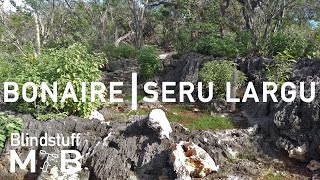
trail: Top of Terrace / Seru Largu
571 |
Jan 20, 2017 , Kralendijk
youtuber
![Mountain Biking Bonaire - Seru Largu]()

trail: Santa Barbara / Seru largu
660 |
Jan 20, 2017 , Kralendijk

Recent Trail Reports
| status | trail | date | condition | info | user |
|---|---|---|---|---|---|
| Santa Barbara / Seru largu Kralendijk | Dec 27, 2019 @ 6:07am Dec 27, 2019 | Ideal | Ruud-de-Jong | ||
| The Hell Kralendijk | Dec 24, 2019 @ 7:36am Dec 24, 2019 | Dry | Ruud-de-Jong | ||
| Karpata Kralendijk | Dec 23, 2019 @ 5:56am Dec 23, 2019 | Ideal | Ruud-de-Jong |
Recent Comments
| username | type | title | comment | date | |
|---|---|---|---|---|---|
 | trail | Beautiful decent from the seru largu. Great... | Jan 22, 2017 @ 2:06pm Jan 22, 2017 | ||
| trail | Very nice single track to the direction of... | Jan 22, 2017 @ 1:58pm Jan 22, 2017 |
Activity Type Stats
| activitytype | trails | distance | descent | descent distance | total vertical | rating | global rank | state rank | photos | reports | routes | ridelogs |
|---|---|---|---|---|---|---|---|---|---|---|---|---|
| Mountain Bike | 9 | 16 miles | 1,063 ft | 4 miles | 371 ft | #93 | 17 | 3 | 143 | |||
| Hike | 9 | 16 miles | 1,063 ft | 4 miles | 371 ft | #83 | 3 | 1 | ||||
| Trail Running | 9 | 16 miles | 1,063 ft | 4 miles | 371 ft | #84 | 3 | 3 |
- By blindstuff
 & contributors
 - Admins: apply
- #17363 - 6,351 views
- bonaire activity log | embed map of Bonaire mountain bike trails |
-
- subscribe
- 3d map
Downloading of trail gps tracks in kml & gpx formats is enabled for Bonaire.
You must login to download files.