5.1 miles
Distance
620 ft
Climb
-487 ft
Descent
00:51:11
Avg time
High Climber Details
-
Activities
- Mountain Bike
- Hike
- Trail Running
-
Riding AreaTofte
, Minnesota -
Difficulty Rating
-
Voted DifficultyBlue (4 votes)
-
Trail TypeSingletrack
-
Bike TypeAM, Fat
-
DirectionBoth Directions
-
Climb DifficultyGreen
-
Physical RatingEasy
-
Trail VisibilityAlways easy to follow
-
Dogs AllowedYes
-
TTFs on TrailBerm, Bridge, Drop, Jump, Gap Jump, Rock Face, Rock Garden
-
Global Ranking
-
Local Popularity75 in Mountain Biking [+]
- 5 in Trail Running
- 90 in Hiking
-
Year Opened2020
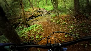
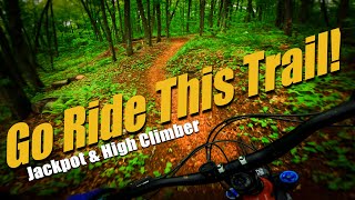
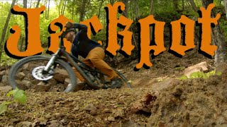
High Climber runs from Skihill Rd at Lutsen to the Onion River road. the trail continues as Jackpot trial on the other side of Onion River road, for a total distance between trailheads of about 15 miles.
This side is slightly easier than the Jackpot side: the rock gardens and armored sections a fewer, and smoother.
Access Info
Drive up Ski Hill road in Lutsen, past the ski lifts until the road turns to gravel. Park here. Follow the rough gravel road onwards, and follow the signs for Highclimber MTB trail. Do not start on the Superior Hiking trail.
Local Trail Association
-

-

-
Please consider joining or donating to the local trail association to supportdonate to earn trail karma!
trail development & maintenance.
Traditionally Indigenous Territory
More Stats for High Climber mountain bike trail trail
-
Altitude change134 ft
-
Altitude min1,309 ft
-
Altitude max1,641 ft
-
Altitude start1,313 ft
-
Altitude end1,447 ft
-
Grade0.5%
-
Grade max-46%
-
Grade min26.7%
-
Distance climb2 miles
-
Distance down2 miles
-
Distance flat1 mile
-
Avg time00:51:11
-
Avg reverse time00:48:10
- view trail stats
close
Trail Conditions
- Unknown
- Snow Groomed
- Snow Packed
- Snow Covered
- Snow Cover Inadequate
- Freeze/thaw Cycle
- Icy
- Prevalent Mud
- Wet
- Variable
- Ideal
- Dry
- Very Dry
Trail Flow (Ridden Direction)
Trailforks scans users ridelogs to determine the most popular direction each trail is ridden. A good flowing trail network will have most trails flowing in a single direction according to their intension.
The colour categories are based on what percentage of riders are riding a trail in its intended direction.
The colour categories are based on what percentage of riders are riding a trail in its intended direction.
- > 96%
- > 90%
- > 80%
- > 70%
- > 50%
- < 50%
- bi-directional trail
- no data
Trail Last Ridden
Trailforks scans ridelogs to determine the last time a trail was ridden.
- < 2 days
- < 1 week
- < 2 weeks
- < 1 month
- < 6 months
- > 6 months
Trail Ridden Direction
The intended direction a trail should be ridden.
- Downhill Only
- Downhill Primary
- Both Directions
- Uphill Primary
- Uphill Only
- One Direction
Contribute Details
Colors indicate trail is missing specified detail.
- Description
- Photos
- Description & Photos
- Videos
Trail Popularity ?
Trailforks scans ridelogs to determine which trails are ridden the most in the last 9 months.
Trails are compared with nearby trails in the same city region with a possible 25 colour shades.
Think of this as a heatmap, more rides = more kinetic energy = warmer colors.
- most popular
- popular
- less popular
- not popular
ATV/ORV/OHV Filter
Max Vehicle Width
inches
Radar Time
x
Activity Recordings
Trailforks users anonymized public ridelogs from the past 6 months.
- mountain biking recent
- mountain biking (>6 month)
- hiking (1 year)
- moto (1 year)
Activity Recordings
Trailforks users anonymized public skilogs from the past 12 months.
- Downhill Ski
- Backcountry Ski
- Nordic Ski
Jump Magnitude Heatmap
Heatmap of where riders jump on trails. Zoom in to see individual jumps, click circles to view jump details.
Trails Deemphasized
Trails are shown in grey.
Only show trails with NO bikes.
Save the current map location and zoom level as your default home location whenever this page is loaded.
Save
Directions to high-climber trailhead
(47.667410, -90.724470)
update trails status or condition
High Climber Trail Reports
view all reports »
Recent Ridelog Activity on Trail
Past Week
- 8 rides
- 18 miles avg distance
6 Months
- 40 rides
- 17 miles avg distance
All
- 179 rides
Photos
more »
Routes with this trail
Videos
more »
Nearby Trails
- Ullr Loop 1,060 ft
- Nct/sht - Lutsen Mountain Recreation Area To Caribou Trail 1,060 ft
- Sht - Mystery Mountain Campsite Access Trail 1,801 ft
- Sht - Cook County Road 5 Access Trail 2,293 ft
- Log Chute 2,415 ft
- embed High Climber trail on your website
- By nedersotan
 & contributors
 - #317654 - 2,575 views
- subscribe
- login to download gpx or kml files.