5,267 ft
Distance
412 ft
Climb
-29 ft
Descent
00:11:24
Avg time
Chutes Details
-
Activities
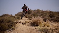
- Mountain Bike
- Hike
- Trail Running
- Horse
-
Riding AreaSantiago Oaks
Orange, California -
Difficulty Rating
-
Trail TypeSingletrack
-
Bike TypeAM, XC
-
DirectionUphill PrimaryPopular direction shown
-
Climb DifficultyBlack Diamond
-
Physical RatingModerate
-
SeasonYear Round
-
Dogs AllowedYes
-
Global Ranking
-
Local Popularity100 in Mountain Biking [+]
- 100 in Trail Running
- 90 in Hiking
- 5 in Horseback
Trail typically used to climb up the Barham Ridge.
Access Info
When starting the climb turn left at the split because Chutes Ridgeline or the primary downhill trail is on the right.
Local Trail Association
-

-
Please consider joining or donating to the local trail association to supportdonate to earn trail karma!
trail development & maintenance.
More Stats for Chutes mountain bike trail trail
-
Altitude change383 ft
-
Altitude min542 ft
-
Altitude max925 ft
-
Altitude start542 ft
-
Altitude end925 ft
-
Grade7.276%
-
Grade max-21.765%
-
Grade min22.742%
-
Distance climb4,399 ft
-
Distance down544 ft
-
Distance flat324 ft
-
Avg time00:11:24
-
Avg reverse time00:09:07
- view trail stats
close
Trail Conditions
- Unknown
- Snow Groomed
- Snow Packed
- Snow Covered
- Snow Cover Inadequate
- Freeze/thaw Cycle
- Icy
- Prevalent Mud
- Wet
- Variable
- Ideal
- Dry
- Very Dry
Trail Flow (Ridden Direction)
Trailforks scans users ridelogs to determine the most popular direction each trail is ridden. A good flowing trail network will have most trails flowing in a single direction according to their intension.
The colour categories are based on what percentage of riders are riding a trail in its intended direction.
The colour categories are based on what percentage of riders are riding a trail in its intended direction.
- > 96%
- > 90%
- > 80%
- > 70%
- > 50%
- < 50%
- bi-directional trail
- no data
Trail Last Ridden
Trailforks scans ridelogs to determine the last time a trail was ridden.
- < 2 days
- < 1 week
- < 2 weeks
- < 1 month
- < 6 months
- > 6 months
Trail Ridden Direction
The intended direction a trail should be ridden.
- Downhill Only
- Downhill Primary
- Both Directions
- Uphill Primary
- Uphill Only
- One Direction
Contribute Details
Colors indicate trail is missing specified detail.
- Description
- Photos
- Description & Photos
- Videos
Trail Popularity ?
Trailforks scans ridelogs to determine which trails are ridden the most in the last 9 months.
Trails are compared with nearby trails in the same city region with a possible 25 colour shades.
Think of this as a heatmap, more rides = more kinetic energy = warmer colors.
- most popular
- popular
- less popular
- not popular
ATV/ORV/OHV Filter
Max Vehicle Width
inches
Radar Time
x
Activity Recordings
Trailforks users anonymized public ridelogs from the past 6 months.
- mountain biking recent
- mountain biking (>6 month)
- hiking (1 year)
- moto (1 year)
Activity Recordings
Trailforks users anonymized public skilogs from the past 12 months.
- Downhill Ski
- Backcountry Ski
- Nordic Ski
Jump Magnitude Heatmap
Heatmap of where riders jump on trails. Zoom in to see individual jumps, click circles to view jump details.
Trails Deemphasized
Trails are shown in grey.
Only show trails with NO bikes.
Save the current map location and zoom level as your default home location whenever this page is loaded.
Save
Directions to chutes-7461 trailhead
(33.809880, -117.758810)
update trails status or condition
Chutes Trail Reports
view all reports »
Recent Ridelog Activity on Trail
Past Week
- 53 rides
- 9 miles avg distance
6 Months
- 1,626 rides
- 10 miles avg distance
All
- 14,408 rides

Photos
more »
Routes with this trail
more »
Videos
more »


Nearby Trails
- Road Runner Loop 653 ft
- Barham Ridge St (south) 1,362 ft
- Singletrack Mania 2,595 ft
- True Egret 2,776 ft
- Blair Witch 4,091 ft
- embed Chutes trail on your website
- By Desertrat3511 & contributors
- #7461 - 4,203 views
- subscribe
- login to download gpx or kml files.