1.2 miles
Distance
-1,016 ft
Descent
00:08:10
Avg time
10 Ply Details
-
Activities
- Mountain Bike
-
Riding AreaSnow Summit Bike Park
Big Bear, California -
Difficulty Rating
-
Voted DifficultyDouble Black Diamond (1 vote)
-
Trail TypeSingletrack
-
Bike TypeDH, AM
-
DirectionDownhill OnlyPopular direction shown
-
Physical RatingHard
-
SeasonMay-Oct
-
Dogs AllowedYes
-
eBike Allowed
-
TTFs on TrailBerm, Drop, Jump, Gap Jump, Rock Face, Rock Garden, Skinny, Other
-
Ride in RainYes
-
Global Ranking#44195 in Mountain Biking
-
Local Popularity50 in Mountain Biking
-
Year Opened2019
-
Land ManagerSnow Summit
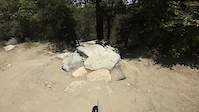
Snow Summit's only double black downhill trail. This trail will be the dh course the 2019 Fox US Open of Mountain Biking. Very steep and raw trail with plenty of chutes, trees, and rocks to throw you off line
Bike Park
Local Trail Association
-

-
Please consider joining or donating to the local trail association to supportdonate to earn trail karma!
trail development & maintenance.
Traditionally Indigenous Territory
More Stats for 10 Ply mountain bike trail trail
-
Altitude change-1,016 ft
-
Altitude min7,115 ft
-
Altitude max8,132 ft
-
Altitude start8,132 ft
-
Altitude end7,115 ft
-
Grade-16.434%
-
Grade max-40.971%
-
Grade min-1%
-
Distance down1 mile
-
Distance flat33 ft
-
Avg time00:08:10
-
Avg reverse time00:32:28
- view trail stats
close
Trail Conditions
- Unknown
- Snow Groomed
- Snow Packed
- Snow Covered
- Snow Cover Inadequate
- Freeze/thaw Cycle
- Icy
- Prevalent Mud
- Wet
- Variable
- Ideal
- Dry
- Very Dry
Trail Flow (Ridden Direction)
Trailforks scans users ridelogs to determine the most popular direction each trail is ridden. A good flowing trail network will have most trails flowing in a single direction according to their intension.
The colour categories are based on what percentage of riders are riding a trail in its intended direction.
The colour categories are based on what percentage of riders are riding a trail in its intended direction.
- > 96%
- > 90%
- > 80%
- > 70%
- > 50%
- < 50%
- bi-directional trail
- no data
Trail Last Ridden
Trailforks scans ridelogs to determine the last time a trail was ridden.
- < 2 days
- < 1 week
- < 2 weeks
- < 1 month
- < 6 months
- > 6 months
Trail Ridden Direction
The intended direction a trail should be ridden.
- Downhill Only
- Downhill Primary
- Both Directions
- Uphill Primary
- Uphill Only
- One Direction
Contribute Details
Colors indicate trail is missing specified detail.
- Description
- Photos
- Description & Photos
- Videos
Trail Popularity ?
Trailforks scans ridelogs to determine which trails are ridden the most in the last 9 months.
Trails are compared with nearby trails in the same city region with a possible 25 colour shades.
Think of this as a heatmap, more rides = more kinetic energy = warmer colors.
- most popular
- popular
- less popular
- not popular
ATV/ORV/OHV Filter
Max Vehicle Width
inches
Radar Time
x
Activity Recordings
Trailforks users anonymized public ridelogs from the past 6 months.
- mountain biking recent
- mountain biking (>6 month)
- hiking (1 year)
- moto (1 year)
Activity Recordings
Trailforks users anonymized public skilogs from the past 12 months.
- Downhill Ski
- Backcountry Ski
- Nordic Ski
Jump Magnitude Heatmap
Heatmap of where riders jump on trails. Zoom in to see individual jumps, click circles to view jump details.
Trails Deemphasized
Trails are shown in grey.
Only show trails with NO bikes.
Save the current map location and zoom level as your default home location whenever this page is loaded.
Save
Directions to 10-ply trailhead
(34.221060, -116.890470)
update trails status or condition
10 Ply Trail Reports
view all reports »
Recent Ridelog Activity on Trail
Past Week
- 30 rides
- 29 miles avg distance
6 Months
- 149 rides
- 27 miles avg distance
All
- 1,064 rides
Photos
no photos have been added for 10 Ply yet, add a photo.
-
+ 0
Cameronrowe998
 (Nov 25, 2021 at 12:34)
Not too bad, one section at the upper half that Everyone struggles with, it’s definitely something to watch out for. But the rust is fun somewhat steep loose “surfing.” Good dh course
[Reply]
 thechrisfr
Steep and loose. That’s the definition of 10-ply. Real downhill trail. 1 section is pretty sketchy with rocks if you don’t know where you are going (walk it first).
Caterpillar is another one that looks too dangerous for me, so I take the right dusty line. Maybe when I’ll have bigger balls I’ll ride caterpillar, but for now I’m already struggling staying on my bike with the loose and steep soil. And I ride Miracle Mile with no issues. This trail is a real double black.
[Reply]
Caterpillar is another one that looks too dangerous for me, so I take the right dusty line. Maybe when I’ll have bigger balls I’ll ride caterpillar, but for now I’m already struggling staying on my bike with the loose and steep soil. And I ride Miracle Mile with no issues. This trail is a real double black.
 dirtchurner
(Aug 18, 2019 at 13:04)
dirtchurner
(Aug 18, 2019 at 13:04)
This line will need more modifications to be a true double black. Currently only a couple sections rate the worthy of single black even with the declination rate. It is more raw than the rest of the current Bike park trails these days. It would do well to have more boulder features put in. Many a advanced rider will not be to challenged by the trail features themselves, just the blown out rocky portions and turns. Was hoping for more true old school raw tech and natural big hit.
[Reply]
Videos
more »


Nearby Trails
- Miracle Mile 72 ft
- Summit Run 335 ft
- Going Green 942 ft
- Pirates Connector 1,821 ft
- Turtle Trail 1,880 ft
Snow Summit Bike Park
- embed 10 Ply trail on your website
- By socalstokie & contributors
- #205840 - 1,804 views
- subscribe
- login to download gpx or kml files.