close
Trail Conditions
- Unknown
- Snow Groomed
- Snow Packed
- Snow Covered
- Snow Cover Inadequate
- Freeze/thaw Cycle
- Icy
- Prevalent Mud
- Wet
- Variable
- Ideal
- Dry
- Very Dry
Trail Flow (Ridden Direction)
Trailforks scans users ridelogs to determine the most popular direction each trail is ridden. A good flowing trail network will have most trails flowing in a single direction according to their intension.
The colour categories are based on what percentage of riders are riding a trail in its intended direction.
The colour categories are based on what percentage of riders are riding a trail in its intended direction.
- > 96%
- > 90%
- > 80%
- > 70%
- > 50%
- < 50%
- bi-directional trail
- no data
Trail Last Ridden
Trailforks scans ridelogs to determine the last time a trail was ridden.
- < 2 days
- < 1 week
- < 2 weeks
- < 1 month
- < 6 months
- > 6 months
Trail Ridden Direction
The intended direction a trail should be ridden.
- Downhill Only
- Downhill Primary
- Both Directions
- Uphill Primary
- Uphill Only
- One Direction
Contribute Details
Colors indicate trail is missing specified detail.
- Description
- Photos
- Description & Photos
- Videos
Trail Popularity ?
Trailforks scans ridelogs to determine which trails are ridden the most in the last 9 months.
Trails are compared with nearby trails in the same city region with a possible 25 colour shades.
Think of this as a heatmap, more rides = more kinetic energy = warmer colors.
- most popular
- popular
- less popular
- not popular
ATV/ORV/OHV Filter
Max Vehicle Width
inches
Radar Time
x
Activity Recordings
Trailforks users anonymized public ridelogs from the past 6 months.
- mountain biking recent
- mountain biking (>6 month)
- hiking (1 year)
- moto (1 year)
Activity Recordings
Trailforks users anonymized public skilogs from the past 12 months.
- Downhill Ski
- Backcountry Ski
- Nordic Ski
Jump Magnitude Heatmap
Heatmap of where riders jump on trails. Zoom in to see individual jumps, click circles to view jump details.
Trails Deemphasized
Trails are shown in grey.
Only show trails with NO bikes.
Save the current map location and zoom level as your default home location whenever this page is loaded.
Save
No description for Ecuador has been added yet!
Login or register to submit one.
Region Details
- 6
- 18
- 63
- 61
- 10
Stats
- Avg Trail Rating
- Trails (view details)
- 158
- Trails Mountain Bike
- 158
- Trails E-Bike
- 49
- Trails Hike
- 126
- Trails Trail Running
- 125
- Trails Horse
- 3
- Total Distance
- 468 miles
- Total Descent
- 272,071 ft
- Total Vertical
- 14,915 ft
- Highest Trailhead
- 14,953 ft
- Reports
- 193
- Photos
- 471
- Ridden Counter
- 1,778
 Articles

Video: Rob Warner and Finn Iles Meet Cowboys and Shamans and Ride Ecuador's Highest Volcano
Nov 27, 2019 from pinkbike.com
Iles and Warner break new ground in South America.
Race Report: Open Shimano Latam 2 - Cuenca, Ecuador
Jul 9, 2019 from pinkbike.com
Riders from all over South America descended on Cuenca, Ecuador for round 2 of the Open Shimano Latam.
Sub Regions
- Azuay (7)
- Cuenca (5)
- Cuenca (5)
- Bolívar (8)
- Guaranda (8)
- Guaranda (8)
- Cañar (4)
- Azogues (4)
- Azogues (4)
- Carchi (0)
- Chimborazo (0)
- Cotopaxi (13)
- Latacunga (10)
- Latacunga (10)
- El Oro (0)
- Esmeraldas (0)
- Galápagos (0)
- Guayas (0)
- Imbabura (0)
- Loja (0)
- Los Ríos (0)
- Manabí (0)
- Morona-Santiago (0)
- Napo (0)
- Orellana (0)
- Pastaza (0)
- Pichincha (84)
- Quito (90)
- Quito (90)
- Pimampiro (21)
- Santa Elena (0)
- Santo Domingo de los Tsáchilas (0)
- Sucumbíos (0)
- Tungurahua (0)
- Baños (0)
- Baños (0)
- Zamora-Chinchipe (0)
- Curia (3)
- Guayaquil (9)
Popular Ecuador Mountain Biking Trails
| status | title | difficulty | rating |
|---|---|---|---|
| Falsa Coral Quito & Valleys | |||
| Metro DH Quito & Valleys | |||
| Filo de Cuchillas Quito & Valleys | |||
| La Roots Quito & Valleys | |||
| Teleferico DH Quito & Valleys | |||
| El Chaquiñan Quito & Valleys | |||
| DH Clasico Quito & Valleys | |||
| Hieleros Guaranda | |||
| Valle de la Muerte El Cerro "Ungui" | |||
| Curvas de Cesped Quito & Valleys | |||
| Venado Blanco Latacunga | |||
| Mama Rumi Guaranda | |||
| Expresso Quito & Valleys | |||
| Paso Alto Quito & Valleys | |||
| El Aliso Santa Rita Andes Marin Bikepark |
Ecuador Mountain Bike Routes
| title | rating | distance |
|---|---|---|
| FCSHUCE 1 Quito & Valleys | 37 miles | |
| E-NFIERNILLO Mitad del Mundo | 37 miles | |
| Enduro Casitahua-Infiernillo 60k Mitad del Mundo | 36 miles | |
| Metropolitano DHll Quito & Valleys | 7 miles | |
| 500s Guayaquil | 15 miles | |
| MDM E-NDURO Mitad del Mundo | 29 miles | |
| ENDURO A LA MITAD DEL MUNDO 50K Mitad del Mundo | 31 miles | |
| CATZUQUI INFIERNILLO ENDURO 45K Mitad del Mundo | 27 miles | |
| ENDURO DEL PERRO Cuenca | 8 miles | |
| el eden baja y sube condorcocha Mitad del Mundo | 8 miles |
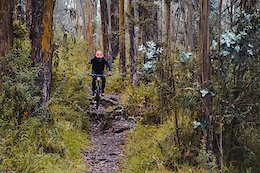
Photos of Ecuador Mountain Bike
trail: Valle de la Muerte
6 |
Jun 28, 2022 @ 7:25pm
Jun 28, 2022
trail: El divino
8 |
Nov 9, 2021 @ 1:54am
Nov 9, 2021
trail: El divino
7 |
Nov 9, 2021 @ 1:54am
Nov 9, 2021
trail: El divino
8 |
Nov 9, 2021 @ 1:54am
Nov 9, 2021
trail: El divino
8 |
Nov 9, 2021 @ 1:54am
Nov 9, 2021
trail: El divino
9 |
Nov 9, 2021 @ 1:54am
Nov 9, 2021
trail: El Muerto
90 |
Nov 14, 2017 @ 7:49am
Nov 14, 2017
trail: El Muerto
329 | | 3 comments
Nov 27, 2012 @ 12:19pm
Nov 27, 2012Videos of Ecuador Mountain Bike
trail: El Chaquiñan
42 |
Dec 11, 2020
trail: Alta Tensión
0:10 |
112 |
Jul 13, 2020

trail: DH Nacional Metropolitano
0:24 |
101 |
Nov 9, 2019
trail: Teleferico DH
0:14 |
150 |
Oct 9, 2019
trail: Hieleros
5:33 |
38 |
Jun 19, 2019
trail: Hieleros
20:24 |
32 |
Jul 15, 2018

trail: 508
7:15 |
60 |
Jul 15, 2018
trail: Nandita
4:27 |
30 |
Apr 15, 2018
Recent Trail Reports
| status | trail | date | condition | info | user |
|---|---|---|---|---|---|
| Hieleros Guaranda | Jul 2, 2022 @ 9:26am Jul 2, 2022 | Ideal | allaroundjoe | ||
| Falsa Coral Quito & Valleys | Jun 30, 2022 @ 7:16am Jun 30, 2022 | Ideal | allaroundjoe | ||
| Valle de la Muerte El Cerro "Ungui" | Jun 29, 2022 @ 8:03am Jun 29, 2022 | Variable | allaroundjoe | ||
| El Infiernillo Completo Mitad del Mundo | Jun 26, 2022 @ 6:41am Jun 26, 2022 | Variable | allaroundjoe | ||
| Periup Quito & Valleys | Jan 31, 2022 @ 7:25am Jan 31, 2022 | Wet | periclespico | ||
| Venado Blanco Latacunga | Jan 31, 2022 @ 6:22am Jan 31, 2022 | Ideal | slagathar | ||
| Gnomos Latacunga | Jan 31, 2022 @ 6:22am Jan 31, 2022 | Ideal | slagathar | ||
| Conejo Sabio Latacunga | Jan 31, 2022 @ 6:22am Jan 31, 2022 | Ideal | slagathar | ||
| La Marca Mitad del Mundo | Jan 30, 2022 @ 6:00am Jan 30, 2022 | Ideal | Brinkmann | ||
| La Jibara Quito & Valleys | Jan 11, 2022 @ 7:37am Jan 11, 2022 | Variable | periclespico |
Recent Comments
| username | type | title | comment | date | |
|---|---|---|---|---|---|
 | trail | BIENOS DIAS, EN EL MAPA ACTUAL DEL BIKE PARK,... | May 19, 2021 @ 6:41am May 19, 2021 | ||
| trail | Atención que el último salto está tapado de... | Mar 25, 2021 @ 11:42am Mar 25, 2021 | ||
| trail | Epic Trail! One of the best we did on the... | Jan 10, 2020 @ 3:55pm Jan 10, 2020 | ||
| report | This trail is no longer rideable. Local... | Apr 12, 2019 @ 4:43am Apr 12, 2019 | ||
| trail | GRACIAS | Feb 23, 2018 @ 10:11am Feb 23, 2018 |
Bike & Skill Parks
| name | type | city | rating |
|---|---|---|---|
| Bike Land | skill park | Quito | |
| Campo Bici | skill park | Quito | |
| Carcelen BMX Park | skill park | Quito | |
| Carolina BMX Park | skill park | Quito | |
| Carolina BMX Race Track | skill park | Quito |
Pinkbike Articles
Jul 9, 2019
 Race Report: Open Shimano Latam 2 - Cuenca, Ecuador
Riders from all over South America descended on Cuenca, Ecuador for round 2 of the Open Shimano Latam.
Oct 4, 2020
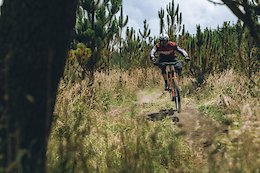 Photo Story: Shredding Trails In Sight of the World's Highest Active Volcano
Exploring the trails of Cotopaxi bike park in Ecuador which sits adjacent to the Cotopaxi volcano.
Jun 9, 2020
 Exploring the Metropolitan Park Trails in Ecuador
Checking out some of the trails at one of the growing mtb hotspots in Ecuador.
Activity Type Stats
| activitytype | trails | distance | descent | descent distance | total vertical | rating | global rank | state rank | photos | reports | routes | ridelogs |
|---|---|---|---|---|---|---|---|---|---|---|---|---|
| Mountain Bike | 158 | 468 miles | 272,070 ft | 331 miles | 14,915 ft | #43 | 471 | 192 | 17 | 22,321 | ||
| E-Bike | 49 | 111 miles | 41,424 ft | 56 miles | 14,022 ft | #52 | 165 | 12 | 554 | |||
| Hike | 126 | 417 miles | 237,175 ft | 290 miles | 14,915 ft | #41 | 185 | 2 | 617 | |||
| Trail Running | 125 | 406 miles | 231,742 ft | 282 miles | 14,915 ft | #40 | 185 | 1 | 70 | |||
| Horse | 3 | 10 miles | 2,251 ft | 5 miles | 10,279 ft | #15 | 127 | 1 |
- By despinosaf & contributors
- Admins: apply
- #3269 - 10,838 views
- ecuador activity log | embed map of Ecuador mountain bike trails | ecuador mountain biking points of interest
-
- subscribe
- 3d map
Downloading of trail gps tracks in kml & gpx formats is enabled for Ecuador.
You must login to download files.