close
Trail Conditions
- Unknown
- Snow Groomed
- Snow Packed
- Snow Covered
- Snow Cover Inadequate
- Freeze/thaw Cycle
- Icy
- Prevalent Mud
- Wet
- Variable
- Ideal
- Dry
- Very Dry
Trail Flow (Ridden Direction)
Trailforks scans users ridelogs to determine the most popular direction each trail is ridden. A good flowing trail network will have most trails flowing in a single direction according to their intension.
The colour categories are based on what percentage of riders are riding a trail in its intended direction.
The colour categories are based on what percentage of riders are riding a trail in its intended direction.
- > 96%
- > 90%
- > 80%
- > 70%
- > 50%
- < 50%
- bi-directional trail
- no data
Trail Last Ridden
Trailforks scans ridelogs to determine the last time a trail was ridden.
- < 2 days
- < 1 week
- < 2 weeks
- < 1 month
- < 6 months
- > 6 months
Trail Ridden Direction
The intended direction a trail should be ridden.
- Downhill Only
- Downhill Primary
- Both Directions
- Uphill Primary
- Uphill Only
- One Direction
Contribute Details
Colors indicate trail is missing specified detail.
- Description
- Photos
- Description & Photos
- Videos
Trail Popularity ?
Trailforks scans ridelogs to determine which trails are ridden the most in the last 9 months.
Trails are compared with nearby trails in the same city region with a possible 25 colour shades.
Think of this as a heatmap, more rides = more kinetic energy = warmer colors.
- most popular
- popular
- less popular
- not popular
ATV/ORV/OHV Filter
Max Vehicle Width
inches
Radar Time
x
Activity Recordings
Trailforks users anonymized public ridelogs from the past 6 months.
- mountain biking recent
- mountain biking (>6 month)
- hiking (1 year)
- moto (1 year)
Activity Recordings
Trailforks users anonymized public skilogs from the past 12 months.
- Downhill Ski
- Backcountry Ski
- Nordic Ski
Jump Magnitude Heatmap
Heatmap of where riders jump on trails. Zoom in to see individual jumps, click circles to view jump details.
Trails Deemphasized
Trails are shown in grey.
Only show trails with NO bikes.
Save the current map location and zoom level as your default home location whenever this page is loaded.
SavePopular Trail Networks
view all areas »
No description for Ireland has been added yet!
Login or register to submit one.
AKA: Republic Of Ireland
This region uses the Uk/Euro style trail grading system.
Stats
- Avg Trail Rating
- Trails (view details)
- 982
- Trails Mountain Bike
- 810
- Trails E-Bike
- 299
- Trails Hike
- 715
- Trails Trail Running
- 719
- Trails Horse
- 13
- Trails Dirtbike/Moto
- 2
- Total Distance
- 572 miles
- Total Descent
- 152,762 ft
- Total Vertical
- 2,927 ft
- Highest Trailhead
- 2,939 ft
- Reports
- 5,667
- Photos
- 717
- Ridden Counter
- 53,919
 Articles
Race report: Gravity Enduro Series 2019 - Round 3 Slade Valley
Jun 17, 2019 from pinkbike.com
Mint conditions for the 3rd race of the Gravity Enduro Series in Slade valley, with near 250 riders registered and enjoying a great day in the saddle.
Race Preview: Gravity Enduro Series 2019 - Round 3 Slade Valley
Jun 16, 2019 from pinkbike.com
The third stop of the Vitus Gravity Enduro Series 2019 will take place in Slade Valley, just 30min East from Dublin. 250 riders will get into the...
Sub Regions
- Border Region (17)
- Dublin Region (230)
- Dún Laoghaire–Rathdown (174)
- Fingal (3)
- South Dublin (52)
- Dublin (199)
- Dún Laoghaire–Rathdown (174)
- Mid-East Region (279)
- County Louth (41)
- County Wicklow (236)
- Arklow (19)
- Bray (24)
- Co. Wicklow (20)
- Glendalough (14)
- Glenealy (48)
- Kildare (2)
- Drogheda (0)
- Wicklow (100)
- County Louth (41)
- Mid-West Region (37)
- Clare (9)
- Killaloe (7)
- Clare (2)
- Lisdoonvarna (2)
- County Limerick (14)
- Limerick (9)
- County Tipperary (14)
- Clare (9)
- Midlands Region (67)
- Offaly (43)
- Tullamore (25)
- Westmeath (20)
- Ballymanus (17)
- Offaly (43)
- South-East Region (106)
- South-West Region (57)
- West Region (9)
- County Galway (9)
- Clarinbridge (1)
- Galway (7)
- County Galway (9)
Popular Ireland Mountain Biking Trails
| status | title | difficulty | rating |
|---|---|---|---|
| Skyline Ticknock | |||
| Metro 1 Upper Rock Garden Ticknock | |||
| Euroskeptic Ticknock | |||
| Blazin' Saddles (Euro) Ticknock | |||
| Dual Slalom The GAP | |||
| Tickety Boo The GAP | |||
| Euroskeptic Lower Ticknock | |||
| Connector Skyline to Boneshaker Ticknock | |||
| Doubletrack Ticknock | |||
| Byrner The GAP | |||
| Expressway Ballinastoe | |||
| After Burner lower (after rebuild) Ticknock | |||
| Bump n' Grind Ballinastoe | |||
| Easy Rider The GAP | |||
| Witches Cauldron The GAP |
Ireland Mountain Bike Routes
| title | rating | distance |
|---|---|---|
| Short weekday route Ticknock | 5 miles | |
| Wicklow Way full: Marlay Park to Clonegal County Wicklow | 79 miles | |
| Coolaney trail center upper reds+black Cooloney Mountain Bike Trail | 11 miles | |
| Garrane (White) Loop Ballyhoura | 21 miles | |
| Ballinastoe loop Ballinastoe | 8 miles | |
| Coolaney trail center lower loops + blue + black Cooloney Mountain Bike Trail | 10 miles | |
| Ballyhoura mountain - red loop Ballyhoura | 29 miles | |
| Ballyhoura mountain - blue loop Ballyhoura | 26 miles | |
| Ballyhoura mountain - brown loop Ballyhoura | 11 miles | |
| All Coolaney trails Cooloney Mountain Bike Trail | 20 miles |
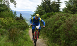
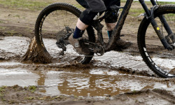
Photos of Ireland Mountain Bike
trail: Therapy
16 |
Apr 19, 2022 @ 7:14am
Apr 19, 2022
trail: Clarinbridge
13 |
Mar 20, 2022 @ 2:45am
Mar 20, 2022
trail: Clarinbridge
14 |
Mar 20, 2022 @ 2:45am
Mar 20, 2022
trail: Clarinbridge
14 |
Mar 20, 2022 @ 2:45am
Mar 20, 2022
trail: Clarinbridge
18 |
Mar 20, 2022 @ 2:45am
Mar 20, 2022
trail: Mountrussell Loop
34 |
Feb 27, 2022 @ 2:58pm
Feb 27, 2022
trail: Derroura Climb
54 |
Oct 14, 2020 @ 5:20pm
Oct 14, 2020
trail: Derroura Climb
107 |
Aug 17, 2018 @ 9:23pm
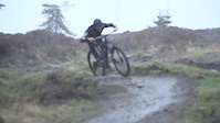
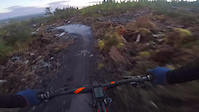
Aug 17, 2018Videos of Ireland Mountain Bike

trail: Leap of the Bunny
113 |
Apr 23, 2021
trail: Metro 1 Upper Rock Garden
153 |
Mar 27, 2021

trail: Ball Breaker
41 |
Feb 19, 2021

trail: After Burner (upper)
76 |
Jan 22, 2021

29 |
Jan 22, 2021
trail: No Delay
272 |
Jan 4, 2021

trail: After Burner (upper)
111 |
Dec 4, 2020
trail: 13 Jumps
0:05 |
195 |
Jul 16, 2020
Current Trail Warnings
| status | trail | date | condition | user | info |
|---|---|---|---|---|---|
| Covid Ass Craic Cruagh Woods | Jun 18, 2022 @ 2:52am Jun 18, 2022 | Dry | hughperman | forestry fucked the whole bottom section |
Recent Trail Reports
| status | trail | date | condition | info | user |
|---|---|---|---|---|---|
| Selection Box Kilbrannish | Jul 3, 2022 @ 4:52am 3 days | Prevalent Mud | Kkhornet | ||
| Euroskeptic Lower Ticknock | Jul 2, 2022 @ 1:43am Jul 2, 2022 | Ideal | frankgalan | ||
| Nowhere Easy Exit Ticknock | Jul 2, 2022 @ 1:43am Jul 2, 2022 | Wet | frankgalan | ||
| Bungle Jungle Ticknock | Jul 2, 2022 @ 1:43am Jul 2, 2022 | Ideal | frankgalan | ||
| Full Traverse (high) Ticknock | Jul 2, 2022 @ 1:43am Jul 2, 2022 | Prevalent Mud | frankgalan | ||
| Fireroad Ticknock | Jul 2, 2022 @ 1:43am Jul 2, 2022 | Wet | frankgalan | ||
| T-connector left to deadmans pool Ticknock | Jul 2, 2022 @ 1:43am Jul 2, 2022 | Dry | frankgalan | ||
| Dogtown to Dreamtrack Ticknock | Jul 2, 2022 @ 1:43am Jul 2, 2022 | Dry | frankgalan | ||
| Connector Skyline to Boneshaker Ticknock | Jul 2, 2022 @ 1:43am Jul 2, 2022 | Dry | frankgalan | ||
| Doubletrack Ticknock | Jul 2, 2022 @ 1:43am Jul 2, 2022 | Dry | frankgalan |
Recent Comments
| username | type | title | comment | date | |
|---|---|---|---|---|---|
 | trail | Comes off the side of Cookie Monster. Bit of a... | Jun 17, 2022 @ 9:12am Jun 17, 2022 | ||
| trail | Great some steep stuff and a good bit of tech... | Apr 24, 2022 @ 7:47am Apr 24, 2022 | ||
| trail | Ah shit this was one of my favourite tracks... | Mar 29, 2022 @ 1:20am Mar 29, 2022 | ||
| trail | Unfortunately this trail is now gone, along... | Jan 25, 2022 @ 7:03am Jan 25, 2022 | ||
| trail | Nice and flowy | Jan 24, 2022 @ 8:22am Jan 24, 2022 |
Bike & Skill Parks
| name | type | city | rating |
|---|---|---|---|
| Bike Park Ireland | bike park | ||
| The GAP | bike park | Dublin | |
| Belmont Pumptrack | skill park | Bray | |
| Bike Park Ireland Pumptrack | skill park | ||
| Cork BMX track | skill park | Cork |
Upcoming Local Events
Activity Type Stats
| activitytype | trails | distance | descent | descent distance | total vertical | rating | global rank | state rank | photos | reports | routes | ridelogs |
|---|---|---|---|---|---|---|---|---|---|---|---|---|
| Mountain Bike | 810 | 456 miles | 131,214 ft | 247 miles | 2,051 ft | #23 | 716 | 5,665 | 74 | 71,899 | ||
| E-Bike | 299 | 176 miles | 44,537 ft | 88 miles | 1,847 ft | #23 | 1 | 4,974 | 44 | 2,605 | ||
| Hike | 715 | 459 miles | 106,427 ft | 223 miles | 2,927 ft | #24 | 5,514 | 12 | 2,110 | |||
| Trail Running | 719 | 460 miles | 107,113 ft | 225 miles | 2,927 ft | #24 | 5,516 | 14 | 597 | |||
| Horse | 13 | 10 miles | 1,102 ft | 3 miles | 1,073 ft | #34 | 555 | |||||
| Dirtbike/Moto | 2 | 3 miles | 180 ft | 2,887 ft | 676 ft | 552 | 3 |
- By canadaka
 Trailforks & contributors
 - Admins: elyari
- #3141 - 37,758 views
- ireland activity log | embed map of Ireland mountain bike trails | ireland mountain biking points of interest
-
- subscribe
- 3d map
Downloading of trail gps tracks in kml & gpx formats is enabled for Ireland.
You must login to download files.