close
Trail Conditions
- Unknown
- Snow Groomed
- Snow Packed
- Snow Covered
- Snow Cover Inadequate
- Freeze/thaw Cycle
- Icy
- Prevalent Mud
- Wet
- Variable
- Ideal
- Dry
- Very Dry
Trail Flow (Ridden Direction)
Trailforks scans users ridelogs to determine the most popular direction each trail is ridden. A good flowing trail network will have most trails flowing in a single direction according to their intension.
The colour categories are based on what percentage of riders are riding a trail in its intended direction.
The colour categories are based on what percentage of riders are riding a trail in its intended direction.
- > 96%
- > 90%
- > 80%
- > 70%
- > 50%
- < 50%
- bi-directional trail
- no data
Trail Last Ridden
Trailforks scans ridelogs to determine the last time a trail was ridden.
- < 2 days
- < 1 week
- < 2 weeks
- < 1 month
- < 6 months
- > 6 months
Trail Ridden Direction
The intended direction a trail should be ridden.
- Downhill Only
- Downhill Primary
- Both Directions
- Uphill Primary
- Uphill Only
- One Direction
Contribute Details
Colors indicate trail is missing specified detail.
- Description
- Photos
- Description & Photos
- Videos
Trail Popularity ?
Trailforks scans ridelogs to determine which trails are ridden the most in the last 9 months.
Trails are compared with nearby trails in the same city region with a possible 25 colour shades.
Think of this as a heatmap, more rides = more kinetic energy = warmer colors.
- most popular
- popular
- less popular
- not popular
ATV/ORV/OHV Filter
Max Vehicle Width
inches
Radar Time
x
Activity Recordings
Trailforks users anonymized public ridelogs from the past 6 months.
- mountain biking recent
- mountain biking (>6 month)
- hiking (1 year)
- moto (1 year)
Activity Recordings
Trailforks users anonymized public skilogs from the past 12 months.
- Downhill Ski
- Backcountry Ski
- Nordic Ski
Jump Magnitude Heatmap
Heatmap of where riders jump on trails. Zoom in to see individual jumps, click circles to view jump details.
Trails Deemphasized
Trails are shown in grey.
Only show trails with NO bikes.
Save the current map location and zoom level as your default home location whenever this page is loaded.
SavePopular Trail Networks
view all areas »
No description for Kenya has been added yet!
Login or register to submit one.
Region Details
- 162
- 6
- 99
- 84
- 37
- 1
Stats
- Avg Trail Rating
- Trails (view details)
- 389
- Trails Mountain Bike
- 389
- Trails E-Bike
- 374
- Trails Hike
- 383
- Trails Trail Running
- 382
- Trails Horse
- 3
- Trails Dirtbike/Moto
- 2
- Total Distance
- 645 miles
- Total Descent
- 113,715 ft
- Total Vertical
- 10,946 ft
- Highest Trailhead
- 10,970 ft
- Reports
- 51
- Photos
- 182
- Ridden Counter
- 1,095
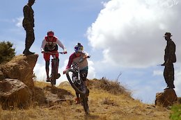
 Articles
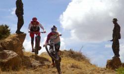
Video: Rob Warner & Matt Jones Tackle Mount Kenya
Nov 13, 2019 from pinkbike.com
Dodging wildlife and meeting the locals in east Africa
Sub Regions
- Baringo County (3)
- Kabarnet (3)
- Elgeyo Marakwet County (23)
- Iten (23)
- Cherengani Hills (6)
- Iten Trails (17)
- Iten (23)
- Kajiado County (0)
- Kiambu County (76)
- Kijabe (72)
- Kijabe Trails (69)
- Kimende (4)
- Kijabe (72)
- Kilifi County (148)
- Kilifi (147)
- Mwangea (8)
- Vipingo Trails (139)
- Watamu (1)
- Sokoke Trails (1)
- Kilifi (147)
- Laikipia County (2)
- Nanyuki (2)
- Borana Trails (2)
- Nanyuki (2)
- Machakos County (0)
- Makueni County (3)
- Wote (3)
- Ulu Conservancy (3)
- Wote (3)
- Migori County (0)
- Murang'a County (5)
- Sagana (5)
- Sagana Trails (5)
- Sagana (5)
- Nairobi County (83)
- Nairobi (83)
- Karura Forest (74)
- Ngong Hills (7)
- Ngong Road Forest (1)
- Two Rivers Sports District (1)
- Nairobi (83)
- Nakuru County (1)
- Nakuru (1)
- Londiani Trails (1)
- Nakuru (1)
- Narok County (0)
- Nyandarua County (0)
- Nyeri County (1)
- Karatina (1)
- Karatina Trails (1)
- Karatina (1)
- Taita Taveta County (45)
- Wundanyi (45)
- Taita Hills (45)
- Wundanyi (45)
Popular Kenya Mountain Biking Trails
| status | title | difficulty | rating |
|---|---|---|---|
| Family Trail Karura Forest | |||
| Reber's Revenge Kijabe Trails | |||
| South Dam Vipingo Trails | |||
| Bokini South Vipingo Trails | |||
| Name 3? Karura Forest | |||
| Kima Trail Karura Forest | |||
| Vipingo Jump Line Vipingo Trails | |||
| Access Road Karura Forest | |||
| Access Road Karura Forest | |||
| Access Road Karura Forest | |||
| Speed Alley Kijabe Trails | |||
| Mahuga Trail (Long John's Descent) Karura Forest | |||
| Milk & Honey Iten Trails | |||
| Access Road Karura Forest | |||
| Access Road Karura Forest |
Kenya Mountain Bike Routes
| title | rating | distance |
|---|---|---|
| Hit the Lights - quick route Kijabe Trails | 4 miles | |
| Dindiri Bokini Loop Vipingo Trails | 10 miles | |
| Pingilikani Loop Vipingo Trails | 6 miles | |
| Vipingo Jimani Loop Vipingo Trails | 16 miles | |
| Barnes Trail and Rockpile Kijabe Trails | 9 miles | |
| Kijabe Downhill Fun Kijabe Trails | 2 miles | |
| Barnes, Coke Drop, Awesome Sauce Kijabe | 18 miles | |
| Lusigeti Loop Kenya | 34 miles | |
| Getting to Singore Forest Elgeyo Marakwet County | 5 miles | |
| Taita Enduro 2022 race Taita Hills | 20 miles |
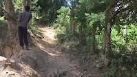
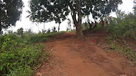
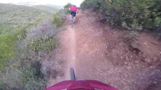
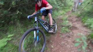
Photos of Kenya Mountain Bike
trail: Mission
7 |
Jun 14, 2022 @ 11:50am
Jun 14, 2022
trail: WaterWorld
5 |
Jun 12, 2022 @ 8:26pm
Jun 12, 2022
trail: Kidongo Col
1 |
May 2, 2022 @ 5:14am
May 2, 2022
trail: Three Dogs Hill
5 |
May 2, 2022 @ 5:13am
May 2, 2022
trail: Future President
4 |
May 2, 2022 @ 5:12am
May 2, 2022
trail: Yappy Dog Trail
5 |
Apr 27, 2022 @ 10:07am
Apr 27, 2022
trail: Round House Link
5 |
Apr 10, 2022 @ 11:20am
Apr 10, 2022
trail: Foresty
25 |
Dec 13, 2021 @ 10:49am
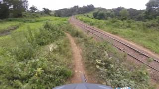
Dec 13, 2021Videos of Kenya Mountain Bike
trail: Wundanyi Ridge
29 |
May 24, 2021
trail: Down Dog
0:06 |
63 |
Aug 12, 2020

trail: Under The "S" / Adamsbridge
3:24 |
49 |
Dec 13, 2021 , Kijabe
trail: Brickyard
4:41 |
67 |
Dec 13, 2021 , Kijabe
trail: Dead Drop
4:56 |
55 |
Dec 13, 2021 , Kijabe

trail: Awesome Sauce
9:32 |
54 |
Dec 13, 2021 , Kijabe
trail: Rockpile
3:52 |
54 |
Dec 13, 2021 , Kijabe
Recent Trail Reports
| status | trail | date | condition | info | user |
|---|---|---|---|---|---|
| Maingi Lower Road Kijabe Trails | Jan 24, 2022 @ 7:19am Jan 24, 2022 | Ideal | evanaso | ||
| Ferris Bueller's Day Off Kijabe Trails | Jan 24, 2022 @ 7:19am Jan 24, 2022 | Ideal | evanaso | ||
| Smiley Kijabe Trails | Jan 24, 2022 @ 7:19am Jan 24, 2022 | Dry | evanaso | ||
| Wall of Pain Connector Kijabe Trails | Jan 24, 2022 @ 7:19am Jan 24, 2022 | Dry | evanaso | ||
| Wall of Pain Kijabe Trails | Jan 24, 2022 @ 7:19am Jan 24, 2022 | Dry | evanaso | ||
| Wall of Pain Part 2 Kijabe Trails | Jan 24, 2022 @ 7:19am Jan 24, 2022 | Ideal | evanaso | ||
| Under the S Bailout Kijabe Trails | Jan 24, 2022 @ 7:19am Jan 24, 2022 | Ideal | evanaso | ||
| Pylon Pass Kijabe Trails | Jan 23, 2022 @ 7:43am Jan 23, 2022 | Dry | Ianson | ||
| Giants & Bees Kijabe Trails | Jan 23, 2022 @ 7:40am Jan 23, 2022 | Dry | Ianson | ||
| Dead Drop Kijabe Trails | Dec 25, 2021 @ 6:21am Dec 25, 2021 | Dry | adavis20 Kijabe |
Recent Comments
| username | type | title | comment | date | |
|---|---|---|---|---|---|
 | trail | Watch out for the big drop at the end! | Feb 28, 2022 @ 10:19am Feb 28, 2022 | ||
 | trail | Favorite trail in kijabe | Jan 23, 2022 @ 7:25am Jan 23, 2022 | ||
 | trail | Great way to get up the hill | Sep 7, 2020 @ 12:14pm Sep 7, 2020 | ||
| trail | Comfort agree with the description. Worth the... | Sep 7, 2020 @ 12:06pm Sep 7, 2020 | ||
| trail | Fun track to get ready for take off! | Jun 5, 2019 @ 10:22am Jun 5, 2019 |
Bike & Skill Parks
| name | type | city | rating |
|---|---|---|---|
| Twiga Place | skill park | Nairobi |
Pinkbike Articles
Nov 13, 2019
 Video: Rob Warner & Matt Jones Tackle Mount Kenya
Dodging wildlife and meeting the locals in east Africa
Mar 20, 2021
 Video and Race Report: East Africa Enduro Series 2021 - Round 1
Catch up with all the racing action from the first round of the 2021 East Africa Enduro Series.
Feb 18, 2019
 Race Report: Joe Nation and Rae Morrison Win the Final Round of the Asia Pacific Enduro Series
All the action from the Phoenix Enduro in Christchurch's Adventure Park.
Activity Type Stats
| activitytype | trails | distance | descent | descent distance | total vertical | rating | global rank | state rank | photos | reports | routes | ridelogs |
|---|---|---|---|---|---|---|---|---|---|---|---|---|
| Mountain Bike | 389 | 645 miles | 113,714 ft | 311 miles | 10,945 ft | #68 | 182 | 51 | 29 | 5,108 | ||
| E-Bike | 374 | 633 miles | 110,571 ft | 305 miles | 10,945 ft | #51 | 43 | 18 | 61 | |||
| Hike | 383 | 638 miles | 112,864 ft | 309 miles | 10,945 ft | #62 | 49 | 9 | 481 | |||
| Trail Running | 382 | 608 miles | 109,482 ft | 298 miles | 10,945 ft | #62 | 49 | 10 | 31 | |||
| Horse | 3 | 4 miles | 1,165 ft | 3 miles | 2,598 ft | 22 | ||||||
| Dirtbike/Moto | 2 | 1 mile | 26 ft | 1,916 ft | 7,805 ft | 22 |
- By canadaka
 Trailforks & contributors
 - Admins: Kenya
- #15001 - 8,466 views
- kenya activity log | embed map of Kenya mountain bike trails | kenya mountain biking points of interest
-
- subscribe
- 3d map
Downloading of trail gps tracks in kml & gpx formats is enabled for Kenya.
You must login to download files.