close
Trail Conditions
- Unknown
- Snow Groomed
- Snow Packed
- Snow Covered
- Snow Cover Inadequate
- Freeze/thaw Cycle
- Icy
- Prevalent Mud
- Wet
- Variable
- Ideal
- Dry
- Very Dry
Trail Flow (Ridden Direction)
Trailforks scans users ridelogs to determine the most popular direction each trail is ridden. A good flowing trail network will have most trails flowing in a single direction according to their intension.
The colour categories are based on what percentage of riders are riding a trail in its intended direction.
The colour categories are based on what percentage of riders are riding a trail in its intended direction.
- > 96%
- > 90%
- > 80%
- > 70%
- > 50%
- < 50%
- bi-directional trail
- no data
Trail Last Ridden
Trailforks scans ridelogs to determine the last time a trail was ridden.
- < 2 days
- < 1 week
- < 2 weeks
- < 1 month
- < 6 months
- > 6 months
Trail Ridden Direction
The intended direction a trail should be ridden.
- Downhill Only
- Downhill Primary
- Both Directions
- Uphill Primary
- Uphill Only
- One Direction
Contribute Details
Colors indicate trail is missing specified detail.
- Description
- Photos
- Description & Photos
- Videos
Trail Popularity ?
Trailforks scans ridelogs to determine which trails are ridden the most in the last 9 months.
Trails are compared with nearby trails in the same city region with a possible 25 colour shades.
Think of this as a heatmap, more rides = more kinetic energy = warmer colors.
- most popular
- popular
- less popular
- not popular
ATV/ORV/OHV Filter
Max Vehicle Width
inches
Radar Time
x
Activity Recordings
Trailforks users anonymized public ridelogs from the past 6 months.
- mountain biking recent
- mountain biking (>6 month)
- hiking (1 year)
- moto (1 year)
Activity Recordings
Trailforks users anonymized public skilogs from the past 12 months.
- Downhill Ski
- Backcountry Ski
- Nordic Ski
Jump Magnitude Heatmap
Heatmap of where riders jump on trails. Zoom in to see individual jumps, click circles to view jump details.
Trails Deemphasized
Trails are shown in grey.
Only show trails with NO bikes.
Save the current map location and zoom level as your default home location whenever this page is loaded.
SaveKyrgyzstan:
Snow-capped mountain passes, glistening lake-side horse trails and high altitude trekking that takes your breath away. The adventurous traveler won’t fail to be seduced by the rugged charm of the Switzerland of Central Asia.
Unknown Epic.
Snow-capped mountain passes, glistening lake-side horse trails and high altitude trekking that takes your breath away. The adventurous traveler won’t fail to be seduced by the rugged charm of the Switzerland of Central Asia.
Unknown Epic.
Region Details
- 18
- 2
- 19
- 35
- 23
- 3
Stats
- Avg Trail Rating
- Trails (view details)
- 120
- Trails Mountain Bike
- 100
- Trails E-Bike
- 44
- Trails Hike
- 107
- Trails Trail Running
- 108
- Trails Horse
- 13
- Trails Dirtbike/Moto
- 13
- Trails Observed Trials
- 13
- Trails ATV/ORV/OHV
- 13
- Trails Backcountry Ski
- 5
- Total Distance
- 791 miles
- Total Descent
- 182,809 ft
- Total Vertical
- 12,568 ft
- Highest Trailhead
- 14,902 ft
- Reports
- 1
- Photos
- 50
- Ridden Counter
- 44
Sub Regions
- Chuy Region (Чүй областы) (6)
- Issyk Kul Region (Ысык-Көл областы) (28)
- Bokombaevo (6)
- Jyrgalan (2)
- Karakol (17)
- Bokombaevo (6)
- Jalal-Abad Region (Жалалабат областы) (0)
- Naryn Region (0)
- Osh Region (Kyrgyz: Ош областы) (0)
- Talas Region (Талас областы) (0)
- Bishkek (28)
- Kyzart (2)
- Naryn (1)
- Sokuluk (12)
- Alamedin (7)
- Issyk Ata (14)
- Karagachevaya Park (0)
Popular Kyrgyzstan Mountain Biking Trails
| status | title | difficulty | rating |
|---|---|---|---|
| Pass Kyrgyzstan | |||
| Birch Groove Kashka Suu | |||
| Biek Too Loop Bishkek | |||
| Access Road Bishkek | |||
| Turtle Mt Bishkek | |||
| Alamedin River Trail (West) Alamedin | |||
| Kaiyrma Aryk - Alpine Trail Ak-suu Mountains - Southern Karakol | |||
| Tulpar Tash Jyrgalan | |||
| Kok Bel Waterfall Loop Issyk Kul Region (Ысык-Көл областы) | |||
| Birch Grove Loop Jyrgalan | |||
| Kashka Suu Gorge Karakol | |||
| Karakol Ski Base Tour Karakol | |||
| Kolduu Suu Mountain Lake Kyzart | |||
| Tokbay-Ismail Loop Sokuluk | |||
| Kok Jar Loop Bishkek |
Kyrgyzstan Mountain Bike Routes
| title | rating | distance |
|---|---|---|
| Salt Lake Bokombaevo | 13 miles | |
| Boz Salkyn -Tosor Gorge Bokombaevo | 29 miles | |
| Lama Channel Kyzart | 12 miles | |
| Naryn City Panorama Ride Naryn | 20 miles | |
| Przhevalsky Museum Tour Karakol | 19 miles | |
| Salkyn Tor Naryn | 19 miles | |
| Temirlan Stone Jyrgalan | 18 miles |
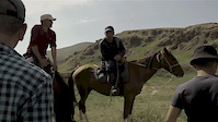
Photos of Kyrgyzstan Mountain Bike
trail: Boz Salkyn - Tosor -Skazka
90 |
Mar 22, 2018 @ 11:02pm
Mar 22, 2018
trail: Boz Salkyn - Tosor -Skazka
92 |
Mar 22, 2018 @ 11:00pm
Mar 22, 2018
trail: Boz Salkyn - Tosor -Skazka
76 | | 2 comments
Mar 22, 2018 @ 11:00pm
Mar 22, 2018
trail: Boz Salkyn - Tosor -Skazka
89 | | 2 comments
Mar 22, 2018 @ 10:58pm
Mar 22, 2018
trail: Boz Salkyn - Tosor -Skazka
46 |
Mar 22, 2018 @ 10:57pm
Mar 22, 2018
trail: Boz Salkyn - Tosor -Skazka
43 |
Mar 22, 2018 @ 10:56pm
Mar 22, 2018
trail: Boz Salkyn - Tosor -Skazka
41 |
Mar 22, 2018 @ 10:56pm
Mar 22, 2018
trail: Boz Salkyn - Tosor -Skazka
46 |
Mar 22, 2018 @ 10:56pm
Mar 22, 2018Videos of Kyrgyzstan Mountain Bike
trail: Kolduu Suu Mountain Lake
1:00 |
27 |
Dec 27, 2017
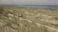
trail: Salt Lake
1:00 |
20 |
Dec 26, 2017
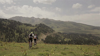
trail: Birch Grove Loop
1:00 |
36 |
Dec 11, 2017

349 |
Dec 11, 2017
Recent Trail Reports
| status | trail | date | condition | info | user |
|---|---|---|---|---|---|
| пони саат (Pony Time) Bishkek | Jan 4, 2017 @ 8:26am Jan 4, 2017 | Snow Covered | boxxerace TRAILFORKS |
Recent Comments
| username | type | title | comment | date | |
|---|---|---|---|---|---|
 | trail | When it's riddeable (snow condition optimal)? | May 24, 2020 @ 9:57pm May 24, 2020 | ||
 | trail | WOW that's long! Now that's a trail! :p | Dec 16, 2019 @ 3:24am Dec 16, 2019 | ||
| trail | The climb is solid, but the backside needs... | Apr 17, 2018 @ 10:05am Apr 17, 2018 | ||
| trail | I tried the uphill, not possible to ride up,... | Sep 11, 2017 @ 5:56pm Sep 11, 2017 | ||
| trail | This trail was not rideable in September 2017... | Sep 11, 2017 @ 5:55pm Sep 11, 2017 |
Activity Type Stats
| activitytype | trails | distance | descent | descent distance | total vertical | rating | global rank | state rank | photos | reports | routes | ridelogs |
|---|---|---|---|---|---|---|---|---|---|---|---|---|
| Mountain Bike | 100 | 669 miles | 155,072 ft | 334 miles | 12,569 ft | #75 | 50 | 1 | 7 | 514 | ||
| E-Bike | 44 | 332 miles | 70,617 ft | 184 miles | 11,319 ft | #54 | 1 | |||||
| Hike | 107 | 721 miles | 173,117 ft | 347 miles | 12,569 ft | #69 | 1 | 1 | 88 | |||
| Trail Running | 108 | 734 miles | 174,787 ft | 353 miles | 12,569 ft | #69 | 1 | 1 | ||||
| Horse | 13 | 23 miles | 7,802 ft | 9 miles | 7,831 ft | 1 | ||||||
| Dirtbike/Moto | 13 | 23 miles | 7,802 ft | 9 miles | 7,831 ft | 1 | ||||||
| Observed Trials | 13 | 23 miles | 7,802 ft | 9 miles | 7,831 ft | |||||||
| ATV/ORV/OHV | 13 | 23 miles | 7,802 ft | 9 miles | 7,831 ft | 1 | ||||||
| Backcountry Ski | 5 | 5 miles | 16 ft | 528 ft | 2,963 ft | 9 |
- By dis2fuji & contributors
- Admins: boxxerace
- #5612 - 7,159 views
- kyrgyzstan activity log | embed map of Kyrgyzstan mountain bike trails | kyrgyzstan mountain biking points of interest
-
- subscribe
- 3d map
Downloading of trail gps tracks in kml & gpx formats is enabled for Kyrgyzstan.
You must login to download files.