close
Trail Conditions
- Unknown
- Snow Groomed
- Snow Packed
- Snow Covered
- Snow Cover Inadequate
- Freeze/thaw Cycle
- Icy
- Prevalent Mud
- Wet
- Variable
- Ideal
- Dry
- Very Dry
Trail Flow (Ridden Direction)
Trailforks scans users ridelogs to determine the most popular direction each trail is ridden. A good flowing trail network will have most trails flowing in a single direction according to their intension.
The colour categories are based on what percentage of riders are riding a trail in its intended direction.
The colour categories are based on what percentage of riders are riding a trail in its intended direction.
- > 96%
- > 90%
- > 80%
- > 70%
- > 50%
- < 50%
- bi-directional trail
- no data
Trail Last Ridden
Trailforks scans ridelogs to determine the last time a trail was ridden.
- < 2 days
- < 1 week
- < 2 weeks
- < 1 month
- < 6 months
- > 6 months
Trail Ridden Direction
The intended direction a trail should be ridden.
- Downhill Only
- Downhill Primary
- Both Directions
- Uphill Primary
- Uphill Only
- One Direction
Contribute Details
Colors indicate trail is missing specified detail.
- Description
- Photos
- Description & Photos
- Videos
Trail Popularity ?
Trailforks scans ridelogs to determine which trails are ridden the most in the last 9 months.
Trails are compared with nearby trails in the same city region with a possible 25 colour shades.
Think of this as a heatmap, more rides = more kinetic energy = warmer colors.
- most popular
- popular
- less popular
- not popular
ATV/ORV/OHV Filter
Max Vehicle Width
inches
Radar Time
x
Activity Recordings
Trailforks users anonymized public ridelogs from the past 6 months.
- mountain biking recent
- mountain biking (>6 month)
- hiking (1 year)
- moto (1 year)
Activity Recordings
Trailforks users anonymized public skilogs from the past 12 months.
- Downhill Ski
- Backcountry Ski
- Nordic Ski
Jump Magnitude Heatmap
Heatmap of where riders jump on trails. Zoom in to see individual jumps, click circles to view jump details.
Trails Deemphasized
Trails are shown in grey.
Only show trails with NO bikes.
Save the current map location and zoom level as your default home location whenever this page is loaded.
Save
No description for Montenegro has been added yet!
Login or register to submit one.
Region Details
- 6
- 6
- 13
- 1
Stats
- Avg Trail Rating
- Trails (view details)
- 29
- Trails Mountain Bike
- 26
- Trails E-Bike
- 5
- Trails Hike
- 29
- Trails Trail Running
- 29
- Trails Horse
- 3
- Trails Dirtbike/Moto
- 1
- Trails Observed Trials
- 1
- Trails ATV/ORV/OHV
- 1
- Trails Snowmobile
- 1
- Trails Snowshoe
- 1
- Total Distance
- 76 miles
- Total Descent
- 33,320 ft
- Total Vertical
- 6,752 ft
- Highest Trailhead
- 6,829 ft
- Reports
- 8
- Photos
- 69
- Ridden Counter
- 74
Popular Montenegro Mountain Biking Trails
| status | title | difficulty | rating |
|---|---|---|---|
| Kotor DH Kotor | |||
| Stuoc DH Zabljak | |||
| Lovcen 2 Kotor | |||
| Move Budva | |||
| Bosaca Zabljak | |||
| Golesh Trail Kolashin | |||
| Access Bosaca Zabljak | |||
| Shortcuts Kolashin | |||
| Enduro2 Bar | |||
| Access Shortcuts Kolashin | |||
| Korita Kotor | |||
| Kolasin Kolashin | |||
| Durmitor Montenegro | |||
| Lovcen 1 Kotor | |||
| Krute Ulcinj |
Montenegro Mountain Bike Routes
| title | rating | distance |
|---|---|---|
| Kotor Loop Kotor | 17 miles |
Photos of Montenegro Mountain Bike
trail: Kolasin
3 |
Jun 14, 2022 @ 10:47am
Jun 14, 2022
trail: Kolasin
7 |
Jun 14, 2022 @ 10:47am
Jun 14, 2022Videos of Montenegro Mountain Bike
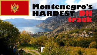
trail: Risan DH Track
8:16 |
6 |
Jul 3, 2022 , Kotor
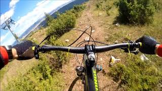
trail: Stuoc DH
1:35 |
950 |
Jan 17, 2018 , Zabljak
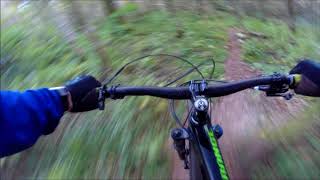
trail: Golesh Trail
6:16 |
527 |
Jan 17, 2018 , Kolashin
Recent Trail Reports
| status | trail | date | condition | info | user |
|---|---|---|---|---|---|
| Bosaca Zabljak | Jun 27, 2021 @ 11:28am Jun 27, 2021 | Dry | Mofeu | ||
| Access Bosaca Zabljak | Jun 27, 2021 @ 10:34am Jun 27, 2021 | Ideal | Mofeu | ||
| Stuoc DH Zabljak | Jun 24, 2021 @ 10:33am Jun 24, 2021 | Dry | Mofeu | ||
| Kotor DH Kotor | Jan 2, 2021 @ 2:06am Jan 2, 2021 | Dry | najdzell | ||
| Move Budva | Dec 27, 2020 @ 5:12am Dec 27, 2020 | Wet | najdzell |
Recent Comments
| username | type | title | comment | date | |
|---|---|---|---|---|---|
 | trail | Nice Trail, sometimes hard to find the track,... | Jun 14, 2022 @ 10:48am Jun 14, 2022 | ||
 | trail | it's all good. we rode it 2 weeks ago. Keep... | Oct 20, 2021 @ 8:51am Oct 20, 2021 | ||
| trail | I liked it. some parts are really hard but... | Oct 20, 2021 @ 8:49am Oct 20, 2021 | ||
 | trail | Hi, do you know if it's possible to rent a... | Sep 1, 2021 @ 7:54am Sep 1, 2021 | ||
 | trail | Nice singletrail. Upper part in a rut,... | Jun 27, 2021 @ 11:26am Jun 27, 2021 |
Activity Type Stats
| activitytype | trails | distance | descent | descent distance | total vertical | rating | global rank | state rank | photos | reports | routes | ridelogs |
|---|---|---|---|---|---|---|---|---|---|---|---|---|
| Mountain Bike | 26 | 69 miles | 32,303 ft | 42 miles | 6,752 ft | #97 | 69 | 8 | 1 | 935 | ||
| E-Bike | 5 | 20 miles | 6,316 ft | 9 miles | 3,422 ft | #67 | 5 | 17 | ||||
| Hike | 29 | 76 miles | 33,320 ft | 43 miles | 6,752 ft | #88 | 8 | 128 | ||||
| Trail Running | 29 | 76 miles | 33,320 ft | 43 miles | 6,752 ft | #88 | 8 | 1 | ||||
| Horse | 3 | 8 miles | 945 ft | 1 mile | 3,353 ft | |||||||
| Dirtbike/Moto | 1 | 4 miles | 82 ft | 2,113 ft | 1,184 ft | |||||||
| Observed Trials | 1 | 4 miles | 82 ft | 2,113 ft | 1,184 ft | |||||||
| ATV/ORV/OHV | 1 | 4 miles | 82 ft | 2,113 ft | 1,184 ft | |||||||
| Snowmobile | 1 | 4 miles | 82 ft | 2,113 ft | 1,184 ft | |||||||
| Snowshoe | 1 | 1 mile | 784 ft | 3,415 ft | 597 ft |
- By StuHolley & contributors
- Admins: apply
- #11014 - 8,920 views
- montenegro activity log | embed map of Montenegro mountain bike trails |
-
- subscribe
- 3d map
Downloading of trail gps tracks in kml & gpx formats is enabled for Montenegro.
You must login to download files.