close
Trail Conditions
- Unknown
- Snow Groomed
- Snow Packed
- Snow Covered
- Snow Cover Inadequate
- Freeze/thaw Cycle
- Icy
- Prevalent Mud
- Wet
- Variable
- Ideal
- Dry
- Very Dry
Trail Flow (Ridden Direction)
Trailforks scans users ridelogs to determine the most popular direction each trail is ridden. A good flowing trail network will have most trails flowing in a single direction according to their intension.
The colour categories are based on what percentage of riders are riding a trail in its intended direction.
The colour categories are based on what percentage of riders are riding a trail in its intended direction.
- > 96%
- > 90%
- > 80%
- > 70%
- > 50%
- < 50%
- bi-directional trail
- no data
Trail Last Ridden
Trailforks scans ridelogs to determine the last time a trail was ridden.
- < 2 days
- < 1 week
- < 2 weeks
- < 1 month
- < 6 months
- > 6 months
Trail Ridden Direction
The intended direction a trail should be ridden.
- Downhill Only
- Downhill Primary
- Both Directions
- Uphill Primary
- Uphill Only
- One Direction
Contribute Details
Colors indicate trail is missing specified detail.
- Description
- Photos
- Description & Photos
- Videos
Trail Popularity ?
Trailforks scans ridelogs to determine which trails are ridden the most in the last 9 months.
Trails are compared with nearby trails in the same city region with a possible 25 colour shades.
Think of this as a heatmap, more rides = more kinetic energy = warmer colors.
- most popular
- popular
- less popular
- not popular
ATV/ORV/OHV Filter
Max Vehicle Width
inches
Radar Time
x
Activity Recordings
Trailforks users anonymized public ridelogs from the past 6 months.
- mountain biking recent
- mountain biking (>6 month)
- hiking (1 year)
- moto (1 year)
Activity Recordings
Trailforks users anonymized public skilogs from the past 12 months.
- Downhill Ski
- Backcountry Ski
- Nordic Ski
Jump Magnitude Heatmap
Heatmap of where riders jump on trails. Zoom in to see individual jumps, click circles to view jump details.
Trails Deemphasized
Trails are shown in grey.
Only show trails with NO bikes.
Save the current map location and zoom level as your default home location whenever this page is loaded.
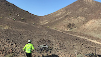
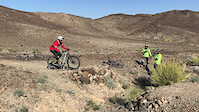
SaveThe jewel of the gulf region Trails are generally rocky or dusty, particularly in the north where it doesn't rain.
Region Supporters & Maintainers
![]()
Oman TrailbuildersBuilder
Stats
- Avg Trail Rating
- Trails (view details)
- 229
- Trails Mountain Bike
- 196
- Trails E-Bike
- 55
- Trails Hike
- 212
- Trails Trail Running
- 207
- Trails Horse
- 5
- Trails Dirtbike/Moto
- 7
- Total Distance
- 430 miles
- Total Descent
- 67,482 ft
- Total Vertical
- 7,867 ft
- Highest Trailhead
- 7,871 ft
- Reports
- 447
- Photos
- 389
- Ridden Counter
- 5,140
Popular Trail Networks
view all areas »Sub Regions
Popular Oman Mountain Biking Trails
| status | title | difficulty | rating |
|---|---|---|---|
| Tomb Raider Al Khoud | |||
| Lara's Linkup Al Khoud | |||
| Home Invader Al Khoud | |||
| HI-High-Hill Al Khoud | |||
| Wonderful Winding Wadi Al Khoud | |||
| Bousher Mount Everest Bousher | |||
| Jurassic Park Al Khoud | |||
| Al Nahal Bees Al Khoud | |||
| Isla Nublar Way Al Khoud | |||
| Jurassic Park Exit Al Khoud | |||
| Don't Black Down Hamriya | |||
| Hidden Views Trail Muscat | |||
| Spark Bousher | |||
| Al Nahal Bees Entry Al Khoud | |||
| The Ridge Trail Hamriya |
Oman Mountain Bike Routes
| title | rating | distance |
|---|---|---|
| Khoud you believe it? Al Khoud | 20 miles | |
| HVT Al Khoud | 3 miles | |
| BNA Route Jiffnain Trails | 2 miles | |
| Jurassic World Loop Al Khoud | 10 miles | |
| Bousher Mount Everest MegaPro Bousher | 1 mile | |
| Al Khoud Trail Centre Al Khoud | 16 miles | |
| Hamriyeah World Hamriya | 5 miles | |
| Hamriyeah World Hamriya | 5 miles | |
| Sa'al Super Singletrack Loop Ghala | 12 miles | |
| Jurassic World Route Al Khoud | 5 miles |
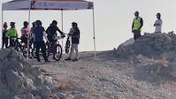
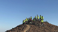
Photos of Oman Mountain Bike
trail: Rise Above Downhill 2
17 |
Mar 16, 2022 @ 3:08am
Mar 16, 2022
trail: Don't Black Down
48 |
Mar 15, 2022 @ 3:23am
Mar 15, 2022
trail: The Ridge Trail
52 |
Mar 15, 2022 @ 3:21am
Mar 15, 2022
trail: Don't Black Down
58 |
Mar 15, 2022 @ 3:20am
Mar 15, 2022
trail: G-Force
53 |
Mar 15, 2022 @ 3:04am
Mar 15, 2022
trail: Don't Black Down
27 |
Mar 15, 2022 @ 3:03am
Mar 15, 2022
trail: Trailz in da Khoud 1
191 |
Dec 17, 2017 @ 8:35pm
Dec 17, 2017
trail: Trailz in da Khoud 1
49 |
Oct 27, 2017 @ 10:14am
Oct 27, 2017Videos of Oman Mountain Bike
trail: Rise Above Downhill 2
25 |
Mar 16, 2022
trail: Sharqiya lines
4 |
Feb 22, 2022
trail: Roy's Jumpline
4 |
Feb 22, 2022
trail: Sharqiya lines
6 |
Feb 22, 2022
trail: Sharqiya lines
15 |
Feb 8, 2021
trail: Sharqiya lines
5 |
Feb 8, 2021
trail: Sharqiya lines
8 |
Feb 8, 2021
trail: Hidden Views Trail
1:06 |
|
Oct 4, 2020
Recent Trail Reports
| status | trail | date | condition | info | user |
|---|---|---|---|---|---|
| Sharqiya lines Ibra | Feb 22, 2022 @ 2:16am Feb 22, 2022 | Dry | Roysluneta | ||
| Rise Above Downhill 2 Hamriya | Feb 20, 2022 @ 9:33pm Feb 20, 2022 | Ideal | joebunn OTB | ||
| G-Force Hamriya | Feb 20, 2022 @ 9:22pm Feb 20, 2022 | Dry | joebunn OTB | ||
| Penny's Way Hamriya | Feb 20, 2022 @ 9:21pm Feb 20, 2022 | Dry | joebunn OTB | ||
| Don't Black Down Hamriya | Feb 20, 2022 @ 9:19pm Feb 20, 2022 | Ideal | joebunn OTB | ||
| Al Nahal Bees Al Khoud | Jan 5, 2022 @ 4:35am Jan 5, 2022 | Dry | hamed-alwaalmtbteam | ||
| Rise Above Climb Up Hamriya | Dec 16, 2021 @ 7:23pm Dec 16, 2021 | Ideal | hamed-alwaalmtbteam | ||
| Hamri-yeah Enduro start Hamriya | Dec 16, 2021 @ 7:23pm Dec 16, 2021 | Unknown | hamed-alwaalmtbteam | ||
| The Ridge Trail Penny to Hamri-Yeah Hamriya | Dec 16, 2021 @ 7:23pm Dec 16, 2021 | Dry | hamed-alwaalmtbteam | ||
| The Ridge Trail Hamriya | Dec 16, 2021 @ 7:23pm Dec 16, 2021 | Dry | hamed-alwaalmtbteam |
Recent Comments
| username | type | title | comment | date | |
|---|---|---|---|---|---|
 | report | My bad, edited out the roots hahaha | Mar 2, 2021 @ 8:02pm Mar 2, 2021 | ||
 | report | Roots? I'll be there shortly to ride them! | Mar 2, 2021 @ 7:58am Mar 2, 2021 | ||
 | trail | Is facing the sun an issue when heading... | Jan 30, 2021 @ 1:21am Jan 30, 2021 | ||
| report | Excellent job appreciate the hard work :) | Nov 26, 2020 @ 12:10am Nov 26, 2020 | ||
| report | Awesome. We'll update the map when the new... | Nov 6, 2020 @ 8:38am Nov 6, 2020 |
Activity Type Stats
| activitytype | trails | distance | descent | descent distance | total vertical | rating | global rank | state rank | photos | reports | routes | ridelogs |
|---|---|---|---|---|---|---|---|---|---|---|---|---|
| Mountain Bike | 196 | 336 miles | 38,212 ft | 142 miles | 7,408 ft | #39 | 372 | 445 | 53 | 14,572 | ||
| E-Bike | 55 | 148 miles | 15,135 ft | 59 miles | 7,408 ft | #64 | 3 | 336 | 2 | 68 | ||
| Hike | 212 | 411 miles | 64,186 ft | 174 miles | 7,867 ft | #38 | 13 | 431 | 11 | 682 | ||
| Trail Running | 207 | 405 miles | 61,506 ft | 171 miles | 7,867 ft | #38 | 431 | 11 | 107 | |||
| Horse | 5 | 14 miles | 1,946 ft | 5 miles | 1,634 ft | 110 | ||||||
| Dirtbike/Moto | 7 | 22 miles | 1,955 ft | 6 miles | 1,634 ft | 1 | 109 | 9 |
- By joebunn
 OTB & contributors
 - Admins: joebunn, whitedp
- #8668 - 15,293 views
- oman activity log | embed map of Oman mountain bike trails | oman mountain biking points of interest
-
- subscribe
- 3d map
Downloading of trail gps tracks in kml & gpx formats is enabled for Oman.
You must login to download files.