close
Trail Conditions
- Unknown
- Snow Groomed
- Snow Packed
- Snow Covered
- Snow Cover Inadequate
- Freeze/thaw Cycle
- Icy
- Prevalent Mud
- Wet
- Variable
- Ideal
- Dry
- Very Dry
Trail Flow (Ridden Direction)
Trailforks scans users ridelogs to determine the most popular direction each trail is ridden. A good flowing trail network will have most trails flowing in a single direction according to their intension.
The colour categories are based on what percentage of riders are riding a trail in its intended direction.
The colour categories are based on what percentage of riders are riding a trail in its intended direction.
- > 96%
- > 90%
- > 80%
- > 70%
- > 50%
- < 50%
- bi-directional trail
- no data
Trail Last Ridden
Trailforks scans ridelogs to determine the last time a trail was ridden.
- < 2 days
- < 1 week
- < 2 weeks
- < 1 month
- < 6 months
- > 6 months
Trail Ridden Direction
The intended direction a trail should be ridden.
- Downhill Only
- Downhill Primary
- Both Directions
- Uphill Primary
- Uphill Only
- One Direction
Contribute Details
Colors indicate trail is missing specified detail.
- Description
- Photos
- Description & Photos
- Videos
Trail Popularity ?
Trailforks scans ridelogs to determine which trails are ridden the most in the last 9 months.
Trails are compared with nearby trails in the same city region with a possible 25 colour shades.
Think of this as a heatmap, more rides = more kinetic energy = warmer colors.
- most popular
- popular
- less popular
- not popular
ATV/ORV/OHV Filter
Max Vehicle Width
inches
Radar Time
x
Activity Recordings
Trailforks users anonymized public ridelogs from the past 6 months.
- mountain biking recent
- mountain biking (>6 month)
- hiking (1 year)
- moto (1 year)
Activity Recordings
Trailforks users anonymized public skilogs from the past 12 months.
- Downhill Ski
- Backcountry Ski
- Nordic Ski
Jump Magnitude Heatmap
Heatmap of where riders jump on trails. Zoom in to see individual jumps, click circles to view jump details.
Trails Deemphasized
Trails are shown in grey.
Only show trails with NO bikes.
Save the current map location and zoom level as your default home location whenever this page is loaded.
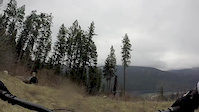
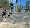
SaveThis area is all about rock faces with Newtsac being the most notorious trail.
Primary Trail Type: All-Mountain & Downhill
Shuttleable: YES
 google parking directions
 Activities Click to view
- Mountain Bike
41 trails
- Hike
23 trails
- Trail Running
23 trails
Region Details
- 17
- 1
- 6
- 12
- 5
Region Status
Caution as of Jul 2, 2022Local Trail Association
Stats
- Avg Trail Rating
- Trails (view details)
- 42
- Trails Mountain Bike
- 41
- Trails Hike
- 23
- Trails Trail Running
- 23
- Total Distance
- 50 miles
- Total Descent
- 18,361 ft
- Total Vertical
- 5,289 ft
- Highest Trailhead
- 7,062 ft
- Reports
- 464
- Photos
- 494
- Ridden Counter
- 6,896
Popular Nelson's North Shore Mountain Biking Trails
Nelson's North Shore Mountain Bike Routes
| title | rating | distance |
|---|---|---|
| Glacier Fresh | 11 miles | |
| Hitman Pedal access route | 12 miles | |
| Short Doz Slabs Loop | 1 mile | |
| 5 mile Nelson's North Shore All-Mountain Ride | popular ridelog | 5 miles |
| 4 mile Nelson's North Shore Ride | popular ridelog | 4 miles |
| 6 mile Nelson's North Shore Ride | popular ridelog | 6 miles |
| 6 mile Nelson's North Shore Ride | popular ridelog | 6 miles |
| 6 mile Nelson's North Shore Ride | popular ridelog | 6 miles |
| 8 mile Nelson's North Shore Ride | popular ridelog | 8 miles |
| 6 mile Nelson's North Shore All-Mountain Ride | popular ridelog | 6 miles |
Photos of Nelson's North Shore Mountain Bike
trail: Doz Slabs
317 |
Sep 3, 2018 @ 10:10pm
Sep 3, 2018
trail: Doz Slabs
251 |
Sep 3, 2018 @ 10:10pm
Sep 3, 2018
trail: Nooner
341 |
Jun 19, 2018 @ 11:59am
Jun 19, 2018
trail: Ledges
381 |
Nov 30, 2014 @ 5:51pm
Nov 30, 2014
trail: Slabalanche
531 |
Oct 20, 2014 @ 1:04pm
Oct 20, 2014
trail: Newtsac
1,024 |
Aug 11, 2014 @ 9:30am
Aug 11, 2014
trail: Newtsac
2,067 | | 1 comments
May 3, 2013 @ 6:18pm
May 3, 2013
trail: Slabalanche
2,734 | | 1 comments
Sep 28, 2011 @ 10:50am
Sep 28, 2011Videos of Nelson's North Shore Mountain Bike

trail: Newtsac
24 |
Oct 30, 2020

trail: Slabalanche
0:10 |
134 |
Sep 25, 2020

trail: Nooner
2:43 |
347 |
Apr 28, 2019
trail: Nooner
4:06 |
590 |
Dec 10, 2017
trail: Nooner
10:46 |
142 |
Jul 25, 2017
trail: Morning Sickness
4:18 |
497 |
May 21, 2017
trail: Nooner
3:19 |
480 |
May 6, 2017
trail: Morning Sickness
4:01 |
284 |
Apr 21, 2017
Recent Trail Reports
| status | trail | date | condition | info | user |
|---|---|---|---|---|---|
| West Kokanee Face FSR | Jul 1, 2022 @ 8:56am Jul 1, 2022 | Ideal | canadaka Trailforks | ||
| West Kokanee Creek Recreation Trail | Jul 1, 2022 @ 8:56am Jul 1, 2022 | Dry | canadaka Trailforks | ||
| West Kokanee Face FSR | Jul 1, 2022 @ 8:56am Jul 1, 2022 | Variable | canadaka Trailforks | ||
| FSR | Jul 1, 2022 @ 8:56am Jul 1, 2022 | Ideal | canadaka Trailforks | ||
| Lwr/Upper Hitman access trail | Jul 1, 2022 @ 8:56am Jul 1, 2022 | Dry | canadaka Trailforks | ||
| Hitman | Jul 1, 2022 @ 8:56am Jul 1, 2022 | Ideal | canadaka Trailforks | ||
| Doz Hitman Connector | Jul 1, 2022 @ 8:56am Jul 1, 2022 | Ideal | canadaka Trailforks | ||
| Goosebumps (easier option) | Jul 1, 2022 @ 8:56am Jul 1, 2022 | Ideal | canadaka Trailforks | ||
| Nooner | Jul 1, 2022 @ 8:56am Jul 1, 2022 | Dry | canadaka Trailforks | ||
| Access | Jul 1, 2022 @ 8:56am Jul 1, 2022 | Ideal | canadaka Trailforks |
Activity Feed
| username | action | type | title | date | |
|---|---|---|---|---|---|
 | twowheeledchaos | comment | trail | Slabalanche | Jul 5, 2022 @ 9:09pm 6 hours |
| twowheeledchaos | ridden | trail | Slabalanche | Jul 5, 2022 @ 9:06pm 7 hours |
| twowheeledchaos | vote | trail | Slabalanche | Jul 5, 2022 @ 9:05pm 7 hours |
 | 1partatatime | add | photo | in Penticton, British Columbia, Canada and 1 more | Jul 5, 2022 @ 8:57pm 7 hours |
 | Fanderson | ridden | trail | Glade Runner | Jul 5, 2022 @ 8:05pm 8 hours |
Recent Comments
| username | type | title | comment | date | |
|---|---|---|---|---|---|
| trail | One double black slab to rut roll pretty much... | Jul 5, 2022 @ 9:09pm 6 hours | ||
| trail | Meh, it's an ok trail by most standards but... | Jul 5, 2022 @ 8:02pm 8 hours | ||
| trail | Must do trail of you're into tech gnar and slabs! | Jul 5, 2022 @ 8:01pm 8 hours | ||
 | report | It's clear now | Apr 9, 2022 @ 5:02pm Apr 9, 2022 | ||
 | trail | Will ride again… and again. | Mar 31, 2022 @ 9:15am Mar 31, 2022 |
Nearby Areas
| name | distance | ||||
|---|---|---|---|---|---|
| Svoboda Road | 5 | 15 | 3 | 8 km | |
| Shannon Pass | 1 | 1 | 2 | 8.2 km | |
| Mountain Station | 1 | 5 | 17 | 10.4 km | |
| Whitewater Ski Resort | 1 | 11.8 km | |||
| Pilot Point Peninsula | 6 | 6 | 1 | 12.8 km |
Local Badges
-

Completionist0 awarded
Local Products
Activity Type Stats
| activitytype | trails | distance | descent | descent distance | total vertical | rating | global rank | state rank | photos | reports | routes | ridelogs |
|---|---|---|---|---|---|---|---|---|---|---|---|---|
| Mountain Bike | 41 | 49 miles | 18,232 ft | 21 miles | 5,289 ft | #967 | #103 | 494 | 464 | 3 | 3,333 | |
| Hike | 23 | 35 miles | 4,423 ft | 9 miles | 5,289 ft | #2,781 | #173 | 316 | 66 | |||
| Trail Running | 23 | 35 miles | 4,423 ft | 9 miles | 5,289 ft | #2,783 | #167 | 316 | 12 |
- By canadaka
 Trailforks & contributors
 - Admins: KCTS, NCC, FOPRTS, kwl1
- #1983 - 15,115 views
- nelson's north shore activity log | embed map of Nelson's North Shore mountain bike trails | nelson's north shore mountain biking points of interest
Downloading of trail gps tracks in kml & gpx formats is disabled for Nelson's North Shore.