close
Trail Conditions
- Unknown
- Snow Groomed
- Snow Packed
- Snow Covered
- Snow Cover Inadequate
- Freeze/thaw Cycle
- Icy
- Prevalent Mud
- Wet
- Variable
- Ideal
- Dry
- Very Dry
Trail Flow (Ridden Direction)
Trailforks scans users ridelogs to determine the most popular direction each trail is ridden. A good flowing trail network will have most trails flowing in a single direction according to their intension.
The colour categories are based on what percentage of riders are riding a trail in its intended direction.
The colour categories are based on what percentage of riders are riding a trail in its intended direction.
- > 96%
- > 90%
- > 80%
- > 70%
- > 50%
- < 50%
- bi-directional trail
- no data
Trail Last Ridden
Trailforks scans ridelogs to determine the last time a trail was ridden.
- < 2 days
- < 1 week
- < 2 weeks
- < 1 month
- < 6 months
- > 6 months
Trail Ridden Direction
The intended direction a trail should be ridden.
- Downhill Only
- Downhill Primary
- Both Directions
- Uphill Primary
- Uphill Only
- One Direction
Contribute Details
Colors indicate trail is missing specified detail.
- Description
- Photos
- Description & Photos
- Videos
Trail Popularity ?
Trailforks scans ridelogs to determine which trails are ridden the most in the last 9 months.
Trails are compared with nearby trails in the same city region with a possible 25 colour shades.
Think of this as a heatmap, more rides = more kinetic energy = warmer colors.
- most popular
- popular
- less popular
- not popular
ATV/ORV/OHV Filter
Max Vehicle Width
inches
Radar Time
x
Activity Recordings
Trailforks users anonymized public ridelogs from the past 6 months.
- mountain biking recent
- mountain biking (>6 month)
- hiking (1 year)
- moto (1 year)
Activity Recordings
Trailforks users anonymized public skilogs from the past 12 months.
- Downhill Ski
- Backcountry Ski
- Nordic Ski
Jump Magnitude Heatmap
Heatmap of where riders jump on trails. Zoom in to see individual jumps, click circles to view jump details.
Trails Deemphasized
Trails are shown in grey.
Only show trails with NO bikes.
Save the current map location and zoom level as your default home location whenever this page is loaded.
Save
No description for South Lake Tahoe has been added yet!
Login or register to submit one.
Activities Click to view
- Mountain Bike
121 trails
- E-Bike
14 trails
- Hike
135 trails
- Trail Running
134 trails
- Horse
108 trails
- Dirtbike/Moto
11 trails
- ATV/ORV/OHV
10 trails
Region Details
- 15
- 6
- 61
- 25
- 10
Region Status
Closed as of Aug 23, 2021Stats
- Avg Trail Rating
- Trails (view details)
- 233
- Trails Mountain Bike
- 121
- Trails E-Bike
- 14
- Trails Hike
- 135
- Trails Trail Running
- 134
- Trails Horse
- 108
- Trails Dirtbike/Moto
- 11
- Trails Observed Trials
- 3
- Trails ATV/ORV/OHV
- 10
- Trails Downhill Ski
- 103
- Total Distance
- 221 miles
- Total Descent
- 64,495 ft
- Total Vertical
- 4,645 ft
- Highest Trailhead
- 10,877 ft
- Reports
- 1,365
- Photos
- 459
- Ridden Counter
- 44,172
Sub Regions
-
Corral
- 3
- 4
- 2
-
Fallen Leaf
- 1
- 5
- 1
-
Freel High Country
- 5
- 5
-
Hartoonian Trails
- 24
-
Powerline
- 4
- 3
- 1
-
SLT Urban Trails
- 4
- 14
- 1
-
Tahoe Mountain
- 1
- 11
- 11
- 1
Popular South Lake Tahoe Mountain Biking Trails
South Lake Tahoe Mountain Bike Routes
| title | rating | distance |
|---|---|---|
| TAMBA Rose to Toads | 62 miles | |
| Mr. Toads Loop | 19 miles | |
| Tahoe Mountain / Angora Ridge Loop | 7 miles | |
| Cold Creek-Star Lake-Freel Peak-Mr. Toad's | 26 miles | |
| Power Loop | 7 miles | |
| Iron Butterfly | 20 miles | |
| Waterhouse Loop | 10 miles | |
| Tour of Tahoe Mountain | 12 miles | |
| Waterhouse Peak Loop | 10 miles | |
| Spooner to Stateline | 20 miles |
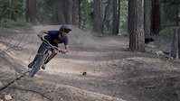
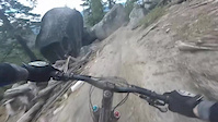
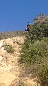
Photos of South Lake Tahoe Mountain Bike
trail: Valley View Trail
10 |
May 31, 2022 @ 10:51am
May 31, 2022
trail: Corral Trail (Upper)
18 |
May 31, 2022 @ 10:48am
May 31, 2022
trail: Armstrong Connector Trail
32 |
May 6, 2022 @ 8:04am
May 6, 2022
trail: Armstrong Connector Trail
46 |
May 6, 2022 @ 8:04am
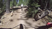
May 6, 2022Videos of South Lake Tahoe Mountain Bike
trail: Corral Trail (Lower)
1:20 |
430 |
Aug 15, 2017
0:40 |
70 |
Mar 16, 2017
1:00 |
282 |
Nov 30, 2016
1:00 |
227 |
Nov 30, 2016
trail: Armstrong Pass Trail
1:00 |
206 |
Nov 7, 2016
trail: Rock Garden (17E80B)
0:19 |
285 |
Aug 28, 2016
trail: Corral Trail (Lower)
2:00 |
246 |
Aug 3, 2016
trail: Armstrong Connector Trail
4:35 |
81 |
Jul 13, 2016
Current Trail Warnings
| status | trail | date | condition | user | info |
|---|---|---|---|---|---|
| Columbine Trail Connector | Jun 11, 2022 @ 3:50pm Jun 11, 2022 | Dry | scott-ws | Logging operations blocking trail. Trail... |
Recent Trail Reports
| status | trail | date | condition | info | user |
|---|---|---|---|---|---|
| Tahoe Rim Trail (High Meadows) | Jul 4, 2022 @ 2:11pm 2 days | Dry | ealberton | ||
| Star Lake Trail | Jul 4, 2022 @ 2:11pm 2 days | Dry | ealberton | ||
| Tahoe Rim Trail (Freel Meadows) | Jul 3, 2022 @ 7:08am 3 days | Dry | fpecan | ||
| Tahoe Rim Trail (Tucker Flat) | Jun 29, 2022 @ 10:55am Jun 29, 2022 | Ideal | javadown1969 | ||
| Saxon Creek Trail (Mr. Toad's Wild Ride) | Jun 29, 2022 @ 10:55am Jun 29, 2022 | Dry | javadown1969 | ||
| Saxon Creek Road | Jun 29, 2022 @ 10:55am Jun 29, 2022 | Ideal | javadown1969 | ||
| Lake Tahoe Boulevard Bike Path | Jun 24, 2022 @ 11:28am Jun 24, 2022 | Ideal | scott-ws | ||
| High School Double Track | Jun 24, 2022 @ 11:28am Jun 24, 2022 | Dry | scott-ws | ||
| Tahoe Mountain Trail (North Section) | Jun 24, 2022 @ 11:28am Jun 24, 2022 | Dry | scott-ws | ||
| Sawmill Connector | Jun 24, 2022 @ 11:28am Jun 24, 2022 | Dry | scott-ws |
Activity Feed
| username | action | type | title | date | |
|---|---|---|---|---|---|
 | judge-shredd | wishlist | route | Mr. Toads Loop | Jul 5, 2022 @ 3:29pm 12 hours |
 | Joeramos | wishlist | route | Mr. Toads Loop | Jul 5, 2022 @ 9:23am 18 hours |
| plockett81 | wishlist | route | Mr. Toads Loop | Jul 5, 2022 @ 8:23am 19 hours |
 | abeckstead | wishlist | route | TAMBA Rose to Toads | Jul 5, 2022 @ 5:57am 22 hours |
| HannahhQe1mk | wishlist | route | Cold Creek-Star Lake-Freel Peak-Mr. Toad's | Jul 4, 2022 @ 8:17pm 1 day |
Recent Comments
| username | type | title | comment | date | |
|---|---|---|---|---|---|
 | trail | Whoever keeps cutting B-Lines in the trail... | Jul 2, 2022 @ 1:41am Jul 2, 2022 | ||
| trail | Look o | May 29, 2022 @ 9:41pm May 29, 2022 | ||
| trail | Tried to ride this Sunday. Could only go... | May 18, 2022 @ 2:41pm May 18, 2022 | ||
| trail | Did this trail in the mid eighties. On... | May 14, 2022 @ 8:43pm May 14, 2022 | ||
| trail | 2 on-foot-passable patches of snow up top and... | May 4, 2022 @ 9:29am May 4, 2022 |
Local Badges
-

Big Ride 30k2,021 awarded -

10 Blue Trails317 awarded -

Epic Ride Descent 2k100 awarded -

Climbing 10k Badge116 awarded -

Epic Ride Climb 2k83 awarded -

Descent 100k Badge4 awarded
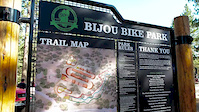
Bike & Skill Parks
| name | type | city | rating |
|---|---|---|---|
| Heavenly Mountain Resort | bike park | South Lake Tahoe | |
| Bijou Bike Park | skill park | South Lake Tahoe |
Activity Type Stats
| activitytype | trails | distance | descent | descent distance | total vertical | rating | global rank | state rank | photos | reports | routes | ridelogs |
|---|---|---|---|---|---|---|---|---|---|---|---|---|
| Mountain Bike | 121 | 157 miles | 19,160 ft | 53 miles | 3,497 ft | #202 | #95 | 452 | 1,359 | 24 | 20,372 | |
| E-Bike | 14 | 21 miles | 2,579 ft | 9 miles | 1,581 ft | #189 | #54 | 2 | 1,079 | 2 | 831 | |
| Hike | 135 | 176 miles | 20,791 ft | 57 miles | 4,646 ft | #147 | #83 | 5 | 1,352 | 1 | 1,696 | |
| Trail Running | 134 | 175 miles | 20,771 ft | 57 miles | 3,497 ft | #149 | #83 | 1,351 | 1 | 613 | ||
| Horse | 108 | 154 miles | 17,103 ft | 47 miles | 3,491 ft | #11 | #10 | 887 | 1 | 2 | ||
| Dirtbike/Moto | 11 | 13 miles | 1,952 ft | 6 miles | 1,401 ft | #5 | #5 | 730 | 1 | 15 | ||
| Observed Trials | 3 | 4 miles | 699 ft | 2 miles | 646 ft | 16 | 2 | |||||
| ATV/ORV/OHV | 10 | 13 miles | 1,552 ft | 5 miles | 1,401 ft | #1 | #1 | 714 | 3 | |||
| Downhill Ski | 103 | 45 miles | 43,704 ft | 44 miles | 3,294 ft | 1,832 |
- By TahoeOrange & contributors
- Admins: TAMBA, TRTA, SBTS, TheAngryTomato
- #5400 - 39,317 views
- south lake tahoe activity log | embed map of South Lake Tahoe mountain bike trails | south lake tahoe mountain biking points of interest
Downloading of trail gps tracks in kml & gpx formats is enabled for South Lake Tahoe.
You must login to download files.