close
Trail Conditions
- Unknown
- Snow Groomed
- Snow Packed
- Snow Covered
- Snow Cover Inadequate
- Freeze/thaw Cycle
- Icy
- Prevalent Mud
- Wet
- Variable
- Ideal
- Dry
- Very Dry
Trail Flow (Ridden Direction)
Trailforks scans users ridelogs to determine the most popular direction each trail is ridden. A good flowing trail network will have most trails flowing in a single direction according to their intension.
The colour categories are based on what percentage of riders are riding a trail in its intended direction.
The colour categories are based on what percentage of riders are riding a trail in its intended direction.
- > 96%
- > 90%
- > 80%
- > 70%
- > 50%
- < 50%
- bi-directional trail
- no data
Trail Last Ridden
Trailforks scans ridelogs to determine the last time a trail was ridden.
- < 2 days
- < 1 week
- < 2 weeks
- < 1 month
- < 6 months
- > 6 months
Trail Ridden Direction
The intended direction a trail should be ridden.
- Downhill Only
- Downhill Primary
- Both Directions
- Uphill Primary
- Uphill Only
- One Direction
Contribute Details
Colors indicate trail is missing specified detail.
- Description
- Photos
- Description & Photos
- Videos
Trail Popularity ?
Trailforks scans ridelogs to determine which trails are ridden the most in the last 9 months.
Trails are compared with nearby trails in the same city region with a possible 25 colour shades.
Think of this as a heatmap, more rides = more kinetic energy = warmer colors.
- most popular
- popular
- less popular
- not popular
ATV/ORV/OHV Filter
Max Vehicle Width
inches
Radar Time
x
Activity Recordings
Trailforks users anonymized public ridelogs from the past 6 months.
- mountain biking recent
- mountain biking (>6 month)
- hiking (1 year)
- moto (1 year)
Activity Recordings
Trailforks users anonymized public skilogs from the past 12 months.
- Downhill Ski
- Backcountry Ski
- Nordic Ski
Jump Magnitude Heatmap
Heatmap of where riders jump on trails. Zoom in to see individual jumps, click circles to view jump details.
Trails Deemphasized
Trails are shown in grey.
Only show trails with NO bikes.
Save the current map location and zoom level as your default home location whenever this page is loaded.
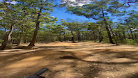
SaveThis National Park has a mixture of eucalypt, pine, and sub tropical pockets of bush make for constantly changing scenery while riding here. Tewantin has some aggressive climbs ... and great multitrack downhills also.
Primary Trail Type: Cross-Country
AKA: Wooroi
Land Status: National Park
 google parking directions
Links
Activities Click to view
- Mountain Bike
28 trails
- E-Bike
28 trails
- Hike
21 trails
- Trail Running
21 trails
Region Details
- 8
- 1
- 9
- 7
- 3
Region Status
Open as of Mar 16, 2022Local Trail Association
Stats
- Avg Trail Rating
- Trails (view details)
- 28
- Trails Mountain Bike
- 28
- Trails E-Bike
- 28
- Trails Hike
- 21
- Trails Trail Running
- 21
- Total Distance
- 21 miles
- Total Descent
- 2,124 ft
- Total Vertical
- 465 ft
- Highest Trailhead
- 482 ft
- Reports
- 482
- Photos
- 62
- Ridden Counter
- 19,733
Popular Tewantin National Park Mountain Biking Trails
Tewantin National Park Mountain Bike Routes
| title | rating | distance |
|---|---|---|
| Milk Maid Loop | 2 miles |
Photos of Tewantin National Park Mountain Bike
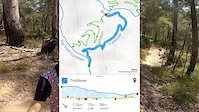
trail: Waterfall
47 |
Jan 20, 2022 @ 11:48pm
Jan 20, 2022
trail: Glider
40 |
Aug 27, 2021 @ 8:06pm
Aug 27, 2021
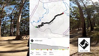
trail: Milkmaid
86 |
Apr 11, 2021 @ 8:23pm
Apr 11, 2021
trail: Milkmaid
74 |
Apr 11, 2021 @ 8:23pm
Apr 11, 2021
trail: Hovea
62 |
Apr 1, 2021 @ 4:18am
Apr 1, 2021
trail: Gyndier Drive
107 |
Mar 5, 2021 @ 6:06pm
Mar 5, 2021
trail: Gyndier Drive
53 |
Mar 5, 2021 @ 6:06pm
Mar 5, 2021
trail: Hovea First
56 |
Mar 5, 2021 @ 1:50am
Mar 5, 2021Videos of Tewantin National Park Mountain Bike

trail: Turn 10 (Quoll)
64 |
Feb 10, 2022
trail: Trailblazer
32 |
Feb 9, 2022
trail: Milkmaid
56 |
Feb 9, 2022
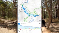
trail: Bloodwood
35 |
Feb 9, 2022

trail: Secrets
87 |
Oct 5, 2021
trail: Milkmaid
|
Sep 13, 2021

trail: Milkmaid
187 |
Mar 1, 2021

trail: Secrets
95 |
Mar 1, 2021
Recent Trail Reports
| status | trail | date | condition | info | user |
|---|---|---|---|---|---|
| Gyndier Drive | Jun 11, 2022 @ 4:05pm Jun 11, 2022 | Dry | drlilley | ||
| Turn 10 (Quoll) | Jun 11, 2022 @ 4:05pm Jun 11, 2022 | Variable | drlilley | ||
| Top Track (Lorikeet) | Jun 11, 2022 @ 4:05pm Jun 11, 2022 | Variable | drlilley | ||
| Trailblazer | Jun 11, 2022 @ 4:05pm Jun 11, 2022 | Variable | drlilley | ||
| Milkmaid | Apr 19, 2022 @ 5:44pm Apr 19, 2022 | Ideal | Alexcfq3Yb | ||
| Cross Cut | Apr 19, 2022 @ 5:44pm Apr 19, 2022 | Variable | Alexcfq3Yb | ||
| Glossy | Apr 19, 2022 @ 5:44pm Apr 19, 2022 | Ideal | Alexcfq3Yb | ||
| Hovea | Apr 19, 2022 @ 5:44pm Apr 19, 2022 | Ideal | Alexcfq3Yb | ||
| Indy | Apr 14, 2022 @ 3:06pm Apr 14, 2022 | Variable | Ironchef | ||
| Waterfall | Apr 14, 2022 @ 3:06pm Apr 14, 2022 | Variable | Ironchef |
Activity Feed
| username | action | type | title | date | |
|---|---|---|---|---|---|
 | mr-t-80 | wishlist | trail | Milkmaid | Jun 30, 2022 @ 10:22pm Jun 30, 2022 |
| mr-t-80 | ridden | trail | Bloodwood and 8 more | Jun 30, 2022 @ 10:22pm Jun 30, 2022 |
 | MTBER12 | ridden | trail | Waterfall and 9 more | Jun 26, 2022 @ 8:40pm Jun 26, 2022 |
| Wallyman747 | wishlist | region | Tewantin National Park | Jun 26, 2022 @ 8:01pm Jun 26, 2022 |
 | mttamog | wishlist | trail | Turn 10 (Quoll) | Jun 25, 2022 @ 7:32pm Jun 25, 2022 |
Recent Comments
| username | type | title | comment | date | |
|---|---|---|---|---|---|
| trail | Not good | Apr 10, 2022 @ 4:39am Apr 10, 2022 | ||
| trail | Not a proper track | Apr 10, 2022 @ 4:38am Apr 10, 2022 | ||
| trail | one of the best trails at Tewantin | Jan 31, 2022 @ 2:34am Jan 31, 2022 | ||
| trail | Easy gravel trail with small berms | Jan 21, 2022 @ 3:32pm Jan 21, 2022 | ||
| trail | Closed | Nov 26, 2021 @ 4:07pm Nov 26, 2021 |
Nearby Areas
| name | distance | ||||
|---|---|---|---|---|---|
| Eumundi Conservation Park | 4 | 6 km | |||
| Noosa Trail Network | 10 | 5 | 1 | 9.1 km | |
| Parklands | 11 | 34 | 4 | 13.1 km | |
| Mapleton National Park | 10 | 10 | 1 | 14.7 km | |
| Imbil State Forest | 20.7 km |
Local Badges
-

Completionist4 awarded
Activity Type Stats
| activitytype | trails | distance | descent | descent distance | total vertical | rating | global rank | state rank | photos | reports | routes | ridelogs |
|---|---|---|---|---|---|---|---|---|---|---|---|---|
| Mountain Bike | 28 | 21 miles | 2,123 ft | 8 miles | 466 ft | #210 | #24 | 62 | 482 | 1 | 11,914 | |
| E-Bike | 28 | 21 miles | 2,123 ft | 8 miles | 466 ft | #65 | #13 | 411 | 1 | 1,603 | ||
| Hike | 21 | 17 miles | 1,486 ft | 6 miles | 466 ft | #213 | #12 | 446 | 29 | |||
| Trail Running | 21 | 17 miles | 1,486 ft | 6 miles | 466 ft | #213 | #14 | 446 | 54 |
- By scta SCTA-AUS & contributors
- Admins: SCTA-AUS, BMTBC-SC, NTMTBC
- #5962 - 28,217 views
- tewantin national park activity log | embed map of Tewantin National Park mountain bike trails | tewantin national park mountain biking points of interest
Downloading of trail gps tracks in kml & gpx formats is enabled for Tewantin National Park.
You must login to download files.