Trailforks offers a special map tool for Search & Rescue (SAR) use.
http://www.trailforks.com/tracker/sar/
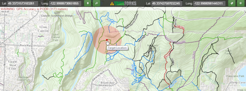
The app is a very simple fullpage map with Trailforks trails overlayed on roads & contours background. OpenStreetMap background is also available as it often has useful background detail.
The app shows the users location in the top left, you can press the "Follow" button to have your location continually update. A blue circle shows the estimated accuracy of your location from your GPS.
In the top right you can enter a target's location by manually entering the GPS Latitude & longitude acquired from the emergency dispatcher or the target directly.
You can also right click any spot on the map to manually set the target location. On mobile you press and hold to set the target.
You then press the green "Target Location" button to show that point on the map as a red dot.
If you don't know a targets exact lat/lon you can also use the search button to center the map on a specific trail the target might know, then right click a target point on that trail estimated the location.
This webapp works on a mobile phone.
In the future we will be adding features to this tool to use data from the Trailforks mobile map app to show a targets location with LIVE data.
http://www.trailforks.com/tracker/sar/
The app is a very simple fullpage map with Trailforks trails overlayed on roads & contours background. OpenStreetMap background is also available as it often has useful background detail.
The app shows the users location in the top left, you can press the "Follow" button to have your location continually update. A blue circle shows the estimated accuracy of your location from your GPS.
In the top right you can enter a target's location by manually entering the GPS Latitude & longitude acquired from the emergency dispatcher or the target directly.
You can also right click any spot on the map to manually set the target location. On mobile you press and hold to set the target.
You then press the green "Target Location" button to show that point on the map as a red dot.
If you don't know a targets exact lat/lon you can also use the search button to center the map on a specific trail the target might know, then right click a target point on that trail estimated the location.
This webapp works on a mobile phone.
In the future we will be adding features to this tool to use data from the Trailforks mobile map app to show a targets location with LIVE data.
- By canadaka
 Trailforks
 - #42 - 6,906 views