Supporters, Builders, Maintainers & Land Managers of Bobsled Trail

Telus
since 2014Sponsor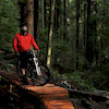
Patrick Podolski
since 2012Builder
DiggerBuilder- Joe WoywitkaBuilder
- past supporters

North Shore Bike Shop
2012 - 2013Sponsor- Liam Mulally
2012Sponsor
Bobsled Details
-
Activities
- Mountain Bike
-
Riding AreaMount Fromme
North Vancouver, British Columbia -
Difficulty Rating
-
Voted DifficultyBlue (36 votes)
-
Trail TypeMachine Groomed
-
Bike TypeDH, AM, Adaptive MTB
-
DirectionDownhill OnlyPopular direction shown
-
Physical RatingEasy
-
Trail VisibilityAlways easy to follow
-
Seasonyear round
-
Family FriendlyYes
-
Dogs AllowedYes
-
TTFs on TrailBerm, Bridge, Drop, Pump Track, Wallride
-
Ride in RainYes
-
Global Ranking#1 in Mountain Biking
-
Local Popularity100 in Mountain Biking
-
Land Manager
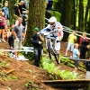
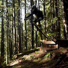
The first sanctioned new school flow trail, was rebuilt by the District of North Vancouver Trail crew in 2010. The proof is in the pudding of its popularity. On a nice day, you literally need to take a number for the flow show: big berms, small doubles and buff, undulating trail will have you climbing back up for another lap. Barely 10 minutes up Mountain Highway, it is easily accessed. It's importance lies not only in its popularity, but it proves new school trails can be built on the Shore.
Entirely pumped and some good carved berms. Has a wood wall ride, that must be ridden cautiously when wet.
Extensive work has been invested in the trail via the NSMBA TAP program including a significant reroute near the bottom to bring the grade in line with the goal of the trail to serve beginners.
Access Info
Accessed before the 2nd switchback, exits above the Baden Powell.
Adaptive Bike Info
Bridges with no railings
Local Trail Association
-
-

-
Please consider joining or donating to the local trail association to supportdonate to earn trail karma!
trail development & maintenance.
Traditionally Indigenous Territory
More Stats for Bobsled mountain bike trail trail
-
Altitude change-340 ft
-
Altitude min1,076 ft
-
Altitude max1,416 ft
-
Altitude start1,416 ft
-
Altitude end1,076 ft
-
Grade-13.7%
-
Grade max-38.5%
-
Grade min-2.4%
-
Distance down2,474 ft
-
Avg time00:04:32
-
Avg reverse time00:08:29
- view trail stats
- Unknown
- Snow Groomed
- Snow Packed
- Snow Covered
- Snow Cover Inadequate
- Freeze/thaw Cycle
- Icy
- Prevalent Mud
- Wet
- Variable
- Ideal
- Dry
- Very Dry
The colour categories are based on what percentage of riders are riding a trail in its intended direction.
- > 96%
- > 90%
- > 80%
- > 70%
- > 50%
- < 50%
- bi-directional trail
- no data
- < 2 days
- < 1 week
- < 2 weeks
- < 1 month
- < 6 months
- > 6 months
- Downhill Only
- Downhill Primary
- Both Directions
- Uphill Primary
- Uphill Only
- One Direction
- Description
- Photos
- Description & Photos
- Videos
- most popular
- popular
- less popular
- not popular
- mountain biking recent
- mountain biking (>6 month)
- hiking (1 year)
- moto (1 year)
- Downhill Ski
- Backcountry Ski
- Nordic Ski
Save the current map location and zoom level as your default home location whenever this page is loaded.
SaveBobsled Trail Reports
Recent Ridelog Activity on Trail
Past Week
- 172 rides
- 7 miles avg distance
6 Months
- 3,574 rides
- 7 miles avg distance
All
- 34,676 rides
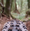
Technical Trail Features (TTF)
- Bridge
 Bridge
 - Bridge Bridge
- Bridge with Rolldown Bridge
- Drop Zone Drop
- Large Wood Berm Wallride
Photos
Routes with this trail
Trail Events
Trail Products
-
+ 0
 Nickapm
 brenthillier
 GreenJelly
(Oct 6, 2019 at 19:14)
GreenJelly
(Oct 6, 2019 at 19:14)
 PembyKonaRider
(Mar 16, 2019 at 15:11)
PembyKonaRider
(Mar 16, 2019 at 15:11)
 KevinStafford
(Oct 17, 2018 at 15:23)
KevinStafford
(Oct 17, 2018 at 15:23)
You know you'll be hungry later, and you'll regret not filling your plate with more of that crispy bacon.
Well bacon to a breakfast buffet is what Bob Sled is to Mt Fromme.
Go for seconds.
 timvan
(Jan 10, 2018 at 16:24)
timvan
(Jan 10, 2018 at 16:24)

 adriannorthshore
(Nov 9, 2014 at 17:44)
adriannorthshore
(Nov 9, 2014 at 17:44)
Videos


Nearby Trails
- Floppy Bunny 518 ft
- Decommisioned Trail 938 ft
- Bobsled Spur 1,660 ft
- Warden's Climb 1,693 ft
- Emergency Access 1,998 ft
- embed Bobsled trail on your website
- By canadaka
 Trailforks & contributors
 - #6 - 88,629 views
- subscribe
- login to download gpx or kml files.