close
Trail Conditions
- Unknown
- Snow Groomed
- Snow Packed
- Snow Covered
- Snow Cover Inadequate
- Freeze/thaw Cycle
- Icy
- Prevalent Mud
- Wet
- Variable
- Ideal
- Dry
- Very Dry
Trail Flow (Ridden Direction)
Trailforks scans users ridelogs to determine the most popular direction each trail is ridden. A good flowing trail network will have most trails flowing in a single direction according to their intension.
The colour categories are based on what percentage of riders are riding a trail in its intended direction.
The colour categories are based on what percentage of riders are riding a trail in its intended direction.
- > 96%
- > 90%
- > 80%
- > 70%
- > 50%
- < 50%
- bi-directional trail
- no data
Trail Last Ridden
Trailforks scans ridelogs to determine the last time a trail was ridden.
- < 2 days
- < 1 week
- < 2 weeks
- < 1 month
- < 6 months
- > 6 months
Trail Ridden Direction
The intended direction a trail should be ridden.
- Downhill Only
- Downhill Primary
- Both Directions
- Uphill Primary
- Uphill Only
- One Direction
Contribute Details
Colors indicate trail is missing specified detail.
- Description
- Photos
- Description & Photos
- Videos
Trail Popularity ?
Trailforks scans ridelogs to determine which trails are ridden the most in the last 9 months.
Trails are compared with nearby trails in the same city region with a possible 25 colour shades.
Think of this as a heatmap, more rides = more kinetic energy = warmer colors.
- most popular
- popular
- less popular
- not popular
ATV/ORV/OHV Filter
Max Vehicle Width
inches
Radar Time
x
Activity Recordings
Trailforks users anonymized public ridelogs from the past 6 months.
- mountain biking recent
- mountain biking (>6 month)
- hiking (1 year)
- moto (1 year)
Activity Recordings
Trailforks users anonymized public skilogs from the past 12 months.
- Downhill Ski
- Backcountry Ski
- Nordic Ski
Jump Magnitude Heatmap
Heatmap of where riders jump on trails. Zoom in to see individual jumps, click circles to view jump details.
Trails Deemphasized
Trails are shown in grey.
Only show trails with NO bikes.
Save the current map location and zoom level as your default home location whenever this page is loaded.
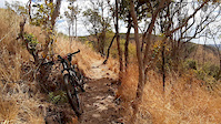
SaveFor more information on each ride area or trail, scroll down and click on any of the links. Most of the trails that have been mapped in Zambia at this stage, is in the Lusaka area.
If you are new to the Trailforks App, have a look at the Dummies Guide below for information on how to get started.
If you would like to map trails in your area, please message WillieJacobsz in the Trailforks messenger which can be found in the top right hand corner of your computer screen, to the right of the search bar, and I will help you get going.
On Trailforks Zambia is sub divided into its 10 official provinces as per the link below.
Links
- MTB Zambia Facebook Group
- Prozam MTB Supply Facebook Page
- Zambiaraces.com Facebook Group
- Zambia Provinces
Files
Region Supporters & Maintainers
Region Details
- 166
- 63
- 123
Stats
- Avg Trail Rating
- Trails (view details)
- 367
- Trails Mountain Bike
- 352
- Trails E-Bike
- 341
- Trails Hike
- 353
- Trails Trail Running
- 353
- Trails Dirtbike/Moto
- 14
- Total Distance
- 404 miles
- Total Descent Distance
- 191 miles
- Total Descent
- 34,505 ft
- Total Vertical
- 1,949 ft
- Highest Trailhead
- 4,586 ft
- Reports
- 17
- Photos
- 5
- Ridden Counter
- 377
Popular Trail Networks
view all areas »Sub Regions
- Central Province (1)
- Kabwe (1)
- Kabwe (1)
- Copperbelt Province (1)
- Kitwe (1)
- Kitwe (1)
- Eastern Province (1)
- Chipata (1)
- Chipata (1)
- Luapula Province (1)
- Mansa (1)
- Mansa (1)
- Lusaka Province (343)
- Muchinga Province (1)
- Chinsali (1)
- Chinsali (1)
- North Western Province (1)
- Solwezi (1)
- Solwezi (1)
- Northern Province (1)
- Kasama (1)
- Kasama (1)
- Southern Province (1)
- Livingstone (1)
- Livingstone (1)
- Western Province (1)
- Mongu (1)
- Mongu (1)
Popular Zambia Mountain Biking Trails
| status | title | difficulty | rating |
|---|---|---|---|
| Trail C2 Greater Lilayi Trail Network | |||
| Access Road Lilayi Lodge Game Reserve | |||
| Trail C73 Greater Lilayi Trail Network | |||
| The Pump Greater Lilayi Trail Network | |||
| Trail B11 Lilayi Lodge Game Reserve | |||
| Ridge drop Greater Lilayi Trail Network | |||
| Flatjacks Greater Lilayi Trail Network | |||
| Ackims trail Greater Lilayi Trail Network | |||
| Trail A2 Lilayi Lodge Game Reserve | |||
| Access Road Lilayi Lodge Game Reserve | |||
| Mountain of God Connector Forest Reserve 27 - Lusaka East | |||
| Glancealot Greater Lilayi Trail Network | |||
| Access Road Lusaka National Park | |||
| Trail 107 Forest Reserve 27 - Lusaka East | |||
| Trail 24a Forest Reserve 27 - Lusaka East |
Zambia Mountain Bike Routes
| title | rating | distance |
|---|---|---|
| Escarpment Circular Lusaka | 33 miles | |
| Elephant Epic 2020 Chongwe | 46 miles | |
| MTB Fun & Mud Route race Lusaka Gymkhana Club | 1 mile |
Videos of Zambia Mountain Bike
trail: Classic Rock
0:26 |
25 |
Jun 22, 2020

10:17 |
156 |
Mar 10, 2020

2:05 |
221 |
Mar 10, 2020

3:19 |
138 |
Mar 10, 2020

4:20 |
140 |
Mar 10, 2020

3:29 |
153 |
Mar 10, 2020
5:36 |
122 |
Mar 5, 2020

2:49 |
83 |
Mar 5, 2020
Recent Trail Reports
Activity Type Stats
| activitytype | trails | distance | descent | descent distance | total vertical | rating | global rank | state rank | photos | reports | routes | ridelogs |
|---|---|---|---|---|---|---|---|---|---|---|---|---|
| Mountain Bike | 352 | 398 miles | 34,262 ft | 189 miles | 1,949 ft | #83 | 5 | 17 | 3 | 1,032 | ||
| E-Bike | 341 | 389 miles | 34,163 ft | 188 miles | 1,844 ft | #59 | 17 | 7 | ||||
| Hike | 353 | 398 miles | 34,262 ft | 189 miles | 1,949 ft | #73 | 17 | 20 | ||||
| Trail Running | 353 | 398 miles | 34,262 ft | 189 miles | 1,949 ft | #72 | 17 | 2 | ||||
| Dirtbike/Moto | 14 | 6 miles | 243 ft | 2 miles | 118 ft |
- By markholloway
 Trailforks & contributors
 - Admins: WillieJacobsz
- #35807 - 1,458 views
- zambia activity log | embed map of Zambia mountain bike trails | zambia mountain biking points of interest
-
- subscribe
- 3d map
Downloading of trail gps tracks in kml & gpx formats is enabled for Zambia.
You must login to download files.