3.9 miles
Distance
1,581 ft
Climb
-157 ft
Descent
00:56:32
Avg time
Pinecone Ridge Details
-
Activities
- Mountain Bike
- Hike
- Trail Running
-
Riding AreaPark City Mountain Resort
Park City, Utah -
Difficulty Rating
-
Voted DifficultyBlue (2 votes)
-
Hiking SAC ScaleT2 Mountain Hiking
-
Trail TypeSingletrack
-
Bike TypeAM, XC, Adaptive MTB
-
DirectionBoth Directions
-
Climb DifficultyGreen
-
Physical RatingModerate
-
Trail VisibilityAlways easy to follow
-
Alpine TrailYes
-
Dogs AllowedYes
-
TTFs on TrailBerm, Jump, Roller Coaster
-
Global Ranking
-
Local Popularity95 in Mountain Biking [+]
- 40 in Trail Running
- 50 in Hiking
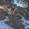
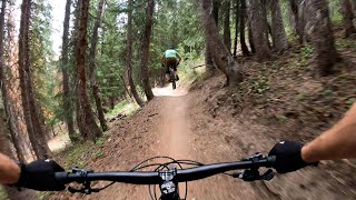
Great up and down. Amazing views at top, great connection to the crest. Also provides cool transitions between aspens, alpine meadows and pine trees. The waterbars at the top give you a bunch of little jumps through some tight pine trees, making this top section a favorite descent.
This is a very popular climbing trail to get to the Crest from PC, so watch for riders coming up if you are descending. If looking for an alternate climbing route to the crest, see the Blazing Saddle connector via Comstock or Keystone.
Local Trail Association
-

-
Please consider joining or donating to the local trail association to supportdonate to earn trail karma!
trail development & maintenance.
Traditionally Indigenous Territory
More Stats for Pinecone Ridge bike trail trail
-
Altitude change1,424 ft
-
Altitude min8,395 ft
-
Altitude max9,821 ft
-
Altitude start8,397 ft
-
Altitude end9,821 ft
-
Grade6.906%
-
Grade max-38.62%
-
Grade min105.88%
-
Distance climb3 miles
-
Distance down2,218 ft
-
Avg time00:56:32
-
Avg reverse time00:26:29
- view trail stats
close
Trail Conditions
- Unknown
- Snow Groomed
- Snow Packed
- Snow Covered
- Snow Cover Inadequate
- Freeze/thaw Cycle
- Icy
- Prevalent Mud
- Wet
- Variable
- Ideal
- Dry
- Very Dry
Trail Flow (Ridden Direction)
Trailforks scans users ridelogs to determine the most popular direction each trail is ridden. A good flowing trail network will have most trails flowing in a single direction according to their intension.
The colour categories are based on what percentage of riders are riding a trail in its intended direction.
The colour categories are based on what percentage of riders are riding a trail in its intended direction.
- > 96%
- > 90%
- > 80%
- > 70%
- > 50%
- < 50%
- bi-directional trail
- no data
Trail Last Ridden
Trailforks scans ridelogs to determine the last time a trail was ridden.
- < 2 days
- < 1 week
- < 2 weeks
- < 1 month
- < 6 months
- > 6 months
Trail Ridden Direction
The intended direction a trail should be ridden.
- Downhill Only
- Downhill Primary
- Both Directions
- Uphill Primary
- Uphill Only
- One Direction
Contribute Details
Colors indicate trail is missing specified detail.
- Description
- Photos
- Description & Photos
- Videos
Trail Popularity ?
Trailforks scans ridelogs to determine which trails are ridden the most in the last 9 months.
Trails are compared with nearby trails in the same city region with a possible 25 colour shades.
Think of this as a heatmap, more rides = more kinetic energy = warmer colors.
- most popular
- popular
- less popular
- not popular
ATV/ORV/OHV Filter
Max Vehicle Width
inches
Radar Time
x
Activity Recordings
Trailforks users anonymized public ridelogs from the past 6 months.
- mountain biking recent
- mountain biking (>6 month)
- hiking (1 year)
- moto (1 year)
Activity Recordings
Trailforks users anonymized public skilogs from the past 12 months.
- Downhill Ski
- Backcountry Ski
- Nordic Ski
Jump Magnitude Heatmap
Heatmap of where riders jump on trails. Zoom in to see individual jumps, click circles to view jump details.
Trails Deemphasized
Trails are shown in grey.
Only show trails with NO bikes.
Save the current map location and zoom level as your default home location whenever this page is loaded.
Save
Directions to pinecone-ridge trailhead
(40.647080, -111.538210)
update trails status or condition
Pinecone Ridge Trail Reports
view all reports »
Recent Ridelog Activity on Trail
Past Week
- 94 rides
- 23 miles avg distance
6 Months
- 282 rides
- 22 miles avg distance
All
- 6,251 rides
Photos
more »
Trail Lists
-
PC - Zone #9
71 trails
-
 Adaptive Trails- Park City8 trails
Routes with this trail
more »
Trail Products
-
+ 0
 slambiase
Made it to a little over 9100ft before hitting some mud and snow Sunday
[Reply]
mranzin
(Aug 30, 2021 at 18:18)
I usually keep my timber bell on during the climb to alert the shuttle bros before they skid into me. It’s good both ways, but if you bash into someone on your descent, that’s on you, because it’s super popular both ways. Also, it’s nowhere near as sketchy as the also bidirectional Spiro.
[Reply]
Henke14
 (Jul 13, 2021 at 19:53)
So torn here. Beautiful up and down. However, this is a collision accident waiting to happen. Almost had to bail off my bike on the way up as a DH rider was going too fast to stop around a blind curve. Given the proximity of Armstrong and the crest access, something badly needs to be done here. Designated up days? Alternating days? Another up only trail to connect from Armstrong? Again, can't recommend because it was dangerous beyond what is necessary but it was a beautiful trail for sure. Sad.
[Reply]
Gravityclown
(May 31, 2020 at 21:21)
Clear up to 8800 feet then fallen trees mud and eventually some snow pack. Turned around at 8900 feet.
[Reply]
sgoldfield
(Aug 6, 2019 at 12:04)
It's only a sketchy climb if you are riding out of control downhill. Armstrong to Pinecone is a fantastic beautiful and shaded way to climb to the top of the crest. It is also one of my personal favorite downhills, but it is a two-way trail and should be ridden as such. There are plenty of places on it with good sight lines that you can open it up as long as you are careful when it gets tighter lower down. Everyone can safely enjoy this trail both up and down.
[Reply]
 hi-dr-nick
For god sakes people only climb this if it’s early season and other routes to the crest aren’t open yet. It’s such a high speed descent that it’s really sketch to climb.
[Reply]
thesquid
(Sep 3, 2017 at 0:31)
Awesome high elevation climb and descent. One of the best in Northern Utah.
[Reply]
Fast44
(Jul 19, 2017 at 18:50)
Fantastic climb to Wasatch Crest. Rides beautifully in either direction. Mostly climbs in stands of aspen trees, then higher up, pines. Nicely shaded and protects from wind. Comes out right at the top of Puke Hill, which is the brief, painful sun exposed fireroad access traditionally used by Wasatch Crest shuttlers riding north from Guardsmans Pass. From town via Armstrongs/ Pinecone ridge is just over 2900ft climb. Felt like less.
[Reply]
Videos
more »

12:37 |
8 |
Jul 4, 2022 , Park City
3:02 |
219 |
Jul 13, 2021 , Park City
5:52 |
128 |
Aug 7, 2020 , Park City
11:38 |
46 |
Aug 7, 2020 , Park City
Nearby Trails
- H.a.m. 2,772 ft
- Mid Mountain 2,907 ft
- Claim Jumper 3,684 ft
- Dawns Trail 4,573 ft
- Motherlode Lift 4,816 ft
Park City Mountain Resort
- embed Pinecone Ridge trail on your website
- By todd Trailforks & contributors
- #11636 - 12,568 views
- subscribe
- login to download gpx or kml files.