Heaven's Bench Details
-
Activities
- Mountain Bike
- Hike
- Trail Running
- Snowshoe
-
Riding AreaKingdom Trails
East Burke, Vermont -
Difficulty Rating
-
Trail TypeMachine Groomed
-
Snow GroomingGroomed Smooth
-
Bike TypeAM, XC, Fat, Adaptive MTB
-
DirectionBoth DirectionsPopular direction shown
-
Climb DifficultyBlue
-
Physical RatingModerate
-
Trail VisibilityAlways easy to follow
-
eBike Allowed
-
Global Ranking
-
Local Popularity90 in Mountain Biking [+]
- 80 in Trail Running
- 100 in Hiking
- 100 in Snowshoeing
-
Land ManagerKingdom Trail Association
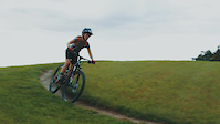
The Heaven's Bench lookout point is one of the most photographed scenic location in the entire Kingdom. The trail is a relatively easy trail suitable for all levels of riders. It has no significant obstacles and the ride surface is generally smooth and firm although the climb section traverses a grassy area. The climb from the Wildflower in up to the lookout point is a fairly long gentle climb.
Access Info
From the Wildflower Inn take Bill Magill up the hill and turn right onto the open field trail up the hill.
Disclaimer
The VAST is a primary use snowmobile trail. Fat bikers must yield to snowmobile traffic. Please respect the trail closure signs. No Fat Bikes to go beyond the point where signs are posted.
Local Trail Association
-

-

-
Please consider joining or donating to the local trail association to supportdonate to earn trail karma!
trail development & maintenance.
Traditionally Indigenous Territory
More Stats for Heaven's Bench bike trail trail
-
Altitude change8 ft
-
Altitude min1,126 ft
-
Altitude max1,134 ft
-
Altitude start1,126 ft
-
Altitude end1,135 ft
-
Grade0.9%
-
Grade min4.9%
-
Distance climb404 ft
-
Distance flat463 ft
-
Avg time00:07:23
-
Avg reverse time00:09:14
- view trail stats
- Unknown
- Snow Groomed
- Snow Packed
- Snow Covered
- Snow Cover Inadequate
- Freeze/thaw Cycle
- Icy
- Prevalent Mud
- Wet
- Variable
- Ideal
- Dry
- Very Dry
The colour categories are based on what percentage of riders are riding a trail in its intended direction.
- > 96%
- > 90%
- > 80%
- > 70%
- > 50%
- < 50%
- bi-directional trail
- no data
- < 2 days
- < 1 week
- < 2 weeks
- < 1 month
- < 6 months
- > 6 months
- Downhill Only
- Downhill Primary
- Both Directions
- Uphill Primary
- Uphill Only
- One Direction
- Description
- Photos
- Description & Photos
- Videos
- most popular
- popular
- less popular
- not popular
- mountain biking recent
- mountain biking (>6 month)
- hiking (1 year)
- moto (1 year)
- Downhill Ski
- Backcountry Ski
- Nordic Ski
Save the current map location and zoom level as your default home location whenever this page is loaded.
SaveHeaven's Bench Trail Reports
Recent Ridelog Activity on Trail
Past Week
- 57 rides
- 13 miles avg distance
6 Months
- 529 rides
- 14 miles avg distance
All
- 5,638 rides

Photos
Trail Lists
Routes with this trail
Videos
Nearby Trails
- Vast Snowmobile Trail 1,017 ft
- Nordic Center Access Road & Parking 1,017 ft
- Bill Magill 1,017 ft
- Fox Run 1,191 ft
- Ele 1156 1,391 ft
- embed Heaven's Bench trail on your website
- By WillieJacobsz
 TRAILFORKS NEMBA & contributors
 - #4164 - 4,721 views
- subscribe
- login to download gpx or kml files.