1.6 miles
Distance
-1,221 ft
Descent
00:12:32
Avg time
Supporters, Builders, Maintainers & Land Managers of Base Nato Trail

Finale Outdoor RegionLand Manager
Base Nato Details
-
Activities
- Mountain Bike
- E-Bike
-
Riding AreaFinale Outdoor Region
Finale Ligure -
Ref Number#92
-
Difficulty Rating
-
Voted DifficultyBlue (1 vote)
-
Trail TypeDoubletrack
-
Bike TypeAM, XC, Gravel, Adaptive MTB
-
DirectionDownhill OnlyPopular direction shown
-
Climb DifficultyGreen
-
Physical RatingModerate
-
Trail VisibilityAlways easy to follow
-
SeasonAll-year round
-
Dogs AllowedYes
-
eBike AllowedYes up to Class 1
-
Global Ranking
-
Local Popularity100 in Mountain Biking [+]
- 100 in E-Biking
-
Land ManagerFinale Outdoor Region
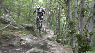
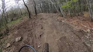
One of the first trails built in the Nato Base area. The longest trail of the 4 that roll down straight from the Base itself, and one of the most fun. Fast lines, banks, tiny jumps and a lot of flow, definitely a must-ride of the area. The cool scenery of the Nato Base is a great introduction to the very fun trails that lay ahead.
source: ...
Access Info
Nato Base Area is reachable from the E80 highway accessing Orco Feglino, then drive north on the SP23 until the windmills under the Base.
Disclaimer
Slow down at the gravel road crossings. Given its nature, the trail can change after weather happenings and season changes. Always pay attention.
Local Trail Association
-
-
Please consider joining or donating to the local trail association to supportdonate to earn trail karma!
trail development & maintenance.
More Stats for Base Nato mountain bike trail trail
-
Altitude change-1,221 ft
-
Altitude min2,105 ft
-
Altitude max3,326 ft
-
Altitude start3,326 ft
-
Altitude end2,106 ft
-
Grade-14.5%
-
Grade max-47.6%
-
Grade min-0.3%
-
Distance down2 miles
-
Distance flat98 ft
-
Avg time00:12:32
-
Avg reverse time00:28:05
- view trail stats
close
Trail Conditions
- Unknown
- Snow Groomed
- Snow Packed
- Snow Covered
- Snow Cover Inadequate
- Freeze/thaw Cycle
- Icy
- Prevalent Mud
- Wet
- Variable
- Ideal
- Dry
- Very Dry
Trail Flow (Ridden Direction)
Trailforks scans users ridelogs to determine the most popular direction each trail is ridden. A good flowing trail network will have most trails flowing in a single direction according to their intension.
The colour categories are based on what percentage of riders are riding a trail in its intended direction.
The colour categories are based on what percentage of riders are riding a trail in its intended direction.
- > 96%
- > 90%
- > 80%
- > 70%
- > 50%
- < 50%
- bi-directional trail
- no data
Trail Last Ridden
Trailforks scans ridelogs to determine the last time a trail was ridden.
- < 2 days
- < 1 week
- < 2 weeks
- < 1 month
- < 6 months
- > 6 months
Trail Ridden Direction
The intended direction a trail should be ridden.
- Downhill Only
- Downhill Primary
- Both Directions
- Uphill Primary
- Uphill Only
- One Direction
Contribute Details
Colors indicate trail is missing specified detail.
- Description
- Photos
- Description & Photos
- Videos
Trail Popularity ?
Trailforks scans ridelogs to determine which trails are ridden the most in the last 9 months.
Trails are compared with nearby trails in the same city region with a possible 25 colour shades.
Think of this as a heatmap, more rides = more kinetic energy = warmer colors.
- most popular
- popular
- less popular
- not popular
ATV/ORV/OHV Filter
Max Vehicle Width
inches
Radar Time
x
Activity Recordings
Trailforks users anonymized public ridelogs from the past 6 months.
- mountain biking recent
- mountain biking (>6 month)
- hiking (1 year)
- moto (1 year)
Activity Recordings
Trailforks users anonymized public skilogs from the past 12 months.
- Downhill Ski
- Backcountry Ski
- Nordic Ski
Jump Magnitude Heatmap
Heatmap of where riders jump on trails. Zoom in to see individual jumps, click circles to view jump details.
Trails Deemphasized
Trails are shown in grey.
Only show trails with NO bikes.
Save the current map location and zoom level as your default home location whenever this page is loaded.
Save
Directions to base-nato trailhead
(44.248560, 8.278950)
update trails status or condition
Base Nato Trail Reports
view all reports »
Recent Ridelog Activity on Trail
Past Week
- 12 rides
- 25 miles avg distance
6 Months
- 687 rides
- 28 miles avg distance
All
- 3,953 rides
Routes with this trail
more »

Videos
more »
youtuber
![Finale 2022, Base Nato #92]()

8:53 |
207 |
Feb 9, 2022 , Finale Ligure

7:37 |
52 |
May 16, 2022 , Finale Ligure
1:04 |
755 |
Jun 11, 2020 , Finale Ligure
3:58 |
487 |
May 20, 2020 , Finale Ligure
Nearby Trails
- Crestino Pt. 1 0 ft
- 115 361 ft
- Madre Natura 361 ft
- H Trail 1,470 ft
- Variante Per La Base Nato 5,240 ft
Finale Outdoor Region
- embed Base Nato trail on your website
- By cheorch
 & contributors
 - #46086 - 22,448 views
- subscribe
- login to download gpx or kml files.