2.9 miles
Distance
198 ft
Climb
-261 ft
Descent
00:36:31
Avg time
Supporters, Builders, Maintainers & Land Managers of Llama Trail
USFSLand Manager
Llama Details
-
Activities
- Mountain Bike
- Hike
- Trail Running
- Horse
-
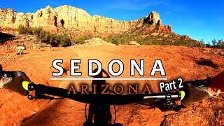
Riding AreaVillage of Oak Creek
Sedona, Arizona -
Difficulty Rating
-
Voted DifficultyBlue (2 votes)
-
Trail TypeSingletrack
-
Bike Type
-
DirectionBoth Directions
-
Dogs AllowedYes
-
eBike Allowed
-
Global Ranking
-
Local Popularity90 in Mountain Biking [+]
- 55 in Trail Running
- 60 in Hiking
- 5 in Horseback
Beginner 10%, intermediate 70% and advanced 20%, 2.8 mile MTB trail which is a bi-directional singletrack that is a twisty up and down trail with several technical uphill sections that will test a lesser skilled rider. The trail tread is mostly packed dirt mixed with rocks and a number of slickrock sections. There is no preferred direction but it is somewhat easier north to south direction. The trail is a great connector for several fun loops.
Adaptive Bike Info
aMTB 2 Rating: Obstacles exist. You may or may not be able to ride this solo. Support rider recommended.
Very technical, but actually do-able solo depending on your ability. Best clockwise.
Local Trail Association
-

-

-

-

-
Please consider joining or donating to the local trail association to supportdonate to earn trail karma!
trail development & maintenance.
Traditionally Indigenous Territory
More Stats for Llama bike trail trail
-
Altitude change-62 ft
-
Altitude min4,318 ft
-
Altitude max4,445 ft
-
Altitude start4,386 ft
-
Altitude end4,324 ft
-
Grade-0.4%
-
Grade max-14%
-
Grade min16.4%
-
Distance climb4,482 ft
-
Distance down1 mile
-
Distance flat4,531 ft
-
Avg time00:36:31
-
Avg reverse time00:37:30
- view trail stats
close
Trail Conditions
- Unknown
- Snow Groomed
- Snow Packed
- Snow Covered
- Snow Cover Inadequate
- Freeze/thaw Cycle
- Icy
- Prevalent Mud
- Wet
- Variable
- Ideal
- Dry
- Very Dry
Trail Flow (Ridden Direction)
Trailforks scans users ridelogs to determine the most popular direction each trail is ridden. A good flowing trail network will have most trails flowing in a single direction according to their intension.
The colour categories are based on what percentage of riders are riding a trail in its intended direction.
The colour categories are based on what percentage of riders are riding a trail in its intended direction.
- > 96%
- > 90%
- > 80%
- > 70%
- > 50%
- < 50%
- bi-directional trail
- no data
Trail Last Ridden
Trailforks scans ridelogs to determine the last time a trail was ridden.
- < 2 days
- < 1 week
- < 2 weeks
- < 1 month
- < 6 months
- > 6 months
Trail Ridden Direction
The intended direction a trail should be ridden.
- Downhill Only
- Downhill Primary
- Both Directions
- Uphill Primary
- Uphill Only
- One Direction
Contribute Details
Colors indicate trail is missing specified detail.
- Description
- Photos
- Description & Photos
- Videos
Trail Popularity ?
Trailforks scans ridelogs to determine which trails are ridden the most in the last 9 months.
Trails are compared with nearby trails in the same city region with a possible 25 colour shades.
Think of this as a heatmap, more rides = more kinetic energy = warmer colors.
- most popular
- popular
- less popular
- not popular
ATV/ORV/OHV Filter
Max Vehicle Width
inches
Radar Time
x
Activity Recordings
Trailforks users anonymized public ridelogs from the past 6 months.
- mountain biking recent
- mountain biking (>6 month)
- hiking (1 year)
- moto (1 year)
Activity Recordings
Trailforks users anonymized public skilogs from the past 12 months.
- Downhill Ski
- Backcountry Ski
- Nordic Ski
Jump Magnitude Heatmap
Heatmap of where riders jump on trails. Zoom in to see individual jumps, click circles to view jump details.
Trails Deemphasized
Trails are shown in grey.
Only show trails with NO bikes.
Save the current map location and zoom level as your default home location whenever this page is loaded.
Save
Directions to llama trailhead
(34.805330, -111.761780)
update trails status or condition
Llama Trail Reports
view all reports »
Recent Ridelog Activity on Trail
Past Week
- 8 rides
- 13 miles avg distance
6 Months
- 542 rides
- 14 miles avg distance
All
- 3,780 rides
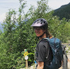
Photos
more »
Routes with this trail
more »
-
+ 0
AJLawson62
 (Nov 3, 2021 at 8:55)
funnest techy
[Reply]
ArizonaAdrenaline
(May 21, 2020 at 15:14)
I personally loved this trail, definitely on the upper end of challenging. The rock slabs are really fun and while technical, the rock features are awesome too.
[Reply]
 twowheeledwanderer
(Nov 16, 2019 at 7:48)
twowheeledwanderer
(Nov 16, 2019 at 7:48)
Llama is my favorite easy/intermediate trail in Sedona. Most of it is fast pedal, but there are a couple of sections that may take you by surprise. It's best ridden counterclockwise (green to red). I wrote up a blog post about the 8 best trails in Sedona (in my opinion) and Llama is one of them twowheeledwanderer.com/posts/my-eight-favorite-mountain-bike-trails-in-sedona-arizona
[Reply]
 ajriding
(May 1, 2019 at 9:57)
ajriding
(May 1, 2019 at 9:57)
Fun lil trail with classic rock features mixed w red dirt trails
[Reply]
otbspecialist
(Jan 24, 2019 at 15:13)
Fun trail. More challenging than other blue trails in bell rock area.
[Reply]
Vaurobghan
(Apr 8, 2018 at 7:08)
One of my favorite trails. Better riding towards Little Horse From Bell Rock
[Reply]

Videos
more »


Nearby Trails
- Baby Bell Option 1,198 ft
- Baby Bell Overlook 1,670 ft
- Phone 1,969 ft
- Bell Rock Acc 2,274 ft
- Templeton 2,589 ft
Village of Oak Creek
- embed Llama trail on your website
- By todd Trailforks & contributors
- #14546 - 8,477 views
- subscribe
- login to download gpx or kml files.