close
Trail Conditions
- Unknown
- Snow Groomed
- Snow Packed
- Snow Covered
- Snow Cover Inadequate
- Freeze/thaw Cycle
- Icy
- Prevalent Mud
- Wet
- Variable
- Ideal
- Dry
- Very Dry
Trail Flow (Ridden Direction)
Trailforks scans users ridelogs to determine the most popular direction each trail is ridden. A good flowing trail network will have most trails flowing in a single direction according to their intension.
The colour categories are based on what percentage of riders are riding a trail in its intended direction.
The colour categories are based on what percentage of riders are riding a trail in its intended direction.
- > 96%
- > 90%
- > 80%
- > 70%
- > 50%
- < 50%
- bi-directional trail
- no data
Trail Last Ridden
Trailforks scans ridelogs to determine the last time a trail was ridden.
- < 2 days
- < 1 week
- < 2 weeks
- < 1 month
- < 6 months
- > 6 months
Trail Ridden Direction
The intended direction a trail should be ridden.
- Downhill Only
- Downhill Primary
- Both Directions
- Uphill Primary
- Uphill Only
- One Direction
Contribute Details
Colors indicate trail is missing specified detail.
- Description
- Photos
- Description & Photos
- Videos
Trail Popularity ?
Trailforks scans ridelogs to determine which trails are ridden the most in the last 9 months.
Trails are compared with nearby trails in the same city region with a possible 25 colour shades.
Think of this as a heatmap, more rides = more kinetic energy = warmer colors.
- most popular
- popular
- less popular
- not popular
ATV/ORV/OHV Filter
Max Vehicle Width
inches
Radar Time
x
Activity Recordings
Trailforks users anonymized public ridelogs from the past 6 months.
- mountain biking recent
- mountain biking (>6 month)
- hiking (1 year)
- moto (1 year)
Activity Recordings
Trailforks users anonymized public skilogs from the past 12 months.
- Downhill Ski
- Backcountry Ski
- Nordic Ski
Jump Magnitude Heatmap
Heatmap of where riders jump on trails. Zoom in to see individual jumps, click circles to view jump details.
Trails Deemphasized
Trails are shown in grey.
Only show trails with NO bikes.
Save the current map location and zoom level as your default home location whenever this page is loaded.
Save
No description for Village of Oak Creek has been added yet!
Login or register to submit one.
 google parking directions
google parking directions Activities Click to view
- Mountain Bike
38 trails
- Hike
46 trails
- Trail Running
46 trails
- Horse
23 trails
Region Details
- 1
- 3
- 19
- 14
- 1
Region Status
Open as of Jan 25, 2022Stats
- Avg Trail Rating
- Trails (view details)
- 46
- Trails Mountain Bike
- 38
- Trails Hike
- 46
- Trails Trail Running
- 46
- Trails Horse
- 23
- Total Distance
- 49 miles
- Total Descent
- 6,317 ft
- Total Vertical
- 988 ft
- Highest Trailhead
- 4,800 ft
- Reports
- 1,057
- Photos
- 765
- Ridden Counter
- 33,878
 Articles

Arizona's 5 Most Popular Trail Networks According to Trailforks Data
Oct 19, 2021 from pinkbike.com
The American Southwest is chock full of bucket list locales, and perhaps no single southwestern state is home to more of them than Arizona.
Popular Village of Oak Creek Mountain Biking Trails
Village of Oak Creek Mountain Bike Routes
| title | rating | distance |
|---|---|---|
| Sedona: Hiline, Baldwin, Templeton, Hermit | 9 miles | |
| Hiline Loop + Slim Shady bonus | 10 miles | |
| Roam Fest Sedona - VOC 3 - Llama | 7 miles | |
| Hiline from Absolute Bikes | 11 miles | |
| Roam Fest Sedona - VOC 1 - Big Park Loop | 3 miles | |
| Roam Fest Sedona - VOC 4 - Slim Shady (Short) | 5 miles | |
| Slim Shady Etc | 11 miles | |
| Trail One List - Hiline | 11 miles | |
| Roam Fest Sedona - VOC 5 - Slim Shady (Long) | 11 miles | |
| Little Rock Rabbit Ears Counterclockwise | 4 miles |
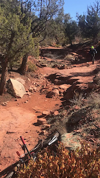
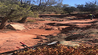
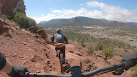
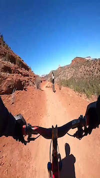
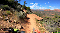
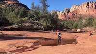
Photos of Village of Oak Creek Mountain Bike
trail: Llama
653 |
Jan 18, 2018 @ 8:03am
Jan 18, 2018
trail: Hiline
473 |
Jan 1, 2018 @ 8:59pm
Jan 1, 2018
trail: Slim Shady
148 |
Dec 28, 2017 @ 4:09pm
Dec 28, 2017
trail: Slim Shady
130 |
Dec 28, 2017 @ 4:09pm
Dec 28, 2017
trail: Slim Shady
687 |
Dec 27, 2017 @ 10:21pm
Dec 27, 2017
trail: Hiline
609 |
May 3, 2017 @ 11:49am
May 3, 2017
trail: Hiline
1,075 |
Apr 13, 2017 @ 10:33am
Apr 13, 2017
trail: Llama
1,009 |
Mar 20, 2016 @ 9:33pm
Mar 20, 2016Videos of Village of Oak Creek Mountain Bike

trail: Bell Rock Pathway
16 |
Apr 11, 2022

trail: Hiline
14 |
Jan 20, 2022
trail: Slim Shady
95 |
Jan 2, 2022
trail: Slim Shady
|
Jan 2, 2022
trail: Hiline
196 |
Mar 16, 2021
trail: Slim Shady
116 |
Mar 15, 2021
trail: Hiline
0:12 |
540 |
Jun 29, 2020
trail: Courthouse Butte Loop
0:07 |
275 |
Mar 7, 2020
Recent Trail Reports
| status | trail | date | condition | info | user |
|---|---|---|---|---|---|
| Hiline | May 18, 2022 @ 1:52pm May 18, 2022 | Dry | kkowalchik | ||
| Baldwin Alt | May 15, 2022 @ 6:28am May 15, 2022 | Dry | asspadtycoon | ||
| Ht Trail | May 15, 2022 @ 6:28am May 15, 2022 | Dry | asspadtycoon | ||
| Phone | May 15, 2022 @ 6:28am May 15, 2022 | Dry | asspadtycoon | ||
| Access Road | May 15, 2022 @ 6:28am May 15, 2022 | Dry | asspadtycoon | ||
| Big Park Loop | May 6, 2022 @ 7:11am May 6, 2022 | Dry | gcm1221 | ||
| Baby Bell Overlook | May 4, 2022 @ 9:17am May 4, 2022 | Dry | asspadtycoon | ||
| Bell Rock Pathway | May 4, 2022 @ 9:17am May 4, 2022 | Dry | asspadtycoon | ||
| Bell Rock Singletrack Bypass | May 4, 2022 @ 9:17am May 4, 2022 | Dry | asspadtycoon | ||
| Kel Fox | Apr 29, 2022 @ 12:06pm Apr 29, 2022 | Very Dry | prcek63 |
Activity Feed
| username | action | type | title | date | |
|---|---|---|---|---|---|
 | javmant | wishlist | route | Trail One List - Hiline and 1 more | Jul 4, 2022 @ 10:24pm 1 day |
| Hyenamtb | ridden | poi | Rock Drop | Jul 4, 2022 @ 6:29pm 1 day |
 | Shafto | vote | trail | Hiline | Jul 4, 2022 @ 5:52pm 1 day |
| javmant | wishlist | route | Trail One List - Hiline | Jul 4, 2022 @ 1:24pm 2 days |
| Luisfierro1 | wishlist | route | Roam Fest Sedona - VOC 1 - Big Park Loop | Jul 4, 2022 @ 12:10pm 2 days |
Recent Comments
| username | type | title | comment | date | |
|---|---|---|---|---|---|
 | report | Whose sign was it? | Jun 15, 2022 @ 11:22pm Jun 15, 2022 | ||
 | report | Yes actually. There was a sign up stating... | Jun 14, 2022 @ 6:23pm Jun 14, 2022 | ||
| report | "Now one-way only for bikes. Must ride section... | Jun 14, 2022 @ 4:12pm Jun 14, 2022 | ||
| trail | If this is your exit route, be careful the... | May 27, 2022 @ 7:18pm May 27, 2022 | ||
| trail | If you're on the fence about riding this... | May 9, 2022 @ 4:30pm May 9, 2022 |
Nearby Areas
| name | distance | ||||
|---|---|---|---|---|---|
| Broken Arrow | 1 | 6 | 7 | 2 | 2.4 km |
| Turkey Creek | 5 | 2 | 3.2 km | ||
| Red Rock State Park | 1 | 3.7 km | |||
| Carroll Canyon | 1 | 10 | 12 | 4 km | |
| Adobe Jack | 4 | 13 | 13 | 1 | 5.5 km |
Local Badges
-

Completionist1 awarded
Pinkbike Articles
Oct 19, 2021
 Arizona's 5 Most Popular Trail Networks According to Trailforks Data
The American Southwest is chock full of bucket list locales, and perhaps no single southwestern state is home to more of them than Arizona.
Mar 17, 2020
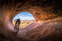 Photo Story: Stunning Images in 'Unsettling - Going Full Nomad'
A year of being houseless and chasing happiness.
Jan 2, 2017
 Chasing Epic Season Wrap, In Pictures
Chasing Epic Mountain Bike Adventures look back on their first year and some of the amazing places they got to ride in 2016.
Activity Type Stats
| activitytype | trails | distance | descent | descent distance | total vertical | rating | global rank | state rank | photos | reports | routes | ridelogs |
|---|---|---|---|---|---|---|---|---|---|---|---|---|
| Mountain Bike | 38 | 43 miles | 5,866 ft | 19 miles | 912 ft | #49 | #21 | 737 | 1,050 | 33 | 13,015 | |
| Hike | 46 | 49 miles | 6,319 ft | 21 miles | 988 ft | #30 | #16 | 34 | 1,052 | 9 | 957 | |
| Trail Running | 46 | 49 miles | 6,319 ft | 21 miles | 988 ft | #29 | #15 | 1,052 | 5 | 421 | ||
| Horse | 23 | 35 miles | 3,570 ft | 14 miles | 912 ft | #5 | #4 | 3 | 429 | 2 | 10 |
- By markholloway
 Trailforks & contributors
 - Admins: SRRTF, MollyJoyce
- #35659 - 7,940 views
- village of oak creek activity log | embed map of Village of Oak Creek mountain bike trails | village of oak creek mountain biking points of interest
Downloading of trail gps tracks in kml & gpx formats is enabled for Village of Oak Creek.
You must login to download files.