close
Trail Conditions
- Unknown
- Snow Groomed
- Snow Packed
- Snow Covered
- Snow Cover Inadequate
- Freeze/thaw Cycle
- Icy
- Prevalent Mud
- Wet
- Variable
- Ideal
- Dry
- Very Dry
Trail Flow (Ridden Direction)
Trailforks scans users ridelogs to determine the most popular direction each trail is ridden. A good flowing trail network will have most trails flowing in a single direction according to their intension.
The colour categories are based on what percentage of riders are riding a trail in its intended direction.
The colour categories are based on what percentage of riders are riding a trail in its intended direction.
- > 96%
- > 90%
- > 80%
- > 70%
- > 50%
- < 50%
- bi-directional trail
- no data
Trail Last Ridden
Trailforks scans ridelogs to determine the last time a trail was ridden.
- < 2 days
- < 1 week
- < 2 weeks
- < 1 month
- < 6 months
- > 6 months
Trail Ridden Direction
The intended direction a trail should be ridden.
- Downhill Only
- Downhill Primary
- Both Directions
- Uphill Primary
- Uphill Only
- One Direction
Contribute Details
Colors indicate trail is missing specified detail.
- Description
- Photos
- Description & Photos
- Videos
Trail Popularity ?
Trailforks scans ridelogs to determine which trails are ridden the most in the last 9 months.
Trails are compared with nearby trails in the same city region with a possible 25 colour shades.
Think of this as a heatmap, more rides = more kinetic energy = warmer colors.
- most popular
- popular
- less popular
- not popular
ATV/ORV/OHV Filter
Max Vehicle Width
inches
Radar Time
x
Activity Recordings
Trailforks users anonymized public ridelogs from the past 6 months.
- mountain biking recent
- mountain biking (>6 month)
- hiking (1 year)
- moto (1 year)
Activity Recordings
Trailforks users anonymized public skilogs from the past 12 months.
- Downhill Ski
- Backcountry Ski
- Nordic Ski
Jump Magnitude Heatmap
Heatmap of where riders jump on trails. Zoom in to see individual jumps, click circles to view jump details.
Trails Deemphasized
Trails are shown in grey.
Only show trails with NO bikes.
Save the current map location and zoom level as your default home location whenever this page is loaded.
Save
No description for Utah Olympic Park has been added yet!
Login or register to submit one.
 google parking directions
AKA: UOP
google parking directions Activities Click to view
- Mountain Bike
29 trails
- Hike
29 trails
- Trail Running
28 trails
Region Details
- 1
- 1
- 7
- 15
- 5
Region Status
Caution as of Jun 11, 2022Stats
- Avg Trail Rating
- Trails (view details)
- 37
- Trails Mountain Bike
- 29
- Trails Hike
- 29
- Trails Trail Running
- 28
- Trails Horse
- 1
- Trails Snowshoe
- 5
- Trails Nordic Ski
- 3
- Total Distance
- 33 miles
- Total Descent
- 7,340 ft
- Total Vertical
- 1,874 ft
- Highest Trailhead
- 8,275 ft
- Reports
- 660
- Photos
- 207
- Ridden Counter
- 16,220
Popular Utah Olympic Park Mountain Biking Trails
Utah Olympic Park Mountain Bike Routes
| title | rating | distance |
|---|---|---|
| Flying Glenwild Dog Loop | 16 miles | |
| Flying Dog Loop From GW Trailhead | 16 miles | |
| Flying Dog Loop from Glenwild | 16 miles | |
| Olympic BushyRob | 14 miles | |
| Utah Olympic Park Lower Route | 6 miles | |
| Iron Bill circuit Moose Puddle | 12 miles | |
| VHS - JD Loop 6.17.21 | 6 miles | |
| Canyons to Millcreek Rattlesnake Shuttle | 21 miles | |
| Rambush+ | 15 miles | |
| VHS - Red/Gold 6.17.21 | 19 miles |
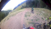
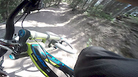
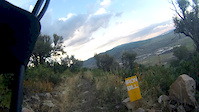
Photos of Utah Olympic Park Mountain Bike
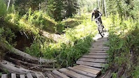
trail: Moose Puddle
22 |
Jun 11, 2022 @ 5:16pm
Jun 11, 2022
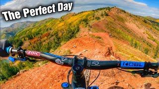
trail: Olympic
7 |
Aug 29, 2021 @ 5:09pm
Aug 29, 2021
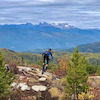
trail: Olympic
17 |
Aug 6, 2021 @ 8:32am
Aug 6, 2021
trail: Olympic
11 |
Aug 6, 2021 @ 8:32am
Aug 6, 2021
trail: Olympic
8 |
Aug 6, 2021 @ 8:32am
Aug 6, 2021
trail: Iron Bill
180 |
Sep 8, 2018 @ 2:46pm
Sep 8, 2018
trail: Yeti's
373 |
Oct 17, 2015 @ 4:53pm
Oct 17, 2015
trail: Yeti's
517 |
Oct 17, 2015 @ 4:53pm
Oct 17, 2015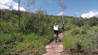


Current Trail Warnings
| status | trail | date | condition | user | info |
|---|---|---|---|---|---|
| Moose Puddle | Jul 4, 2022 @ 4:33pm 1 day | Dry | Sundance-47 | Still closed for construction. | |
| Yeti's | Jul 4, 2022 @ 4:32pm 1 day | Unknown | Sundance-47 | Per trail signage, closed for all of 2022. | |
| Olympic | Jun 24, 2022 @ 9:08am Jun 24, 2022 | Ideal | makita29 | Olympic is open, but only as an out and... |
Recent Trail Reports
| status | trail | date | condition | info | user |
|---|---|---|---|---|---|
| Insurgent | Jul 5, 2022 @ 6:57pm 9 hours | Dry | JeffGiles94 | ||
| BLT | Jul 4, 2022 @ 2:08pm 2 days | Ideal | Sundance-47 | ||
| BYOB | Jul 4, 2022 @ 2:08pm 2 days | Ideal | Sundance-47 | ||
| RTS | Jun 29, 2022 @ 8:11am Jun 29, 2022 | Ideal | Quintanaroo | ||
| Rocky Slab | Jun 29, 2022 @ 8:11am Jun 29, 2022 | Dry | Quintanaroo | ||
| Drop Kick | Jun 26, 2022 @ 9:41am Jun 26, 2022 | Ideal | jmac125 | ||
| Ricochet | Jun 19, 2022 @ 9:32am Jun 19, 2022 | Ideal | mkb5150 | ||
| RTS Lower | Jun 16, 2022 @ 4:20pm Jun 16, 2022 | Dry | edpankau | ||
| Iron Bill | Jun 13, 2022 @ 12:00am Jun 13, 2022 | Ideal | 1e9Yo7 | ||
| Holly's | Jun 11, 2022 @ 9:32pm Jun 11, 2022 | Ideal | falcon013 |
Activity Feed
| username | action | type | title | date | |
|---|---|---|---|---|---|
 | maddy03 | add | route | Rob's Trail | Jul 5, 2022 @ 11:04pm 5 hours |
 | JeffGiles94 | add | report | Insurgent and 1 more | Jul 5, 2022 @ 6:57pm 9 hours |
 | Cambamcook | wishlist | region | Utah Olympic Park | Jul 5, 2022 @ 6:33pm 9 hours |
| JeffGiles94 | comment | trail | Insurgent | Jul 5, 2022 @ 1:56pm 14 hours |
| Mbrennan22 | wishlist | route | Flying Glenwild Dog Loop | Jul 5, 2022 @ 9:15am 19 hours |
Recent Comments
| username | type | title | comment | date | |
|---|---|---|---|---|---|
| trail | Absolute blast. Super blown out and raw. | Jul 5, 2022 @ 1:56pm 14 hours | ||
| trail | So good. Best descent in the area | Jul 2, 2022 @ 9:28pm Jul 2, 2022 | ||
| trail | Unmaintained. Should have a closed sign up | Jul 2, 2022 @ 8:11am Jul 2, 2022 | ||
| trail | As of June 22, 2022, trail is closed due to... | Jun 24, 2022 @ 12:39pm Jun 24, 2022 | ||
| trail | Jun 22, 2022 @ 7:19pm Jun 22, 2022 |
Nearby Areas
| name | distance | ||||
|---|---|---|---|---|---|
| Glenwild | 24 | 2 | 2.4 km | ||
| Trailside Park | 18 | 10 | 3 | 2.9 km | |
| Woodward Park City | 5 | 3 | 1 | 1 | 2.9 km |
| North Basin | 1 | 8 | 2 | 3.4 km | |
| Round Valley | 26 | 36 | 4 | 4.6 km |
Local Badges
-

Completionist2 awarded
Local Products
Activity Type Stats
| activitytype | trails | distance | descent | descent distance | total vertical | rating | global rank | state rank | photos | reports | routes | ridelogs |
|---|---|---|---|---|---|---|---|---|---|---|---|---|
| Mountain Bike | 29 | 26 miles | 6,302 ft | 17 miles | 1,873 ft | #292 | #135 | 202 | 660 | 29 | 5,074 | |
| Hike | 29 | 25 miles | 5,331 ft | 15 miles | 1,873 ft | #286 | #169 | 607 | 2 | 546 | ||
| Trail Running | 28 | 25 miles | 5,269 ft | 15 miles | 1,873 ft | #288 | #168 | 3 | 607 | 4 | 222 | |
| Horse | 1 | 4,462 ft | 312 ft | 4,357 ft | 312 ft | 194 | 1 | |||||
| Snowshoe | 5 | 3 miles | 915 ft | 2 miles | 1,066 ft | 1 | 3 | |||||
| Nordic Ski | 3 | 4 miles | 371 ft | 1 mile | 315 ft | 42 |
- By todd
 Trailforks & contributors
 - Admins: MTF, todd
- #4812 - 9,982 views
- utah olympic park activity log | embed map of Utah Olympic Park mountain bike trails | utah olympic park mountain biking points of interest
Downloading of trail gps tracks in kml & gpx formats is enabled for Utah Olympic Park.
You must login to download files.