3,373 ft
Distance
88 ft
Climb
-173 ft
Descent
00:06:23
Avg time
North Leaf Details
-
Activities
- Mountain Bike
- Hike
- Trail Running
- Horse
-
Riding AreaEl Corte de Madera Creek Open Space Preserve
Redwood City, California -
Difficulty Rating
-
Trail TypeSingletrack
-
Dogs AllowedYes
-
eBike Allowed
-
Global Ranking
-
Local Popularity85 in Mountain Biking [+]
- 5 in Trail Running
- 70 in Hiking
- 5 in Horseback
-
Land ManagerMidpeninsula Regional Open Space District
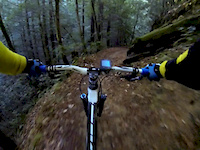
North Leaf is a narrow single track that has some technical sections. Right off the bat, there is a drop off of a root that could send an unwary beginner OTB. There are also some steep and rocky/rooty climbs that many may choose to walk. One section near the end of the trail squeezes you between a tree, some deep roots, and then dumps you out into a rocky drop. The end of the trail is the best - non-technical, very smooth, and fast
Local Trail Association
-

-
Please consider joining or donating to the local trail association to supportdonate to earn trail karma!
trail development & maintenance.
More Stats for North Leaf bike trail trail
-
Altitude change-86 ft
-
Altitude min1,752 ft
-
Altitude max1,864 ft
-
Altitude start1,838 ft
-
Altitude end1,752 ft
-
Grade-2.6%
-
Grade max-20.7%
-
Grade min30.2%
-
Distance climb817 ft
-
Distance down2,205 ft
-
Distance flat354 ft
-
Avg time00:06:23
-
Avg reverse time00:10:26
- view trail stats
close
Trail Conditions
- Unknown
- Snow Groomed
- Snow Packed
- Snow Covered
- Snow Cover Inadequate
- Freeze/thaw Cycle
- Icy
- Prevalent Mud
- Wet
- Variable
- Ideal
- Dry
- Very Dry
Trail Flow (Ridden Direction)
Trailforks scans users ridelogs to determine the most popular direction each trail is ridden. A good flowing trail network will have most trails flowing in a single direction according to their intension.
The colour categories are based on what percentage of riders are riding a trail in its intended direction.
The colour categories are based on what percentage of riders are riding a trail in its intended direction.
- > 96%
- > 90%
- > 80%
- > 70%
- > 50%
- < 50%
- bi-directional trail
- no data
Trail Last Ridden
Trailforks scans ridelogs to determine the last time a trail was ridden.
- < 2 days
- < 1 week
- < 2 weeks
- < 1 month
- < 6 months
- > 6 months
Trail Ridden Direction
The intended direction a trail should be ridden.
- Downhill Only
- Downhill Primary
- Both Directions
- Uphill Primary
- Uphill Only
- One Direction
Contribute Details
Colors indicate trail is missing specified detail.
- Description
- Photos
- Description & Photos
- Videos
Trail Popularity ?
Trailforks scans ridelogs to determine which trails are ridden the most in the last 9 months.
Trails are compared with nearby trails in the same city region with a possible 25 colour shades.
Think of this as a heatmap, more rides = more kinetic energy = warmer colors.
- most popular
- popular
- less popular
- not popular
ATV/ORV/OHV Filter
Max Vehicle Width
inches
Radar Time
x
Activity Recordings
Trailforks users anonymized public ridelogs from the past 6 months.
- mountain biking recent
- mountain biking (>6 month)
- hiking (1 year)
- moto (1 year)
Activity Recordings
Trailforks users anonymized public skilogs from the past 12 months.
- Downhill Ski
- Backcountry Ski
- Nordic Ski
Jump Magnitude Heatmap
Heatmap of where riders jump on trails. Zoom in to see individual jumps, click circles to view jump details.
Trails Deemphasized
Trails are shown in grey.
Only show trails with NO bikes.
Save the current map location and zoom level as your default home location whenever this page is loaded.
Save
Directions to north-leaf trailhead
(37.408870, -122.332030)
update trails status or condition
North Leaf Trail Reports
view all reports »
Recent Ridelog Activity on Trail
Past Week
- 9 rides
- 15 miles avg distance
6 Months
- 511 rides
- 13 miles avg distance
All
- 4,358 rides
Routes with this trail
more »
-
+ 1
 Kidklayko
(Mar 27, 2022 at 20:57)
Kidklayko
(Mar 27, 2022 at 20:57)
Great trail, rode it for the first time today, It's a little techy in some spots that could maybe make it a black, but for the most part it's a blue, Also this trail could use a haircut, it is slightly overgrown
[Reply]
mtbflauto
 (Jan 5, 2021 at 11:22)
The video for this trail looks like Methuselah, not North Leaf
[Reply]
 winkeyless
Midpen really should widen the narrowest part. It’s NOT safe to ride next to a cliff. Fun descent and best with a dropper
[Reply]
Videos
more »
3:25 |
588 |
Dec 8, 2013 , Redwood City
Nearby Trails
- Resolution 2,526 ft
- Tafoni (lower) 2,759 ft
- South Leaf 4,186 ft
- Methuselah 5,190 ft
- Methuselah 5,190 ft
El Corte de Madera Creek Open Space Preserve
- embed North Leaf trail on your website
- By brenthillier NSMBA TRAILFORKS & contributors
- #4911 - 2,366 views
- subscribe
- login to download gpx or kml files.