close
Trail Conditions
- Unknown
- Snow Groomed
- Snow Packed
- Snow Covered
- Snow Cover Inadequate
- Freeze/thaw Cycle
- Icy
- Prevalent Mud
- Wet
- Variable
- Ideal
- Dry
- Very Dry
Trail Flow (Ridden Direction)
Trailforks scans users ridelogs to determine the most popular direction each trail is ridden. A good flowing trail network will have most trails flowing in a single direction according to their intension.
The colour categories are based on what percentage of riders are riding a trail in its intended direction.
The colour categories are based on what percentage of riders are riding a trail in its intended direction.
- > 96%
- > 90%
- > 80%
- > 70%
- > 50%
- < 50%
- bi-directional trail
- no data
Trail Last Ridden
Trailforks scans ridelogs to determine the last time a trail was ridden.
- < 2 days
- < 1 week
- < 2 weeks
- < 1 month
- < 6 months
- > 6 months
Trail Ridden Direction
The intended direction a trail should be ridden.
- Downhill Only
- Downhill Primary
- Both Directions
- Uphill Primary
- Uphill Only
- One Direction
Contribute Details
Colors indicate trail is missing specified detail.
- Description
- Photos
- Description & Photos
- Videos
Trail Popularity ?
Trailforks scans ridelogs to determine which trails are ridden the most in the last 9 months.
Trails are compared with nearby trails in the same city region with a possible 25 colour shades.
Think of this as a heatmap, more rides = more kinetic energy = warmer colors.
- most popular
- popular
- less popular
- not popular
ATV/ORV/OHV Filter
Max Vehicle Width
inches
Radar Time
x
Activity Recordings
Trailforks users anonymized public ridelogs from the past 6 months.
- mountain biking recent
- mountain biking (>6 month)
- hiking (1 year)
- moto (1 year)
Activity Recordings
Trailforks users anonymized public skilogs from the past 12 months.
- Downhill Ski
- Backcountry Ski
- Nordic Ski
Jump Magnitude Heatmap
Heatmap of where riders jump on trails. Zoom in to see individual jumps, click circles to view jump details.
Trails Deemphasized
Trails are shown in grey.
Only show trails with NO bikes.
Save the current map location and zoom level as your default home location whenever this page is loaded.
SaveBeautiful multi-use trails right in the heart of Powell River. Frequented by joggers, walkers and dogs as well as cyclists.
Be courteous to all trail users
Be courteous to all trail users
Primary Trail Type: Cross-Country
Activities Click to view
- Mountain Bike
60 trails
- Hike
57 trails
- Trail Running
57 trails
Region Details
- 7
- 1
- 29
- 20
- 2
- 1
Region Status
Caution as of Oct 26, 2021Stats
- Avg Trail Rating
- Trails (view details)
- 60
- Trails Mountain Bike
- 60
- Trails E-Bike
- 13
- Trails Hike
- 57
- Trails Trail Running
- 57
- Trails Horse
- 47
- Trails Dirtbike/Moto
- 2
- Trails ATV/ORV/OHV
- 1
- Total Distance
- 24 miles
- Total Descent Distance
- 11 miles
- Total Descent
- 2,961 ft
- Total Vertical
- 628 ft
- Highest Trailhead
- 667 ft
- Reports
- 163
- Photos
- 37
- Ridden Counter
- 4,211
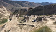
Popular Millennium Park Mountain Biking Trails
Millennium Park Mountain Bike Routes
| title | rating | distance |
|---|---|---|
| BC Bike Race 2018 (Day 3) Powell River race | 31 miles | |
| race | 31 miles |
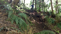
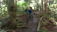
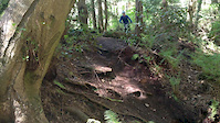
Photos of Millennium Park Mountain Bike
trail: CAMRA Ale Trail
16 |
Sep 16, 2021 @ 1:12pm
Sep 16, 2021
trail: Brooks Turf Road
15 |
Dec 7, 2020 @ 10:38am
Dec 7, 2020
trail: Whodunit
12 |
Aug 19, 2020 @ 5:51pm
Aug 19, 2020
trail: Whodunit
21 |
Aug 19, 2020 @ 5:50pm
Aug 19, 2020
trail: DUCK
51 |
Aug 16, 2020 @ 3:02pm
Aug 16, 2020
trail: Kingfisher Trail
45 |
Aug 8, 2020 @ 3:04pm
Aug 8, 2020
trail: McFall Creek Loop Trail
24 |
Aug 8, 2020 @ 3:04pm
Aug 8, 2020
trail: McFall Creek Loop Trail
21 |
Aug 8, 2020 @ 3:03pm
Aug 8, 2020Videos of Millennium Park Mountain Bike
trail: Valentine's Arrow (Pit)
3:14 |
258 |
Jun 27, 2017
trail: McFall Creek Trail
0:10 |
209 |
Apr 30, 2017
trail: McFall Creek Trail
0:11 |
145 |
Apr 30, 2017
trail: McFall Creek Trail
0:09 |
97 |
Apr 30, 2017
trail: Valentine's Arrow (Pit)
1:02 |
223 |
Nov 28, 2016

trail: Valentine's Arrow (Pit)
0:14 |
83 |
Feb 20, 2016

trail: Valentine's Arrow (Pit)
0:09 |
43 |
Feb 16, 2016

trail: Heart
0:55 |
58 |
Sep 8, 2015
Current Trail Warnings
| status | trail | date | condition | user | info |
|---|---|---|---|---|---|
| Haul Road | Jun 27, 2022 @ 11:06am Jun 27, 2022 | Dry | apinch | Effective tomorrow, Tues, June 28 to Sun,... | |
| Willingdon Campground Trail | Jun 23, 2022 @ 5:24pm Jun 23, 2022 | Dry | apinch | NOTICE: WILLINGDON BEACH TRAIL... | |
| Willingdon Beach Trail | Jun 23, 2022 @ 5:22pm Jun 23, 2022 | Dry | apinch | NOTICE: WILLINGDON BEACH TRAIL... |
Recent Trail Reports
| status | trail | date | condition | info | user |
|---|---|---|---|---|---|
| No More Books | Jun 22, 2022 @ 5:40pm Jun 22, 2022 | Ideal | bikebb PRCA | ||
| No More Pencils | Jun 22, 2022 @ 5:40pm Jun 22, 2022 | Ideal | bikebb PRCA | ||
| Over There | Jun 22, 2022 @ 5:40pm Jun 22, 2022 | Ideal | bikebb PRCA | ||
| Walley's Way | Jun 22, 2022 @ 5:40pm Jun 22, 2022 | Ideal | bikebb PRCA | ||
| McFall Creek Loop Trail | Jun 22, 2022 @ 5:40pm Jun 22, 2022 | Ideal | bikebb PRCA | ||
| Short and Curly | Jun 22, 2022 @ 5:40pm Jun 22, 2022 | Ideal | bikebb PRCA | ||
| Dale Trail | Apr 16, 2022 @ 10:20am Apr 16, 2022 | Ideal | apinch | ||
| McGuffie Trail | Apr 16, 2022 @ 10:18am Apr 16, 2022 | Variable | apinch | ||
| Oso Negro | Apr 16, 2022 @ 10:15am Apr 16, 2022 | Prevalent Mud | apinch | ||
| Yabadabadoo | Feb 25, 2022 @ 5:00pm Feb 25, 2022 | Variable | bikebb PRCA |
Activity Feed
| username | action | type | title | date | |
|---|---|---|---|---|---|
 | apinch | add | report | Haul Road | Jun 27, 2022 @ 11:06am Jun 27, 2022 |
| apinch | add | report | Willingdon Beach Trail and 1 more | Jun 23, 2022 @ 5:22pm Jun 23, 2022 |
 | bikebb | add | report | No More Books and 5 more | Jun 22, 2022 @ 8:25pm Jun 22, 2022 |
| bikebb | add | trail | Secret Trail | Jun 17, 2022 @ 2:46pm Jun 17, 2022 |
| bikebb | update | trail | McFall Creek Trail and 1 more | Jun 3, 2022 @ 2:16pm Jun 3, 2022 |
Recent Comments
| username | type | title | comment | date | |
|---|---|---|---|---|---|
| trail | Lower section is not uphill friendly. Lots of... | Aug 24, 2021 @ 11:44am Aug 24, 2021 | ||
| report | Damn. Thanks for the info. | Aug 23, 2021 @ 7:12pm Aug 23, 2021 | ||
| report | Nothing nefarious. | Aug 23, 2021 @ 5:11pm Aug 23, 2021 | ||
| report | Natural fall downs. Nothing nefarious | Aug 23, 2021 @ 5:10pm Aug 23, 2021 | ||
| report | You missed the turn at the top. You went left... | Aug 23, 2021 @ 5:10pm Aug 23, 2021 |
Nearby Areas
| name | distance | ||||
|---|---|---|---|---|---|
| Gallagher Hill | 1 | 8 | 1 | 1.4 km | |
| Penticton Street Maze | 16 | 31 | 3.8 km | ||
| West Lake Trails | 6 | 16 | 4 | 1 | 4.1 km |
| Duck Lake Trails | 20 | 43 | 5 | 4.1 km | |
| Mt. Mahony | 4 | 5 | 9 | 1 | 4.6 km |
Local Badges
-

Completionist0 awarded
Activity Type Stats
| activitytype | trails | distance | descent | descent distance | total vertical | rating | global rank | state rank | photos | reports | routes | ridelogs |
|---|---|---|---|---|---|---|---|---|---|---|---|---|
| Mountain Bike | 60 | 24 miles | 2,959 ft | 11 miles | 627 ft | #1,879 | #147 | 37 | 163 | 2 | 2,251 | |
| E-Bike | 13 | 5 miles | 535 ft | 2 miles | 420 ft | 125 | 13 | |||||
| Hike | 57 | 24 miles | 2,520 ft | 11 miles | 627 ft | #1,497 | #121 | 159 | 1 | 566 | ||
| Trail Running | 57 | 24 miles | 2,520 ft | 11 miles | 627 ft | #1,502 | #120 | 159 | 1 | 394 | ||
| Horse | 47 | 22 miles | 2,287 ft | 10 miles | 627 ft | 49 | 1 | |||||
| Dirtbike/Moto | 2 | 4 miles | 243 ft | 1 mile | 240 ft | 21 | 1 | |||||
| ATV/ORV/OHV | 1 | 3 miles | 243 ft | 1 mile | 240 ft | 21 | 2 |
- By Rubrewer
 & contributors
 - Admins: PRCA
- #11419 - 4,733 views
- millennium park activity log | embed map of Millennium Park mountain bike trails | millennium park mountain biking points of interest
Downloading of trail gps tracks in kml & gpx formats is enabled for Millennium Park.
You must login to download files.