close
Trail Conditions
- Unknown
- Snow Groomed
- Snow Packed
- Snow Covered
- Snow Cover Inadequate
- Freeze/thaw Cycle
- Icy
- Prevalent Mud
- Wet
- Variable
- Ideal
- Dry
- Very Dry
Trail Flow (Ridden Direction)
Trailforks scans users ridelogs to determine the most popular direction each trail is ridden. A good flowing trail network will have most trails flowing in a single direction according to their intension.
The colour categories are based on what percentage of riders are riding a trail in its intended direction.
The colour categories are based on what percentage of riders are riding a trail in its intended direction.
- > 96%
- > 90%
- > 80%
- > 70%
- > 50%
- < 50%
- bi-directional trail
- no data
Trail Last Ridden
Trailforks scans ridelogs to determine the last time a trail was ridden.
- < 2 days
- < 1 week
- < 2 weeks
- < 1 month
- < 6 months
- > 6 months
Trail Ridden Direction
The intended direction a trail should be ridden.
- Downhill Only
- Downhill Primary
- Both Directions
- Uphill Primary
- Uphill Only
- One Direction
Contribute Details
Colors indicate trail is missing specified detail.
- Description
- Photos
- Description & Photos
- Videos
Trail Popularity ?
Trailforks scans ridelogs to determine which trails are ridden the most in the last 9 months.
Trails are compared with nearby trails in the same city region with a possible 25 colour shades.
Think of this as a heatmap, more rides = more kinetic energy = warmer colors.
- most popular
- popular
- less popular
- not popular
ATV/ORV/OHV Filter
Max Vehicle Width
inches
Radar Time
x
Activity Recordings
Trailforks users anonymized public ridelogs from the past 6 months.
- mountain biking recent
- mountain biking (>6 month)
- hiking (1 year)
- moto (1 year)
Activity Recordings
Trailforks users anonymized public skilogs from the past 12 months.
- Downhill Ski
- Backcountry Ski
- Nordic Ski
Jump Magnitude Heatmap
Heatmap of where riders jump on trails. Zoom in to see individual jumps, click circles to view jump details.
Trails Deemphasized
Trails are shown in grey.
Only show trails with NO bikes.
Save the current map location and zoom level as your default home location whenever this page is loaded.
SavePrestegårdsskogen is the forest around Askim Church,
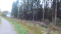
The northerly section section past the power lines between Trosterbekk & Gudim, has the some of most technical trails in at Prestegårdsskogen,
But the the Prestegårdsskogen, also has easier trails, but has steep trails too, some of the trails are old tractor trails.
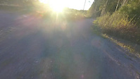
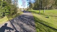
The area around Askim Hallen has very wide lit ski tracks, and few short trails, from easy to hard.
There are nice lit ski tracks, most are easy, and are suited for the family, but the but the track goign from the turnaround down to the underpass is steep and can be muddy after heavy rain.
the track down from the first rest stop at the top is also steep.
The lights turn off at 23:00.
Norwegian:
Prestegårdsskogen, er skogen rundt Askim Kirke,
Den nordligste delen av skogen forbi strømlinja mellom Trosterbekk og Gudim, har de noen av de mest tekniske stiene i Prestegårdsskogen.
men Prestegårdsskogen har også lette stier, men har bratte stier også, noen av stiene er gamle traktor stier.
Området ved Askim hallen har veldig bred lysløype, og flere korte stiene fra lette til vanskelige.
Det er fine ski lysløyper,de fleste er lette og passer fint for hele familien, men løypa som går fra snuplassen , ned mot undergangen er bratt, og kan være gjørmete etter regn.
løypa fra den første rasteplassen er bratt.
Lyset slukkes 23.00.
The northerly section section past the power lines between Trosterbekk & Gudim, has the some of most technical trails in at Prestegårdsskogen,
But the the Prestegårdsskogen, also has easier trails, but has steep trails too, some of the trails are old tractor trails.
The area around Askim Hallen has very wide lit ski tracks, and few short trails, from easy to hard.
There are nice lit ski tracks, most are easy, and are suited for the family, but the but the track goign from the turnaround down to the underpass is steep and can be muddy after heavy rain.
the track down from the first rest stop at the top is also steep.
The lights turn off at 23:00.
Norwegian:
Prestegårdsskogen, er skogen rundt Askim Kirke,
Den nordligste delen av skogen forbi strømlinja mellom Trosterbekk og Gudim, har de noen av de mest tekniske stiene i Prestegårdsskogen.
men Prestegårdsskogen har også lette stier, men har bratte stier også, noen av stiene er gamle traktor stier.
Området ved Askim hallen har veldig bred lysløype, og flere korte stiene fra lette til vanskelige.
Det er fine ski lysløyper,de fleste er lette og passer fint for hele familien, men løypa som går fra snuplassen , ned mot undergangen er bratt, og kan være gjørmete etter regn.
løypa fra den første rasteplassen er bratt.
Lyset slukkes 23.00.
 google parking directions
This region uses the Uk/Euro style trail grading system.
Activities Click to view
- Mountain Bike
156 trails
- E-Bike
138 trails
- Hike
154 trails
- Trail Running
153 trails
- Dirtbike/Moto
2 trails
- ATV/ORV/OHV
2 trails
- Nordic Ski
14 trails
Region Details
- 20
- 47
- 56
- 2
- 3
Region Status
Caution as of Jun 24, 2022Stats
- Avg Trail Rating
- Trails (view details)
- 157
- Trails Mountain Bike
- 156
- Trails E-Bike
- 138
- Trails Hike
- 154
- Trails Trail Running
- 153
- Trails Dirtbike/Moto
- 2
- Trails ATV/ORV/OHV
- 2
- Trails Snowmobile
- 1
- Trails Nordic Ski
- 14
- Total Distance
- 13 miles
- Total Descent
- 1,169 ft
- Total Vertical
- 246 ft
- Highest Trailhead
- 523 ft
- Reports
- 578
- Photos
- 731
- Ridden Counter
- 288
Popular Prestegårdsskogen Mountain Biking Trails
Prestegårdsskogen Mountain Bike Routes
| title | rating | distance |
|---|---|---|
| Lysløypa 1,9 | 1 mile | |
| Løyperetning 2,5 | 1 mile | |
| Lysløypa 3,5 km | 2 miles |
Photos of Prestegårdsskogen Mountain Bike
trail: Røtter og trangt
10 |
Oct 19, 2018 @ 4:29pm
Oct 19, 2018
trail: Bob Marley's Corner
6 |
Oct 19, 2018 @ 12:51pm
Oct 19, 2018
trail: Fra lys løype og tilbake
8 |
Oct 18, 2018 @ 7:50pm
Oct 18, 2018
trail: Fra lys løype og tilbake
7 |
Oct 18, 2018 @ 7:50pm
Oct 18, 2018
trail: Forbi benkene til snuplassen
23 |
Aug 7, 2018 @ 6:21pm
Aug 7, 2018
trail: Trostebekk Gård Grassti
18 |
Jun 22, 2018 @ 4:11pm
Jun 22, 2018
trail: Bob Marley's Corner
5 |
Jul 11, 2017 @ 2:26pm
Jul 11, 2017Videos of Prestegårdsskogen Mountain Bike

25:35 |
17 |
Nov 17, 2016
trail: Trostebekk Gård Grassti
1:37 |
5 |
Oct 27, 2016
4:13 |
15 |
Oct 26, 2016
trail: Ned i skogen
6:36 |
15 |
Oct 23, 2016
trail: Gudim Runden
6:05 |
15 |
Oct 21, 2016
trail: Røtter og trangt
3:47 |
8 |
Oct 17, 2016
1:40 |
7 |
Oct 3, 2016
trail: Langs parkerings plassen
0:57 |
2 |
Oct 3, 2016
Current Trail Warnings
| status | trail | date | condition | user | info |
|---|---|---|---|---|---|
| Sollia - Baglerfaret | Jun 24, 2022 @ 2:26pm Jun 24, 2022 | Dry | mtbboy1993 TRAILFORKS | No: Veldig overgrodd, deler av trær... |
Recent Trail Reports
| status | trail | date | condition | info | user |
|---|---|---|---|---|---|
| Forbi Vesletunet | Jun 24, 2022 @ 2:35pm Jun 24, 2022 | Variable | mtbboy1993 TRAILFORKS | ||
| Kirkegata | May 27, 2022 @ 3:41am May 27, 2022 | Ideal | mtbboy1993 TRAILFORKS | ||
| Skateparken Rådhuset | Dec 16, 2021 @ 5:16pm Dec 16, 2021 | Ideal | mtbboy1993 TRAILFORKS | ||
| Zebra DH | Dec 16, 2021 @ 10:46am Dec 16, 2021 | Ideal | mtbboy1993 TRAILFORKS | ||
| Folkeparken Corner | Dec 16, 2021 @ 10:44am Dec 16, 2021 | Variable | mtbboy1993 TRAILFORKS | ||
| Endo turn rock | Sep 2, 2021 @ 7:46pm Sep 2, 2021 | Variable | mtbboy1993 TRAILFORKS | ||
| Vest til Nord-Øst for tennis banene | Aug 29, 2021 @ 12:47pm Aug 29, 2021 | Variable | mtbboy1993 TRAILFORKS | ||
| Rebound | Aug 25, 2021 @ 5:14am Aug 25, 2021 | Ideal | mtbboy1993 TRAILFORKS | ||
| Fra Bålplassen nord-vest | Aug 25, 2021 @ 5:11am Aug 25, 2021 | Ideal | mtbboy1993 TRAILFORKS | ||
| Ned mellom trær | Aug 25, 2021 @ 5:10am Aug 25, 2021 | Variable | mtbboy1993 TRAILFORKS |
Activity Feed
| username | action | type | title | date | |
|---|---|---|---|---|---|
 | mtbboy1993 | add | report | Sollia - Baglerfaret and 2 more | Jun 24, 2022 @ 2:26pm Jun 24, 2022 |
| mtbboy1993 | update | trail | Hulvei | Jun 2, 2022 @ 4:42am Jun 2, 2022 |
| mtbboy1993 | add | report | Kirkegata | May 27, 2022 @ 3:42am May 27, 2022 |
| mtbboy1993 | update | trail | Belegningsstein Stien | May 27, 2022 @ 3:39am May 27, 2022 |
| mtbboy1993 | add | photo | in Askim, Norway and 1 more | May 27, 2022 @ 3:34am May 27, 2022 |
Nearby Areas
| name | distance | ||||
|---|---|---|---|---|---|
| Askim Museum | 11 | 5 | 1 km | ||
| Kråkåsen | 11 | 15 | 1 km | ||
| Langnes | 2 | 9 | 4 | 1.2 km | |
| Hovskogen | 44 | 25 | 4 | 1.4 km | |
| Hundremeterskogen | 15 | 11 | 3 | 1.4 km |
Local Badges
-

Completionist0 awarded
Bike & Skill Parks
| name | type | city | rating |
|---|---|---|---|
| Pumptrack Askim | skill park | Askim |
Activity Type Stats
| activitytype | trails | distance | descent | descent distance | total vertical | rating | global rank | state rank | photos | reports | routes | ridelogs |
|---|---|---|---|---|---|---|---|---|---|---|---|---|
| Mountain Bike | 156 | 13 miles | 1,168 ft | 4 miles | 246 ft | #2,688 | #5 | 731 | 575 | 3 | 140 | |
| E-Bike | 138 | 12 miles | 1,135 ft | 4 miles | 246 ft | #1,027 | #8 | 563 | 2 | |||
| Hike | 154 | 13 miles | 1,168 ft | 4 miles | 246 ft | #2,114 | #2 | 574 | 2 | |||
| Trail Running | 153 | 13 miles | 1,168 ft | 4 miles | 246 ft | #2,152 | #2 | 574 | 2 | 2 | ||
| Dirtbike/Moto | 2 | 3,802 ft | 13 ft | 466 ft | 92 ft | #2 | 454 | |||||
| ATV/ORV/OHV | 2 | 3,802 ft | 13 ft | 466 ft | 92 ft | #3 | 454 | |||||
| Snowmobile | 1 | 1,329 ft | 3 ft | 85 ft | 13 ft | |||||||
| Nordic Ski | 14 | 3 miles | 285 ft | 1 mile | 207 ft | #73 | #4 | 12 | 2 |
- By mtbboy1993
 TRAILFORKS SSK & contributors
 - Admins: apply
- #15075 - 5,634 views
- prestegårdsskogen activity log | embed map of Prestegårdsskogen mountain bike trails | prestegårdsskogen mountain biking points of interest polygons
Downloading of trail gps tracks in kml & gpx formats is enabled for Prestegårdsskogen.
You must login to download files.