3,330 ft
Distance
-536 ft
Descent
00:07:17
Avg time
Supporters, Builders, Maintainers & Land Managers of John Deer Trail

Knolly Bikes
since 2019Sponsor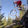
Martin Newman
since 2016Maintainer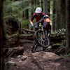
Penny Deck
since 2016Maintainer- past supporters

BC Bike Race
2018Sponsor- nvantrails@gmail.com
2010 - 2012Builder
John Deer Details
-
Activities
- Mountain Bike
- Hike
- Trail Running
-
Riding AreaMount Seymour
North Vancouver, British Columbia -
AKAJD Red Truck
-
Difficulty Rating
-
Voted DifficultyBlue (2 votes)
-
Trail TypeSingletrack
-
Bike TypeDH, AM, XC
-
DirectionDownhill OnlyPopular direction shown
-
Dogs AllowedYes
-
eBike Allowed
-
TTFs on TrailA-Frame, Bridge, Jump
-
Global Ranking
-
Local Popularity100 in Mountain Biking [+]
- 70 in Trail Running
- 75 in Hiking
-
Land ManagerCMHC
Fast flowy singletrack with lots of berms and a few small jumps. Optional black features. Please stay away when the ground is saturated.
The trail is downhill only for mountain bikers. Do not ride uphill.
Access Info
Accessed half way up Good Sir Martin where it crosses John Deer or also "Blue" access from Power Line Access/ via Upper Severed, Dickie, Severed D, Upper John Deer
Local Trail Association
-

-

-
Please consider joining or donating to the local trail association to supportdonate to earn trail karma!
trail development & maintenance.
Traditionally Indigenous Territory
More Stats for John Deer mountain bike trail trail
-
Altitude change-537 ft
-
Altitude min734 ft
-
Altitude max1,271 ft
-
Altitude start1,271 ft
-
Altitude end735 ft
-
Grade-16.1%
-
Grade max-56.3%
-
Grade min-0.6%
-
Distance down3,228 ft
-
Avg time00:07:17
-
Avg reverse time00:11:27
- view trail stats
close
Trail Conditions
- Unknown
- Snow Groomed
- Snow Packed
- Snow Covered
- Snow Cover Inadequate
- Freeze/thaw Cycle
- Icy
- Prevalent Mud
- Wet
- Variable
- Ideal
- Dry
- Very Dry
Trail Flow (Ridden Direction)
Trailforks scans users ridelogs to determine the most popular direction each trail is ridden. A good flowing trail network will have most trails flowing in a single direction according to their intension.
The colour categories are based on what percentage of riders are riding a trail in its intended direction.
The colour categories are based on what percentage of riders are riding a trail in its intended direction.
- > 96%
- > 90%
- > 80%
- > 70%
- > 50%
- < 50%
- bi-directional trail
- no data
Trail Last Ridden
Trailforks scans ridelogs to determine the last time a trail was ridden.
- < 2 days
- < 1 week
- < 2 weeks
- < 1 month
- < 6 months
- > 6 months
Trail Ridden Direction
The intended direction a trail should be ridden.
- Downhill Only
- Downhill Primary
- Both Directions
- Uphill Primary
- Uphill Only
- One Direction
Contribute Details
Colors indicate trail is missing specified detail.
- Description
- Photos
- Description & Photos
- Videos
Trail Popularity ?
Trailforks scans ridelogs to determine which trails are ridden the most in the last 9 months.
Trails are compared with nearby trails in the same city region with a possible 25 colour shades.
Think of this as a heatmap, more rides = more kinetic energy = warmer colors.
- most popular
- popular
- less popular
- not popular
ATV/ORV/OHV Filter
Max Vehicle Width
inches
Radar Time
x
Activity Recordings
Trailforks users anonymized public ridelogs from the past 6 months.
- mountain biking recent
- mountain biking (>6 month)
- hiking (1 year)
- moto (1 year)
Activity Recordings
Trailforks users anonymized public skilogs from the past 12 months.
- Downhill Ski
- Backcountry Ski
- Nordic Ski
Jump Magnitude Heatmap
Heatmap of where riders jump on trails. Zoom in to see individual jumps, click circles to view jump details.
Trails Deemphasized
Trails are shown in grey.
Only show trails with NO bikes.
Save the current map location and zoom level as your default home location whenever this page is loaded.
Save
Directions to john-deer trailhead
(49.335270, -122.980560)
update trails status or condition
John Deer Trail Reports
view all reports »
Recent Ridelog Activity on Trail
Past Week
- 137 rides
- 8 miles avg distance
6 Months
- 4,175 rides
- 8 miles avg distance
All
- 31,614 rides
Technical Trail Features (TTF)
- Buck Huck
 Drop
Drop - Buck Shot Gap Jump
- is it a bridge or is it a Ladder Bridge
Photos
more »
Trail Lists
-
Mount Seymour
57 trails
-
MOUNT SEYMOUR
7 trails
Routes with this trail
more »
Trail Events
Trail Products
-
+ 2
 gregmowat
Not wet weather friendly, maybe in the past but not now. Just finished great run in light rain..
[Reply]
 leelau
Originally built by Bryce Borlick in 2011 www.pinkbike.com/video/434491
Ridden respectfully and mainly in the dry for 4 glorious years. Shut down in 2014-5. Re-opened and given new life by Martin & Penny.
[Reply]
Ridden respectfully and mainly in the dry for 4 glorious years. Shut down in 2014-5. Re-opened and given new life by Martin & Penny.
Videos
more »


Nearby Trails
- Deer John 512 ft
- Upper John Deer 584 ft
- Asian Adonis 827 ft
- C-buster 1,663 ft
- Shorn Scrotum 1,850 ft
- embed John Deer trail on your website
- By canadaka
 Trailforks & contributors
 - #3231 - 35,735 views
- subscribe
- login to download gpx or kml files.