4,441 ft
Distance
431 ft
Climb
-40 ft
Descent
00:14:57
Avg time
Supporters, Builders, Maintainers & Land Managers of Good Sir Martin Trail

Accent InnsSponsor
Martin Newman
since 2014Builder
Penny Deck
since 2014Builder
Good Sir Martin Details
-
Activities
- Mountain Bike
- Hike
- Trail Running
-
Riding AreaMount Seymour
North Vancouver, British Columbia -
AKAGSM, Good Sir
-
Difficulty Rating
-
Trail TypeSingletrack
-
Bike TypeAM, XC
-
DirectionUphill OnlyPopular direction shown
-
Climb DifficultyBlue
-
Physical RatingModerate
-
SeasonYear Round
-
Dogs AllowedYes
-
TTFs on TrailBridge
-
Ride in RainYes
-
Global Ranking
-
Local Popularity100 in Mountain Biking [+]
- 85 in Trail Running
- 80 in Hiking
-
Year Opened2015
-
Land ManagerCMHC
Single track trail, bike traffic is uphill only; foot traffic is either direction.
Access Info
Starts on Severed D, opposite the top of Penny Lane and climbs to Baden Powell trail just above the Boogieman entrance
Local Trail Association
-

-

-
Please consider joining or donating to the local trail association to supportdonate to earn trail karma!
trail development & maintenance.
Traditionally Indigenous Territory
More Stats for Good Sir Martin mountain bike trail trail
-
Altitude change391 ft
-
Altitude min993 ft
-
Altitude max1,384 ft
-
Altitude start993 ft
-
Altitude end1,384 ft
-
Grade8.805%
-
Grade max-14.808%
-
Grade min26.524%
-
Distance climb3,457 ft
-
Distance down605 ft
-
Distance flat379 ft
-
Avg time00:14:57
-
Avg reverse time00:19:39
- view trail stats
close
Trail Conditions
- Unknown
- Snow Groomed
- Snow Packed
- Snow Covered
- Snow Cover Inadequate
- Freeze/thaw Cycle
- Icy
- Prevalent Mud
- Wet
- Variable
- Ideal
- Dry
- Very Dry
Trail Flow (Ridden Direction)
Trailforks scans users ridelogs to determine the most popular direction each trail is ridden. A good flowing trail network will have most trails flowing in a single direction according to their intension.
The colour categories are based on what percentage of riders are riding a trail in its intended direction.
The colour categories are based on what percentage of riders are riding a trail in its intended direction.
- > 96%
- > 90%
- > 80%
- > 70%
- > 50%
- < 50%
- bi-directional trail
- no data
Trail Last Ridden
Trailforks scans ridelogs to determine the last time a trail was ridden.
- < 2 days
- < 1 week
- < 2 weeks
- < 1 month
- < 6 months
- > 6 months
Trail Ridden Direction
The intended direction a trail should be ridden.
- Downhill Only
- Downhill Primary
- Both Directions
- Uphill Primary
- Uphill Only
- One Direction
Contribute Details
Colors indicate trail is missing specified detail.
- Description
- Photos
- Description & Photos
- Videos
Trail Popularity ?
Trailforks scans ridelogs to determine which trails are ridden the most in the last 9 months.
Trails are compared with nearby trails in the same city region with a possible 25 colour shades.
Think of this as a heatmap, more rides = more kinetic energy = warmer colors.
- most popular
- popular
- less popular
- not popular
ATV/ORV/OHV Filter
Max Vehicle Width
inches
Radar Time
x
Activity Recordings
Trailforks users anonymized public ridelogs from the past 6 months.
- mountain biking recent
- mountain biking (>6 month)
- hiking (1 year)
- moto (1 year)
Activity Recordings
Trailforks users anonymized public skilogs from the past 12 months.
- Downhill Ski
- Backcountry Ski
- Nordic Ski
Jump Magnitude Heatmap
Heatmap of where riders jump on trails. Zoom in to see individual jumps, click circles to view jump details.
Trails Deemphasized
Trails are shown in grey.
Only show trails with NO bikes.
Save the current map location and zoom level as your default home location whenever this page is loaded.
Save
Directions to good-sir-martin trailhead
(49.331860, -122.983190)
update trails status or condition
Good Sir Martin Trail Reports
view all reports »
Recent Ridelog Activity on Trail
Past Week
- 148 rides
- 8 miles avg distance
6 Months
- 4,615 rides
- 8 miles avg distance
All
- 39,593 rides
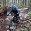
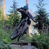
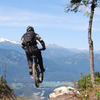
Photos
more »
Trail Lists
-
 CMHC Trails35 trails
 -
Mount Seymour
57 trails
Routes with this trail
more »
Trail Products
-
+ 2
Mcyeetus
(Oct 20, 2021 at 19:37)
Fun and enjoyable climb.
[Reply]
 liamdubs
Please make sure to ring the bell at the intersection of John Deer and Good Sir Martin. If you don't ring the bell your strava/trailforks ride will NOT record this trail. It's real important to ring the bell.
[Reply]
 pinker001
Challenging and enjoyable. The trail is pretty steep in some sections with tight switchbacks at steep grade with some rocks to traverse coming through the switchbacks. Physically and technically challenging. I find myself clipping rocks with my pedals and have yet to ride the whole thing without putting a foot down, but I’ll keep trying.
[Reply]
bboyshredder
(Aug 28, 2019 at 17:50)
I love this trail . if you hate climbing stick to the old buck because its way shorter. but its awesome and smooth but penny lane isn't witch is before good sir Martin. not good for bigginer climbers .
[Reply]

 meloroast
this trail rides like a dream. absolutely love it! great work!!
[Reply]
 CRich78
Phenomenal climbing trail. Thanks for all the beautiful work Martin and Penny. Rode GSM for the first time today and enjoyed every inch of it. It's so great to be able to loop back to Baden without having to head over to Old Buck or Hyannis. Awesome. I'll definitely be heading up to ride some Seymour loops more often. Thanks again!
[Reply]
 DMal
DMal
Great climbing trail. It climbs through a beautiful part of the forest, and the grade is nice and moderate.
[Reply]
moballa
 (Jul 12, 2015 at 21:01)
My son and I rode Good Sir this morning which allowed us to do a couple of laps up there which doesn't happen often for us. The trail meanders beautifully through pristine forest and feels like it's been there forever - a testament to the fantastic engineering and careful planning that went into this right down to the precise fern transplanting! "Isn't this awesome!" was echoed by many of the other excited riders we encountered along the trail today. Congratulations Martin and Penny and to all the other volunteers! Good Sir Martin will be one of the most enjoyed trails on the north shore.
[Reply]
 frenchfriedfun
the Christmas corner is sick ! and the bunch after that too..
sick trail
[Reply]
sick trail
Videos
more »


Nearby Trails
- Shorn Scrotum 394 ft
- Lower C-buster 1,165 ft
- Pussyfoot 1,198 ft
- Penny Lane 1,240 ft
- Applicator 1,253 ft
- embed Good Sir Martin trail on your website
- By goodsirmartin SHORE CORPS NSMBA & contributors
- #25195 - 29,203 views
- subscribe
- login to download gpx or kml files.