590 ft
Distance
-101 ft
Descent
00:01:19
Avg time
Fade to Black Details
-
Activities
- Mountain Bike
-
Riding AreaWhistler Mountain Bike Park
Whistler, British Columbia -
Difficulty Rating
-
Voted DifficultyDouble Black Diamond (4 votes)
-
Trail TypeSingletrack
-
Bike TypeDH, AM
-
DirectionDownhill OnlyPopular direction shown
-
TTFs on TrailBridge, Drop, Jump
-
Global Ranking#34 in Mountain Biking
-
Local Popularity95 in Mountain Biking
-
Land Manager
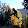
Short dangerous trail if you are not prepared. Starts w/ legendary road gap, then a smaller drop over a stump, then a do or die step-up/step-down after that you give high fives.
Bike Park
Traditionally Indigenous Territory
More Stats for Fade to Black mountain bike trail trail
-
Altitude change-101 ft
-
Altitude min3,084 ft
-
Altitude max3,185 ft
-
Altitude start3,185 ft
-
Altitude end3,084 ft
-
Grade max-36.403%
-
Grade min-4.498%
-
Distance down590 ft
-
Avg time00:01:19
-
Avg reverse time00:57:57
- view trail stats
close
Trail Conditions
- Unknown
- Snow Groomed
- Snow Packed
- Snow Covered
- Snow Cover Inadequate
- Freeze/thaw Cycle
- Icy
- Prevalent Mud
- Wet
- Variable
- Ideal
- Dry
- Very Dry
Trail Flow (Ridden Direction)
Trailforks scans users ridelogs to determine the most popular direction each trail is ridden. A good flowing trail network will have most trails flowing in a single direction according to their intension.
The colour categories are based on what percentage of riders are riding a trail in its intended direction.
The colour categories are based on what percentage of riders are riding a trail in its intended direction.
- > 96%
- > 90%
- > 80%
- > 70%
- > 50%
- < 50%
- bi-directional trail
- no data
Trail Last Ridden
Trailforks scans ridelogs to determine the last time a trail was ridden.
- < 2 days
- < 1 week
- < 2 weeks
- < 1 month
- < 6 months
- > 6 months
Trail Ridden Direction
The intended direction a trail should be ridden.
- Downhill Only
- Downhill Primary
- Both Directions
- Uphill Primary
- Uphill Only
- One Direction
Contribute Details
Colors indicate trail is missing specified detail.
- Description
- Photos
- Description & Photos
- Videos
Trail Popularity ?
Trailforks scans ridelogs to determine which trails are ridden the most in the last 9 months.
Trails are compared with nearby trails in the same city region with a possible 25 colour shades.
Think of this as a heatmap, more rides = more kinetic energy = warmer colors.
- most popular
- popular
- less popular
- not popular
ATV/ORV/OHV Filter
Max Vehicle Width
inches
Radar Time
x
Activity Recordings
Trailforks users anonymized public ridelogs from the past 6 months.
- mountain biking recent
- mountain biking (>6 month)
- hiking (1 year)
- moto (1 year)
Activity Recordings
Trailforks users anonymized public skilogs from the past 12 months.
- Downhill Ski
- Backcountry Ski
- Nordic Ski
Jump Magnitude Heatmap
Heatmap of where riders jump on trails. Zoom in to see individual jumps, click circles to view jump details.
Trails Deemphasized
Trails are shown in grey.
Only show trails with NO bikes.
Save the current map location and zoom level as your default home location whenever this page is loaded.
Save
Directions to fade-to-black trailhead
(50.100510, -122.953990)
update trails status or condition
Fade to Black Trail Reports
view all reports »
Recent Ridelog Activity on Trail
Past Week
- 249 rides
- 23 miles avg distance
6 Months
- 1,448 rides
- 24 miles avg distance
All
- 18,159 rides
Photos
more »
Trail Lists
-
2020 goals
10 trails
-
Whistler Bike Park Freeride Trails
33 trails
Trail Products

Videos
more »


Nearby Trails
- Karate Monkey 486 ft
- Funshine Rolly Drops 627 ft
- Ninja Cougar 676 ft
- Angry Pirate - Lower 774 ft
- Smoke And Mirrors 781 ft
Whistler Mountain Bike Park
- embed Fade to Black trail on your website
- By todayisthegreatest & contributors
- #7786 - 13,755 views
- subscribe
- login to download gpx or kml files.