Supporters, Builders, Maintainers & Land Managers of Upper Severed Trail
Martin NewmanBuilder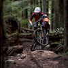
Penny DeckBuilder
Upper Severed Details
-
Activities
- Mountain Bike
- Hike
- Trail Running
-
Riding AreaMount Seymour
North Vancouver, British Columbia -
AKANew Severed Entrance
-
Difficulty Rating
-
Trail TypeSingletrack
-
Bike TypeAM, XC
-
DirectionDownhill OnlyPopular direction shown
-
Physical RatingEasy
-
SeasonYear round
-
Dogs AllowedYes
-
Ride in RainYes
-
Global Ranking
-
Local Popularity85 in Mountain Biking [+]
- 55 in Trail Running
- 75 in Hiking
-
Year Opened2014
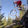
Fun, flowy trail that connects to the start of Severed D. Option to link with Dickie to bypass the steep section at the start of Severed. Riders seeking a similar smooth flowy riding experience are recommended to continue to Asian Adonis (accessed via C-Buster off Severed) or John Deer. Continuing along Severed offers more technical challenge with rocky descents and several low to the ground optional skinnies.
Riders also have the option of turning right at the junction with the Baden Powell to connect to Forever After.
The trail is downhill only for mountain bikers. Do not ride uphill.
Access Info
Descending from the power line from the junction with Mushroom Trail look for the single track entrance on the left.
Local Trail Association
-

-

-
Please consider joining or donating to the local trail association to supportdonate to earn trail karma!
trail development & maintenance.
Traditionally Indigenous Territory
More Stats for Upper Severed mountain bike trail trail
-
Altitude change-9 ft
-
Altitude min1,393 ft
-
Altitude max1,402 ft
-
Altitude start1,402 ft
-
Altitude end1,394 ft
-
Grade-2.2%
-
Grade max-4.3%
-
Grade min0.8%
-
Distance down240 ft
-
Distance flat92 ft
-
Avg time00:00:36
-
Avg reverse time00:03:15
- view trail stats
- Unknown
- Snow Groomed
- Snow Packed
- Snow Covered
- Snow Cover Inadequate
- Freeze/thaw Cycle
- Icy
- Prevalent Mud
- Wet
- Variable
- Ideal
- Dry
- Very Dry
The colour categories are based on what percentage of riders are riding a trail in its intended direction.
- > 96%
- > 90%
- > 80%
- > 70%
- > 50%
- < 50%
- bi-directional trail
- no data
- < 2 days
- < 1 week
- < 2 weeks
- < 1 month
- < 6 months
- > 6 months
- Downhill Only
- Downhill Primary
- Both Directions
- Uphill Primary
- Uphill Only
- One Direction
- Description
- Photos
- Description & Photos
- Videos
- most popular
- popular
- less popular
- not popular
- mountain biking recent
- mountain biking (>6 month)
- hiking (1 year)
- moto (1 year)
- Downhill Ski
- Backcountry Ski
- Nordic Ski
Save the current map location and zoom level as your default home location whenever this page is loaded.
SaveUpper Severed Trail Reports
Recent Ridelog Activity on Trail
Past Week
- 17 rides
- 8 miles avg distance
6 Months
- 683 rides
- 8 miles avg distance
All
- 27,402 rides
Videos

Nearby Trails
- Dickie 433 ft
- Severed D 433 ft
- C-buster 797 ft
- Dale's Rock 1,752 ft
- Bp To Powerline Connector 1,883 ft
- embed Upper Severed trail on your website
- By canadaka
 Trailforks & contributors
 - #3429 - 9,540 views
- subscribe
- login to download gpx or kml files.
Don’t be caught of guard by sudden climbs