close
Trail Conditions
- Unknown
- Snow Groomed
- Snow Packed
- Snow Covered
- Snow Cover Inadequate
- Freeze/thaw Cycle
- Icy
- Prevalent Mud
- Wet
- Variable
- Ideal
- Dry
- Very Dry
Trail Flow (Ridden Direction)
Trailforks scans users ridelogs to determine the most popular direction each trail is ridden. A good flowing trail network will have most trails flowing in a single direction according to their intension.
The colour categories are based on what percentage of riders are riding a trail in its intended direction.
The colour categories are based on what percentage of riders are riding a trail in its intended direction.
- > 96%
- > 90%
- > 80%
- > 70%
- > 50%
- < 50%
- bi-directional trail
- no data
Trail Last Ridden
Trailforks scans ridelogs to determine the last time a trail was ridden.
- < 2 days
- < 1 week
- < 2 weeks
- < 1 month
- < 6 months
- > 6 months
Trail Ridden Direction
The intended direction a trail should be ridden.
- Downhill Only
- Downhill Primary
- Both Directions
- Uphill Primary
- Uphill Only
- One Direction
Contribute Details
Colors indicate trail is missing specified detail.
- Description
- Photos
- Description & Photos
- Videos
Trail Popularity ?
Trailforks scans ridelogs to determine which trails are ridden the most in the last 9 months.
Trails are compared with nearby trails in the same city region with a possible 25 colour shades.
Think of this as a heatmap, more rides = more kinetic energy = warmer colors.
- most popular
- popular
- less popular
- not popular
ATV/ORV/OHV Filter
Max Vehicle Width
inches
Radar Time
x
Activity Recordings
Trailforks users anonymized public ridelogs from the past 6 months.
- mountain biking recent
- mountain biking (>6 month)
- hiking (1 year)
- moto (1 year)
Activity Recordings
Trailforks users anonymized public skilogs from the past 12 months.
- Downhill Ski
- Backcountry Ski
- Nordic Ski
Jump Magnitude Heatmap
Heatmap of where riders jump on trails. Zoom in to see individual jumps, click circles to view jump details.
Trails Deemphasized
Trails are shown in grey.
Only show trails with NO bikes.
Save the current map location and zoom level as your default home location whenever this page is loaded.
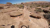
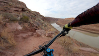
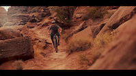
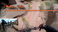
SaveSome of Moab's best enduro riding and most spectacular scenery, located so close to town you don't even need a car. Hit Ahab for a quick loop after work, session it a few times, or hit Jackson's for incredible views of the Colorado River.
NOTE: No ebikes or motors of any kind on the singletrack
NOTE: No ebikes or motors of any kind on the singletrack
Primary Trail Type: All-Mountain & Downhill
eBikes Allowed:
No
Land Manager: BLM
 google parking directions
 Region Supporters & Maintainers
![Moab Trail Mix]()
Moab Trail MixMaintainer
Activities Click to view
- Mountain Bike
21 trails
- E-Bike
3 trails
- Hike
26 trails
- Trail Running
26 trails
- Horse
0 trails
Region Details
- 4
- 2
- 3
- 7
- 5
Region Status
Open as of Jun 8, 2021Local Trail Association
Stats
- Avg Trail Rating
- Trails (view details)
- 25
- Trails Mountain Bike
- 21
- Trails E-Bike
- 3
- Trails Hike
- 26
- Trails Trail Running
- 26
- Trails Dirtbike/Moto
- 3
- Trails ATV/ORV/OHV
- 3
- Total Distance
- 33 miles
- Total Descent
- 5,637 ft
- Total Vertical
- 1,021 ft
- Highest Trailhead
- 4,967 ft
- Reports
- 605
- Photos
- 528
- Ridden Counter
- 33,331
Popular Amasa Back Mountain Biking Trails
Amasa Back Mountain Bike Routes
| title | rating | distance |
|---|---|---|
| Hymasa/Captain Ahab loop | 8 miles | |
| Trail One List - Captain Ahab | 9 miles | |
| Amasa Back - Pothole Arch, Captain Ahab, Cliff Hanger, Hymasa - RideSpots.com | 14 miles | |
| Half Ahab Loop | 6 miles | |
| Captain Ahab via Cliff Hanger | 7 miles | |
| Pothole Stacker Ahab | 15 miles | |
| GU Getaway Day 1 Half | 6 miles | |
| Moab Trip - Ahab with Rockstacker | 13 miles | |
| GU Getaway Day 1 Full | 13 miles | |
| 13 mile Amasa Back Ride | popular ridelog | 13 miles |
Photos of Amasa Back Mountain Bike
trail: Captain Ahab (lower)
1,277 |
Jan 19, 2018 @ 2:01pm
Jan 19, 2018
trail: Pothole Arch
164 |
Jan 7, 2018 @ 12:14pm
Jan 7, 2018
trail: HyMasa
339 |
Jan 18, 2017 @ 2:52pm
Jan 18, 2017
trail: Captain Ahab (lower)
741 |
Jan 18, 2017 @ 2:33pm
Jan 18, 2017
trail: HyMasa
227 |
Jan 18, 2017 @ 2:33pm
Jan 18, 2017
trail: Rockstacker
555 |
Jun 15, 2016 @ 10:37am
Jun 15, 2016
trail: HyMasa (upper)
186 |
Dec 23, 2015 @ 6:43am
Dec 23, 2015
trail: Rockstacker
600 |
Oct 1, 2015 @ 6:48am
Oct 1, 2015Videos of Amasa Back Mountain Bike
trail: Captain Ahab (lower)
104 |
Mar 26, 2022
trail: Captain Ahab (lower)
17 |
Dec 2, 2020

trail: Captain Ahab (lower)
8:08 |
56 |
Feb 22, 2020
trail: Jackson
0:39 |
128 |
Dec 10, 2019
trail: Captain Ahab (lower)
2:05 |
281 |
Feb 21, 2018

trail: Captain Ahab (lower)
1:02 |
93 |
Feb 11, 2018
trail: Captain Ahab (lower)
5:23 |
74 |
Jan 15, 2018

trail: Captain Ahab (lower)
4:14 |
61 |
Oct 18, 2017
Recent Trail Reports
| status | trail | date | condition | info | user |
|---|---|---|---|---|---|
| Cliff Hanger | Jun 8, 2021 @ 8:00am Jun 8, 2021 | Dry | GrandCountyTrails MTM | ||
| Hunter Rim | Jun 8, 2021 @ 8:00am Jun 8, 2021 | Dry | GrandCountyTrails MTM | ||
| Hunter Rim | Jun 8, 2021 @ 8:00am Jun 8, 2021 | Dry | GrandCountyTrails MTM | ||
| Jackson (hole) | Jun 8, 2021 @ 8:00am Jun 8, 2021 | Dry | GrandCountyTrails MTM | ||
| Jackson Hole | Jun 8, 2021 @ 8:00am Jun 8, 2021 | Dry | GrandCountyTrails MTM | ||
| Amasa River Overlook | Jun 8, 2021 @ 8:00am Jun 8, 2021 | Dry | GrandCountyTrails MTM |
Activity Feed
| username | action | type | title | date | |
|---|---|---|---|---|---|
 | javmant | wishlist | route | Trail One List - Captain Ahab | Jul 4, 2022 @ 1:48pm 2 days |
 | javadown1969 | add | report | Amasa Back access and 4 more | Jul 3, 2022 @ 9:22pm 2 days |
 | jhillsmtb | add | photo | in North Vancouver, British Columbia, Canada and 1 more | Jul 2, 2022 @ 10:14pm Jul 2, 2022 |
 | Shafto | vote | trail | Captain Ahab (upper) | Jul 2, 2022 @ 7:14am Jul 2, 2022 |
| swagnerrr | wishlist | trail | Captain Ahab (upper) and 1 more | Jun 30, 2022 @ 10:06pm Jun 30, 2022 |
Recent Comments
| username | type | title | comment | date | |
|---|---|---|---|---|---|
 | trail | More flowy and rock rolls, drops and less... | May 29, 2022 @ 3:53pm May 29, 2022 | ||
| trail | More tech and janky rock rolls, drops and... | May 29, 2022 @ 3:51pm May 29, 2022 | ||
 | trail | One of the best trails in Moab. If you do the... | May 15, 2022 @ 5:38am May 15, 2022 | ||
| trail | You don't need to cross the creek at the end... | Apr 30, 2022 @ 12:35pm Apr 30, 2022 | ||
| trail | Super sick classic Moab trail. Located a mile... | Apr 11, 2022 @ 4:31pm Apr 11, 2022 |
Nearby Areas
| name | distance | ||||
|---|---|---|---|---|---|
| Mag 7 | 2 | 10 | 3 | 3 | 5.3 km |
| Sand Flats Recreation Area | 1 | 12 | 4 | 1 | 6.3 km |
| Dead Horse Point | 4 | 6 | 6.8 km | ||
| Moab Brand Trails | 9 | 10 | 4 | 1 | 9.5 km |
| Horsethief | 6 | 10 | 11.1 km |
Local Badges
-

Completionist2 awarded
Activity Type Stats
| activitytype | trails | distance | descent | descent distance | total vertical | rating | global rank | state rank | photos | reports | routes | ridelogs |
|---|---|---|---|---|---|---|---|---|---|---|---|---|
| Mountain Bike | 21 | 28 miles | 5,033 ft | 12 miles | 1,020 ft | #106 | #42 | 515 | 595 | 9 | 10,701 | |
| E-Bike | 3 | 5 miles | 417 ft | 1 mile | 981 ft | #1,129 | #300 | 500 | 54 | |||
| Hike | 26 | 33 miles | 5,636 ft | 14 miles | 1,020 ft | #66 | #33 | 11 | 597 | 1 | 201 | |
| Trail Running | 26 | 33 miles | 5,636 ft | 14 miles | 1,020 ft | #65 | #32 | 597 | 6 | 65 | ||
| Dirtbike/Moto | 3 | 5 miles | 417 ft | 1 mile | 981 ft | 231 | 2 | |||||
| ATV/ORV/OHV | 3 | 5 miles | 417 ft | 1 mile | 981 ft | 2 | 231 | 4 |
- By canadaka
 Trailforks & contributors
 - Admins: MTM, MMBA, GrandCountyTrails
- #4726 - 17,648 views
- amasa back activity log | embed map of Amasa Back mountain bike trails | amasa back mountain biking points of interest
Downloading of trail gps tracks in kml & gpx formats is enabled for Amasa Back.
You must login to download files.