Supporters, Builders, Maintainers & Land Managers of Climb - Stl'lhalem Sintl' (mid) Trail
- Dream Wizards
since 2013Builder - Dream Wizards
since 2013Maintainer
Details
-
Activities
- Mountain Bike
- E-Bike
-
Riding AreaDiamond Head
Squamish, British Columbia -
Difficulty Rating
-
Trail TypeSingletrack
-
Bike TypeAM, XC
-
DirectionUphill OnlyPopular direction shown
-
Climb DifficultyBlue
-
Physical RatingHard
-
Dogs AllowedYes
-
eBike AllowedYes up to Class 1
-
TTFs on TrailBridge
-
Ride in RainYes
-
Global Ranking
-
Local Popularity100 in Mountain Biking [+]
- 100 in E-Biking
-
Year Opened2013
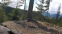
This 4km section of the Legacy Climb was machine built by Dream Wizards with funds from Forestry. You will find the large trees, shade and mellow grade a nice break from the previous sections of the Climbing Trail. This section follows an old railway bed from the first time this area was logged. You will pass under bothAngry Midget and Half Nelson. Next riders will then find themselves in selectively logged block that takes you up to Full Nelson look around for some amazing views across the Lava Flow. Beyond the Full Nelson junction the forest becomes tighter and the trail narrows and begins to twist more with lots of ups and downs. Climbers will enjoy the short punchy efforts needed to make it up clean.
Local Trail Association
-

-

-
Please consider joining or donating to the local trail association to supportdonate to earn trail karma!
trail development & maintenance.
Traditionally Indigenous Territory
More Stats for Climb Trail - Stl'lhalem Sintl' (mid) mountain bike trail trail
-
Altitude change729 ft
-
Altitude min1,268 ft
-
Altitude max1,998 ft
-
Altitude start1,268 ft
-
Altitude end1,998 ft
-
Grade5.3%
-
Grade max-36.3%
-
Grade min79.4%
-
Distance climb2 miles
-
Distance down2,589 ft
-
Distance flat1,138 ft
-
Avg time00:42:25
-
Avg reverse time00:46:23
- view trail stats
- Unknown
- Snow Groomed
- Snow Packed
- Snow Covered
- Snow Cover Inadequate
- Freeze/thaw Cycle
- Icy
- Prevalent Mud
- Wet
- Variable
- Ideal
- Dry
- Very Dry
The colour categories are based on what percentage of riders are riding a trail in its intended direction.
- > 96%
- > 90%
- > 80%
- > 70%
- > 50%
- < 50%
- bi-directional trail
- no data
- < 2 days
- < 1 week
- < 2 weeks
- < 1 month
- < 6 months
- > 6 months
- Downhill Only
- Downhill Primary
- Both Directions
- Uphill Primary
- Uphill Only
- One Direction
- Description
- Photos
- Description & Photos
- Videos
- most popular
- popular
- less popular
- not popular
- mountain biking recent
- mountain biking (>6 month)
- hiking (1 year)
- moto (1 year)
- Downhill Ski
- Backcountry Ski
- Nordic Ski
Save the current map location and zoom level as your default home location whenever this page is loaded.
SaveClimb Trail - ... Trail Reports
Recent Ridelog Activity on Trail
Past Week
- 65 rides
- 11 miles avg distance
6 Months
- 1,111 rides
- 11 miles avg distance
All
- 11,068 rides
Photos
Trail Lists
-
bms
28 trails
Routes with this trail
Trail Products
-
 SORCA Trail SupporterTrail Pass
-
+ 0
 maggiedurkin

Videos
![Riding Squamish - Part One [Ep#65]](https://ev1.pinkbike.org/tf/vt/1/yvt-24603-4.jpg)

Nearby Trails
- Parking Lot 1,375 ft
- Ring Creek Rip 1,375 ft
- Operation Panda Climb 1,775 ft
- Another Roadside Attraction 1,831 ft
- Lower Ditch Pig 2,060 ft
- embed Climb Trail - Stl'lhalem Sintl' (mid) trail on your website
- By canadaka
 Trailforks & contributors
 - #3075 - 14,962 views
- subscribe
- login to download gpx or kml files.