1,693 ft
Distance
-224 ft
Descent
00:03:59
Avg time
Supporters, Builders, Maintainers & Land Managers of Floppy Bunny Trail

Sombrio
since 2015Sponsor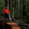
Patrick PodolskiBuilder
DiggerBuilder- past supporters

Cliff Bar
2014Sponsor
North Shore Bike Shop
2012 - 2013Sponsor
Floppy Bunny Details
-
Activities
- Mountain Bike
- E-Bike
- Hike
- Trail Running
-
Riding AreaMount Fromme
North Vancouver, British Columbia -
Difficulty Rating
-
Voted DifficultyBlue (16 votes)
-
Hiking SAC ScaleT1 Hiking
-
Trail TypeSingletrack
-
Bike TypeDH, AM
-
DirectionDownhill PrimaryPopular direction shown
-
Physical RatingModerate
-
Dogs AllowedYes
-
eBike AllowedYes up to Class 1
-
TTFs on TrailJump, Skinny
-
Ride in RainYes
-
Global Ranking
-
Local Popularity95 in Mountain Biking [+]
- 100 in E-Biking
- 50 in Trail Running
- 55 in Hiking
-
Land ManagerDistrict of North Vancouver
Short fast trail with optional jumps and drops. A few mandatory wooden trail features. The trail is great for new riders to sample what they might encounter higher up the mountain.
Access Info
Accessed off Mtn. Hwy two trails before the 2nd switchback. Exiting at the water tower/turnaround.
Local Trail Association
-

-

-
Please consider joining or donating to the local trail association to supportdonate to earn trail karma!
trail development & maintenance.
Traditionally Indigenous Territory
More Stats for Floppy Bunny mountain bike trail trail
-
Altitude change-224 ft
-
Altitude min1,168 ft
-
Altitude max1,391 ft
-
Altitude start1,391 ft
-
Altitude end1,168 ft
-
Grade-13.2%
-
Grade max-37.1%
-
Distance down1,604 ft
-
Distance flat89 ft
-
Avg time00:03:59
-
Avg reverse time00:11:20
- view trail stats
close
Trail Conditions
- Unknown
- Snow Groomed
- Snow Packed
- Snow Covered
- Snow Cover Inadequate
- Freeze/thaw Cycle
- Icy
- Prevalent Mud
- Wet
- Variable
- Ideal
- Dry
- Very Dry
Trail Flow (Ridden Direction)
Trailforks scans users ridelogs to determine the most popular direction each trail is ridden. A good flowing trail network will have most trails flowing in a single direction according to their intension.
The colour categories are based on what percentage of riders are riding a trail in its intended direction.
The colour categories are based on what percentage of riders are riding a trail in its intended direction.
- > 96%
- > 90%
- > 80%
- > 70%
- > 50%
- < 50%
- bi-directional trail
- no data
Trail Last Ridden
Trailforks scans ridelogs to determine the last time a trail was ridden.
- < 2 days
- < 1 week
- < 2 weeks
- < 1 month
- < 6 months
- > 6 months
Trail Ridden Direction
The intended direction a trail should be ridden.
- Downhill Only
- Downhill Primary
- Both Directions
- Uphill Primary
- Uphill Only
- One Direction
Contribute Details
Colors indicate trail is missing specified detail.
- Description
- Photos
- Description & Photos
- Videos
Trail Popularity ?
Trailforks scans ridelogs to determine which trails are ridden the most in the last 9 months.
Trails are compared with nearby trails in the same city region with a possible 25 colour shades.
Think of this as a heatmap, more rides = more kinetic energy = warmer colors.
- most popular
- popular
- less popular
- not popular
ATV/ORV/OHV Filter
Max Vehicle Width
inches
Radar Time
x
Activity Recordings
Trailforks users anonymized public ridelogs from the past 6 months.
- mountain biking recent
- mountain biking (>6 month)
- hiking (1 year)
- moto (1 year)
Activity Recordings
Trailforks users anonymized public skilogs from the past 12 months.
- Downhill Ski
- Backcountry Ski
- Nordic Ski
Jump Magnitude Heatmap
Heatmap of where riders jump on trails. Zoom in to see individual jumps, click circles to view jump details.
Trails Deemphasized
Trails are shown in grey.
Only show trails with NO bikes.
Save the current map location and zoom level as your default home location whenever this page is loaded.
Save
Directions to floppy-bunny trailhead
(49.359050, -123.040270)
update trails status or condition
Floppy Bunny Trail Reports
view all reports »
Recent Ridelog Activity on Trail
Past Week
- 61 rides
- 7 miles avg distance
6 Months
- 1,561 rides
- 7 miles avg distance
All
- 14,852 rides
Technical Trail Features (TTF)
- Bridge
 Bridge
 - Bridge Bridge
- Bridge / Optional Gap Jum Bridge
- Bridge Rolldown Bridge
- Dirt Box Bridge
- Entrance Roll-Down 1 Roller Coaster
- Entrance Roll-Down 2 Roller Coaster
- Ladder Bridge to Drop Drop
- Rainbow Bridge Bridge
- Rolldown Bridge Bridge
- Roller Coaster Roller Coaster
- Roller Coaster Roller Coaster
- Step Down Jump Jump
- Step Down Jump Jump
- Table Jump Jump
- Table Jump Jump
- Table Jump Jump
- Table Jump Jump
- Table Jump Jump
- Tabletop jump Jump
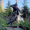
Photos
more »
Trail Lists
-
 NSMBA TAP 201319 trails
 -
 Favourite Trails8 trails
 -
Fromme Mountain
58 trails
-

-
 PHMB North Vancouver - Advanced Camps20 trails
 -
Lower Mount Fromme Progression Matrix
9 trails
-
Mount Fromme
22 trails
-
BC Trip
10 trails
-
Favourite MTB Trails
3 trails
Routes with this trail
more »
Trail Events
Trail Products
-
+ 0
Mcyeetus
(Sep 25, 2021 at 16:36)
Very light black, but good trail nonetheless. Good features to progress on. Good trail for people progressing from blue to blacks or a warmup.
[Reply]
Sterlingmarchand88
 (Apr 17, 2021 at 17:56)
I just started riding this week and did two runs on this today! I had to walk sections since I’m super new but loved that there were easier options for me to test out as a newer rider. Felt really accomplished when I rode out 85% of the trail and had a blast testing myself on it. Can’t wait to keep progressing my skills up there and learning to hit some of the higher trails
[Reply]
MichaelDavidKendrick
(Aug 15, 2020 at 15:13)
this trail is awesome. i love how it’s so accessible because you don’t have to climb to the top. and i also like how it’s beside bobsled. i like doing a couple laps of bobsled and floppy bunny
[Reply]
ranchitup
(Jul 22, 2020 at 22:30)
Awesome trail. Very similar in difficulty to Espresso. Comical that this is the same difficulty rating as Bookwus.
[Reply]
ship-it-fed-ex
Sometimes 1-2 features can make a trail rated the way it is. Realistically this should be a blue with black options. Waving on the side of caution and liability I think the black rating is just fine. Hope you like it.
[Reply]
JTJ10
(Apr 13, 2020 at 11:25)
Don't know if i would rate the trail blue as there are a few parts that are a little techy and steep(especially at the start if you are used to trails like bobsled) but for sure a fun entry level black thats a small taste of whats to come higher up the mountain. If you are a less experienced rider like I am getting into black diamond trails and trying to improve
or just wondering what a soft black trail looks like on fromme this trail is great, just make sure you know where the optional features are so you dont go down them accidentally.
All around an awesome trail perfect for building up skill level through optional and mandatory features that arnt too hard and are safe aswell as a great quick warm up run before the long climb!
[Reply]
or just wondering what a soft black trail looks like on fromme this trail is great, just make sure you know where the optional features are so you dont go down them accidentally.
All around an awesome trail perfect for building up skill level through optional and mandatory features that arnt too hard and are safe aswell as a great quick warm up run before the long climb!
HeinousShanous
(Apr 28, 2019 at 17:53)
Super fun trail, some relatively easy and fun jumps and drops, great way to warmup and have a bit of fun before the climb
[Reply]
desmondhowl
(Sep 25, 2017 at 10:18)
THis trail rules. As a newer rider it has some nice features that are helping me progress as a rider. I like that the small drops have clear landings. As i grow more comfortable I can try more difficult ones up the hill. Thanks to the builder.
[Reply]
ship-it-fed-ex
Glad you like it! Exactly why I built it like that! Keep the progression going!!
Pat
[Reply]
Pat
chris-mcintyre
(Sep 24, 2017 at 17:02)
Really fun, fast flow trails with lots of super fun drops and jumps! It would be awesome to have a jump/drop line once you get to the pedal section at the end but it’s great the way it is!
[Reply]
WilliamCornock
(Jul 28, 2017 at 18:52)
Just did this one for the first time to day and loved it. All the optionals are great as I'm not too experienced and am trying to improve my skills. Seems like a good trail for progression.
[Reply]
 Sharonb
The trail was originally called green tunnel, a fun fast loamy trail that was easy and fun. Continued use and rain made it the nasty chunder it was. Someone went in and built a bunch of ghetto stunts.
Pat has been working hard to put it back to the easy gentle trail it originally was.
Not quite as natural, but what do you expect after years or use and weather.
[Reply]
Pat has been working hard to put it back to the easy gentle trail it originally was.
Not quite as natural, but what do you expect after years or use and weather.
 rvass
(Sep 23, 2016 at 17:24)
rvass
(Sep 23, 2016 at 17:24)
There are so many gnarly trails. People put hard work into those trails. Dont complain just keep pedalling to grannie pipeline ladies oilcan. Gota be something for everyone. I like gnarly trails too. Thats why i go up higher but im not gona rip someone who put all that effort in. Go ride floppy for 1.5mins and go back up for the rest of your ride. No pleasing people on the shore anymore
[Reply]
 an3a
an3a
Guys, please stop throwing so much dirt at the trail. I loved the before last upgrade (new entrance), but the very last one was too much. Just flowy now, no more gnarl..
[Reply]
ship-it-fed-ex
Thanks for the positive feedback. I will be following my vision I've had for the trail, I've invested 5 years into this trail and I can't please everyone. We have plenty of harder trails up the mountain that are much rougher and have the experience you are looking for.
[Reply]
 CRich78
New entrance and drop are awesome! Looking forward to seeing what's in store for the old jumps.
[Reply]
Videos
more »


Nearby Trails
- Decommisioned Trail 427 ft
- Bobsled 518 ft
- Bobsled Spur 1,611 ft
- Warden's Climb 1,801 ft
- Parking Lot Access 1,844 ft
- embed Floppy Bunny trail on your website
- By canadaka Trailforks & contributors
- #3 - 53,605 views
- subscribe
- login to download gpx or kml files.