423 ft
Distance
4 ft
Climb
-13 ft
Descent
00:01:26
Avg time
Supporters, Builders, Maintainers & Land Managers of Upper John Deer Trail
- Knolly Bikes
since 2019Sponsor 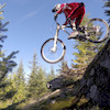
Martin Newman
since 2015Maintainer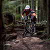
Penny Deck
since 2015Maintainer- past supporters

Norco John Henry Bikes
2016 - 2018Sponsor
Upper John Deer Details
-
Activities
- Mountain Bike
- Hike
- Trail Running
-
Riding AreaMount Seymour
North Vancouver, British Columbia -
AKAJohn Deere, Gone Fishing, Red Truck, JD
-
Difficulty Rating
-
Trail TypeSingletrack
-
Bike TypeDH, AM, XC
-
DirectionDownhill PrimaryPopular direction shown
-
Dogs AllowedYes
-
Global Ranking
-
Local Popularity100 in Mountain Biking [+]
- 65 in Trail Running
- 80 in Hiking
-
Land ManagerCMHC
A short flowy singletrack dropping down from Severed to Good Sir Martin
The trail is downhill only for mountain bikers. Do not ride uphill.
Access Info
Accessed from the top of main downhill section of Severed.
Local Trail Association
-
-

-
Please consider joining or donating to the local trail association to supportdonate to earn trail karma!
trail development & maintenance.
Traditionally Indigenous Territory
More Stats for Upper John Deer mountain bike trail trail
-
Altitude change-10 ft
-
Altitude min1,279 ft
-
Altitude max1,295 ft
-
Altitude start1,289 ft
-
Altitude end1,280 ft
-
Grade-2.4%
-
Grade max-13%
-
Grade min7.2%
-
Distance climb102 ft
-
Distance down167 ft
-
Distance flat151 ft
-
Avg time00:01:26
-
Avg reverse time00:07:22
- view trail stats
close
Trail Conditions
- Unknown
- Snow Groomed
- Snow Packed
- Snow Covered
- Snow Cover Inadequate
- Freeze/thaw Cycle
- Icy
- Prevalent Mud
- Wet
- Variable
- Ideal
- Dry
- Very Dry
Trail Flow (Ridden Direction)
Trailforks scans users ridelogs to determine the most popular direction each trail is ridden. A good flowing trail network will have most trails flowing in a single direction according to their intension.
The colour categories are based on what percentage of riders are riding a trail in its intended direction.
The colour categories are based on what percentage of riders are riding a trail in its intended direction.
- > 96%
- > 90%
- > 80%
- > 70%
- > 50%
- < 50%
- bi-directional trail
- no data
Trail Last Ridden
Trailforks scans ridelogs to determine the last time a trail was ridden.
- < 2 days
- < 1 week
- < 2 weeks
- < 1 month
- < 6 months
- > 6 months
Trail Ridden Direction
The intended direction a trail should be ridden.
- Downhill Only
- Downhill Primary
- Both Directions
- Uphill Primary
- Uphill Only
- One Direction
Contribute Details
Colors indicate trail is missing specified detail.
- Description
- Photos
- Description & Photos
- Videos
Trail Popularity ?
Trailforks scans ridelogs to determine which trails are ridden the most in the last 9 months.
Trails are compared with nearby trails in the same city region with a possible 25 colour shades.
Think of this as a heatmap, more rides = more kinetic energy = warmer colors.
- most popular
- popular
- less popular
- not popular
ATV/ORV/OHV Filter
Max Vehicle Width
inches
Radar Time
x
Activity Recordings
Trailforks users anonymized public ridelogs from the past 6 months.
- mountain biking recent
- mountain biking (>6 month)
- hiking (1 year)
- moto (1 year)
Activity Recordings
Trailforks users anonymized public skilogs from the past 12 months.
- Downhill Ski
- Backcountry Ski
- Nordic Ski
Jump Magnitude Heatmap
Heatmap of where riders jump on trails. Zoom in to see individual jumps, click circles to view jump details.
Trails Deemphasized
Trails are shown in grey.
Only show trails with NO bikes.
Save the current map location and zoom level as your default home location whenever this page is loaded.
Save
Directions to upper-john-deer trailhead
(49.335890, -122.981750)
update trails status or condition
Upper John Deer Trail Reports
view all reports »
Recent Ridelog Activity on Trail
Past Week
- 100 rides
- 8 miles avg distance
6 Months
- 3,075 rides
- 8 miles avg distance
All
- 24,754 rides
Photos
more »
Trail Lists
-
 CMHC Trails35 trails
 -
Mount Seymour
57 trails
Routes with this trail
more »
Trail Products
Videos
more »

20:39 |
64 |
Nov 12, 2021 , North Vancouver

3:57 |
121 |
Aug 9, 2021 , North Vancouver

16:04 |
91 |
Jun 25, 2021 , North Vancouver

7:51 |
180 |
Dec 16, 2020 , North Vancouver
Nearby Trails
- Deer John 79 ft
- Asian Adonis 259 ft
- John Deer 584 ft
- C-buster 1,437 ft
- Baden Adonis Connector 1,594 ft
- embed Upper John Deer trail on your website
- By mtbmudhoney
 NSMBA SHORE CORPS FVMBA - ADMIN & contributors
 - #46518 - 12,300 views
- subscribe
- login to download gpx or kml files.