1,178 ft
Distance
-195 ft
Descent
00:03:24
Avg time
Supporters, Builders, Maintainers & Land Managers of Corkscrew Trail

CRSP Chartered Professional Accountants
since 2022Sponsor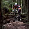
Penny DeckMaintainer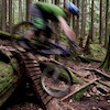
Dave Clendenan
since 2018Maintainer- past supporters

McNeney McNeney Lawyers
2018 - 2020Sponsor
Okanagan Spring Brewery
2014 - 2017Sponsor
Bank of Montreal
2011 - 2013Sponsor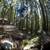
Mark WoodMaintainer
Corkscrew Details
-
Activities
- Mountain Bike
- Hike
- Trail Running
-
Riding AreaMount Seymour
North Vancouver, British Columbia -
Difficulty Rating
-
Voted DifficultyBlack Diamond (2 votes)
-
Hiking SAC ScaleT1 Hiking
-
Trail TypeSingletrack
-
Bike TypeDH
-
DirectionDownhill OnlyPopular direction shown
-
Dogs AllowedYes
-
TTFs on TrailA-Frame, Bridge, Drop
-
Ride in RainYes
-
Global Ranking
-
Local Popularity100 in Mountain Biking [+]
- 50 in Trail Running
- 70 in Hiking
-
Land ManagerMetro Vancouver
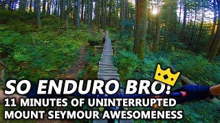
A North Shore classic. Many of the optional skinnies have rotted away or been removed by Metro Vancouver.
Technical with plenty of roots and rocks and some optional woodwork.
Connect to Salvation for more woodwork and skinnies or continue to merge with Incline and exit via Power Line
Access Info
Easily accessed from the road, by riding up the road or parking at the "Vancouver Picnic Area" parking lot. Can also pedal up Mushroom Trail to access where it intersects with Incline.
Local Trail Association
-
-

-
Please consider joining or donating to the local trail association to supportdonate to earn trail karma!
trail development & maintenance.
Traditionally Indigenous Territory
More Stats for Corkscrew mountain bike trail trail
-
Altitude change-195 ft
-
Altitude min1,628 ft
-
Altitude max1,823 ft
-
Altitude start1,823 ft
-
Altitude end1,627 ft
-
Grade-16.5%
-
Grade max-33%
-
Grade min-4%
-
Distance down1,178 ft
-
Avg time00:03:24
-
Avg reverse time00:05:29
- view trail stats
close
Trail Conditions
- Unknown
- Snow Groomed
- Snow Packed
- Snow Covered
- Snow Cover Inadequate
- Freeze/thaw Cycle
- Icy
- Prevalent Mud
- Wet
- Variable
- Ideal
- Dry
- Very Dry
Trail Flow (Ridden Direction)
Trailforks scans users ridelogs to determine the most popular direction each trail is ridden. A good flowing trail network will have most trails flowing in a single direction according to their intension.
The colour categories are based on what percentage of riders are riding a trail in its intended direction.
The colour categories are based on what percentage of riders are riding a trail in its intended direction.
- > 96%
- > 90%
- > 80%
- > 70%
- > 50%
- < 50%
- bi-directional trail
- no data
Trail Last Ridden
Trailforks scans ridelogs to determine the last time a trail was ridden.
- < 2 days
- < 1 week
- < 2 weeks
- < 1 month
- < 6 months
- > 6 months
Trail Ridden Direction
The intended direction a trail should be ridden.
- Downhill Only
- Downhill Primary
- Both Directions
- Uphill Primary
- Uphill Only
- One Direction
Contribute Details
Colors indicate trail is missing specified detail.
- Description
- Photos
- Description & Photos
- Videos
Trail Popularity ?
Trailforks scans ridelogs to determine which trails are ridden the most in the last 9 months.
Trails are compared with nearby trails in the same city region with a possible 25 colour shades.
Think of this as a heatmap, more rides = more kinetic energy = warmer colors.
- most popular
- popular
- less popular
- not popular
ATV/ORV/OHV Filter
Max Vehicle Width
inches
Radar Time
x
Activity Recordings
Trailforks users anonymized public ridelogs from the past 6 months.
- mountain biking recent
- mountain biking (>6 month)
- hiking (1 year)
- moto (1 year)
Activity Recordings
Trailforks users anonymized public skilogs from the past 12 months.
- Downhill Ski
- Backcountry Ski
- Nordic Ski
Jump Magnitude Heatmap
Heatmap of where riders jump on trails. Zoom in to see individual jumps, click circles to view jump details.
Trails Deemphasized
Trails are shown in grey.
Only show trails with NO bikes.
Save the current map location and zoom level as your default home location whenever this page is loaded.
Save
Directions to corkscrew trailhead
(49.343160, -122.973700)
update trails status or condition
Corkscrew Trail Reports
view all reports »
Recent Ridelog Activity on Trail
Past Week
- 91 rides
- 8 miles avg distance
6 Months
- 2,484 rides
- 9 miles avg distance
All
- 18,189 rides
Technical Trail Features (TTF)
- Corkscrew 1 - Entry skinn
 Skinny
 - Corkscrew 10 - ladder ram A-Frame
- Corkscrew 2 - Skinny plan Skinny
- Corkscrew 3 - Rock roll w Ladder Bridge
- Corkscrew 4 - Ladder brid Ladder Bridge
- Corkscrew 5 - Optional dr Drop
- Corkscrew 6 - Rollercoast Ladder Bridge
- Corkscrew 7 - Bridge on r Bridge
- Corkscrew 8 - Up and over A-Frame
- Corkscrew 9 - Bridge over Bridge
Photos
more »
Trail Lists
-
 CMHC Trails35 trails
 -
Mount Seymour
57 trails
-
LSCR
47 trails
-
Seymour
6 trails
-
MOUNT SEYMOUR
7 trails
Routes with this trail
more »
Trail Products
Links
-
+ 0
 Mattc00
Trail in great shape. Really enjoyable.
[Reply]
Mcyeetus
(Oct 2, 2021 at 21:52)
One of the best trails on seymour, flowy tech trail to have a ton of fun on! After corkscrew, make sure to go down powerline for a pump track!
[Reply]
bboyshredder
(Aug 28, 2019 at 17:56)
this trail is awesome its got a mix of tech , skinnys ,flow. and after don't ride the incline exit , ride the power line trail its a downhill pump track.
[Reply]
Videos
more »


Nearby Trails
- Incline 0 ft
- Mushroom Trail 794 ft
- Mushroom Connector 1,152 ft
- Salvation 1,198 ft
- Ned's Atomic Dustbin 1,342 ft
- embed Corkscrew trail on your website
- By canadaka
 Trailforks & contributors
 - #204 - 20,452 views
- subscribe
- login to download gpx or kml files.