3,901 ft
Distance
-518 ft
Descent
00:15:12
Avg time
Supporters, Builders, Maintainers & Land Managers of Pangor Trail

Giant Vancouver
since 2016Sponsor- Sven Luebke
since 2011Builder 
Penny DeckBuilder- past supporters

Acklands-Grainger
2015 - 2016Sponsor
Muddbunnies
2011 - 2014Sponsor
Ryders Eyewear
2011 - 2014Sponsor
Pangor Details
-
Activities
- Mountain Bike
- Hike
- Trail Running
-
Riding AreaMount Seymour
North Vancouver, British Columbia -
AKATeam Pangor
-
Difficulty Rating
-
Voted DifficultyBlack Diamond (3 votes)
-
Trail TypeSingletrack
-
Bike TypeDH, AM
-
DirectionDownhill OnlyPopular direction shown
-
Physical RatingModerate
-
SeasonYear round
-
Dogs AllowedYes
-
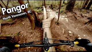
TTFs on TrailDrop, Rock Face, Skinny
-
Ride in RainYes
-
Global Ranking
-
Local Popularity95 in Mountain Biking [+]
- 60 in Trail Running
- 85 in Hiking
-
Land ManagerDistrict of North Vancouver
Pangor also known as Team Pangor is a very popular trail filled with optional skinnies, drops and natural TTFs with ride arounds. While considered an intermediate trail it contains many difficult features. Pangor has seen a lot of love since 2011 with 48+ trail days, thanks to TAP and Builders Academy supporters.
Access Info
Accessed from the Baden Powell, Pangor is most commonly done after Pingu.
Local Trail Association
-

-

-
Please consider joining or donating to the local trail association to supportdonate to earn trail karma!
trail development & maintenance.
Traditionally Indigenous Territory
More Stats for Pangor mountain bike trail trail
-
Altitude change-518 ft
-
Altitude min828 ft
-
Altitude max1,345 ft
-
Altitude start1,345 ft
-
Altitude end827 ft
-
Grade-13.3%
-
Grade max-27.9%
-
Distance down3,763 ft
-
Distance flat138 ft
-
Avg time00:15:12
-
Avg reverse time00:10:58
- view trail stats
close
Trail Conditions
- Unknown
- Snow Groomed
- Snow Packed
- Snow Covered
- Snow Cover Inadequate
- Freeze/thaw Cycle
- Icy
- Prevalent Mud
- Wet
- Variable
- Ideal
- Dry
- Very Dry
Trail Flow (Ridden Direction)
Trailforks scans users ridelogs to determine the most popular direction each trail is ridden. A good flowing trail network will have most trails flowing in a single direction according to their intension.
The colour categories are based on what percentage of riders are riding a trail in its intended direction.
The colour categories are based on what percentage of riders are riding a trail in its intended direction.
- > 96%
- > 90%
- > 80%
- > 70%
- > 50%
- < 50%
- bi-directional trail
- no data
Trail Last Ridden
Trailforks scans ridelogs to determine the last time a trail was ridden.
- < 2 days
- < 1 week
- < 2 weeks
- < 1 month
- < 6 months
- > 6 months
Trail Ridden Direction
The intended direction a trail should be ridden.
- Downhill Only
- Downhill Primary
- Both Directions
- Uphill Primary
- Uphill Only
- One Direction
Contribute Details
Colors indicate trail is missing specified detail.
- Description
- Photos
- Description & Photos
- Videos
Trail Popularity ?
Trailforks scans ridelogs to determine which trails are ridden the most in the last 9 months.
Trails are compared with nearby trails in the same city region with a possible 25 colour shades.
Think of this as a heatmap, more rides = more kinetic energy = warmer colors.
- most popular
- popular
- less popular
- not popular
ATV/ORV/OHV Filter
Max Vehicle Width
inches
Radar Time
x
Activity Recordings
Trailforks users anonymized public ridelogs from the past 6 months.
- mountain biking recent
- mountain biking (>6 month)
- hiking (1 year)
- moto (1 year)
Activity Recordings
Trailforks users anonymized public skilogs from the past 12 months.
- Downhill Ski
- Backcountry Ski
- Nordic Ski
Jump Magnitude Heatmap
Heatmap of where riders jump on trails. Zoom in to see individual jumps, click circles to view jump details.
Trails Deemphasized
Trails are shown in grey.
Only show trails with NO bikes.
Save the current map location and zoom level as your default home location whenever this page is loaded.
Save
Directions to pangor trailhead
(49.336730, -122.973560)
update trails status or condition
Pangor Trail Reports
view all reports »
Recent Ridelog Activity on Trail
Past Week
- 54 rides
- 7 miles avg distance
6 Months
- 1,674 rides
- 8 miles avg distance
All
- 13,804 rides
Photos
more »
Trail Lists
-
 NSMBA TAP 201319 trails
 -
 CMHC Trails35 trails
 -
Mount Seymour
57 trails
-
MOUNT SEYMOUR
7 trails
Routes with this trail
more »
Trail Products
Links
-
+ 0
 Mattc00
Trail in great condition. Really great day out.
[Reply]
 wrongcrowd
Heyo, looking for a bunch of guys I rode Pangor with on Nov 26 2021. I think I gave y'all the wrong phone number somehow. Reach out if any of you see this! (This is Cam)
[Reply]
 leelau
Still a classic. Thanks for the trailwork Sven. Especially nice touch keeping the janky skinnies still in play
[Reply]
 heckler73
Thanks, but I can't take the credit. Maintaining the old structures was all NSMBA trailcrew work this past summer!
[Reply]
leelau
Well then props to whoever OKed and directed the woodwork rebuild. And if I recall Muddbunnies helped back in the day so tip of the hat to them.
And going back in time thanks to Dave Wicks Chris Z, and the original Team Pangor for the cool line
[Reply]
And going back in time thanks to Dave Wicks Chris Z, and the original Team Pangor for the cool line
Videos
more »


Nearby Trails
- Boogieman 492 ft
- Lower Incline 1,506 ft
- Power Line 1,768 ft
- Pingu 1,998 ft
- Upper Severed 2,536 ft
- embed Pangor trail on your website
- By canadaka
 Trailforks & contributors
 - #75 - 29,818 views
- subscribe
- login to download gpx or kml files.