Supporters, Builders, Maintainers & Land Managers of Severed D Trail

Bicicletta West Vancouver
since 2018Sponsor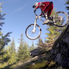
Martin Newman
since 2013Builder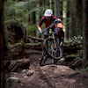
Penny Deck
since 2013Builder- past supporters

NSRide
2014 - 2017Sponsor
Different Bikes
2014 - 2017Sponsor
Severed D Details
-
Activities
- Mountain Bike
- Hike
- Trail Running
-
Riding AreaMount Seymour
North Vancouver, British Columbia -
AKAGood Samaritan
-
Difficulty Rating
-
Voted DifficultyBlack Diamond (1 vote)
-
Trail TypeSingletrack
-
Bike TypeDH, AM
-
DirectionDownhill OnlyPopular direction shown
-
Physical RatingHard
-
SeasonYear round
-
Dogs AllowedYes
-
TTFs on TrailBridge, Drop, Rock Face, Skinny
-
Ride in RainYes
-
Global Ranking
-
Local Popularity90 in Mountain Biking [+]
- 75 in Trail Running
- 50 in Hiking
-
Land Manager
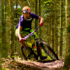
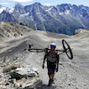
One of the oldest trails on the mountain with a major overhaul in 2013/2014 still retains its technical nature with a little more flow. Used to access C Buster and John Deer, the trail starts with a steep and stepped chute and rock roll (this section can be bypassed via the new “Dickie” alternate), a flattish pumpy section then takes riders to the main descent just after the John Deer trail head. The trail gets steeper as it approaches the Good Sir Martin intersection then steeper still just after before it’s final flowy section to the exit onto Bridle Path. The trail includes a few skinnies all low to the ground, and several small rock rolls, some of which may be dropped, and a few wider ladder bridges.
The trail is popular with hikers and runners alike and mountain bikers should be prepared to expect foot traffic on the trail. The trail is downhill only for mountain bikers. Do not ride uphill.
Access Info
The trailhead is accessed either from the Baden Powell or via the Upper Severed from the powerlines. Severed ends at Bridle Path.
Local Trail Association
-
-

-
Please consider joining or donating to the local trail association to supportdonate to earn trail karma!
trail development & maintenance.
Traditionally Indigenous Territory
More Stats for Severed D bike trail trail
-
Altitude change-650 ft
-
Altitude min743 ft
-
Altitude max1,393 ft
-
Altitude start1,393 ft
-
Altitude end745 ft
-
Grade-15.2%
-
Grade max-60%
-
Grade min-1.2%
-
Distance down4,245 ft
-
Distance flat23 ft
-
Avg time00:11:06
-
Avg reverse time00:16:43
- view trail stats
- Unknown
- Snow Groomed
- Snow Packed
- Snow Covered
- Snow Cover Inadequate
- Freeze/thaw Cycle
- Icy
- Prevalent Mud
- Wet
- Variable
- Ideal
- Dry
- Very Dry
The colour categories are based on what percentage of riders are riding a trail in its intended direction.
- > 96%
- > 90%
- > 80%
- > 70%
- > 50%
- < 50%
- bi-directional trail
- no data
- < 2 days
- < 1 week
- < 2 weeks
- < 1 month
- < 6 months
- > 6 months
- Downhill Only
- Downhill Primary
- Both Directions
- Uphill Primary
- Uphill Only
- One Direction
- Description
- Photos
- Description & Photos
- Videos
- most popular
- popular
- less popular
- not popular
- mountain biking recent
- mountain biking (>6 month)
- hiking (1 year)
- moto (1 year)
- Downhill Ski
- Backcountry Ski
- Nordic Ski
Save the current map location and zoom level as your default home location whenever this page is loaded.
SaveSevered D Trail Reports
Recent Ridelog Activity on Trail
Past Week
- 35 rides
- 8 miles avg distance
6 Months
- 1,040 rides
- 8 miles avg distance
All
- 9,290 rides
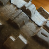
Technical Trail Features (TTF)
- Bridge
 Bridge
 - Bridge Bridge
- Bridge Bridge
- Bridge Bridge
- Cedar plank skinny Skinny
- Cedar plank skinny Skinny
- Cedar plank skinny Skinny
- Cedar plank skinny Skinny
- Ground level ladder bridg Ladder Bridge
- Short wood ramp Skinny
- Skinny Skinny
- The Hurdie Gurdie - woode Roller Coaster
Photos
Trail Lists
-
 CMHC Trails35 trails
 -
Mount Seymour
57 trails
-
MOUNT SEYMOUR
7 trails
-
BC Trip
10 trails
Routes with this trail
Trail Products
-
- 2
 Nonsmoker
(Mar 28, 2021 at 16:28)
Nonsmoker
(Mar 28, 2021 at 16:28)
GO « F » yourself!!! The only reason I said nothing to him today was because my son was with me. I love this trail and I also volunteered on it few years back. But remember riders, it’s not only for us bikers, hikers are allowed also.
Cheers
 r0bb
r0bb
 Urbanprophecy
 flotob
Cheers
Topeak, golden in a black sleeve.
 ehfour
Videos


Nearby Trails
- Lower Incline 2,448 ft
- Forever After - Baden Powell Connector 2,477 ft
- Mushroom Trail 3,022 ft
- Mushroom Connector 3,202 ft
- Baden Powell (bikeable) 1 mile
- embed Severed D trail on your website
- By canadaka
 Trailforks & contributors
 - #250 - 33,488 views
- subscribe
- login to download gpx or kml files.