4.3 miles
Distance
1,099 ft
Climb
-1,097 ft
Descent
1,586 ft
High Point
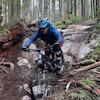
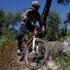
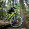
A relatively new school flowy ride with a mix of single track climbing with some technical features and a top climbing section of double-track. The descent is a perfect mix of new school and old school shore riding. Expect a sustained descent of up to 45+ minutes.
Detailed Description
Dales, Forever After, High School - Intermediate/Advanced Mountain Bike Route is a 4 mile popular intermediate route located near North Vancouver British Columbia. This mountain bike only route can be used one direction and has a hard overall physical rating. This route includes 22 trails. This route climbs 1,099 ft with a max elevation of 1,586 ft then descends -1,097 ft.
Links
Local Trail Association
Please consider joining or donating to the local riding association to support trail development & maintenance.
donate to earn trail karma!
Trail Products
-
+ 0
 subieoutlaw
Trail High School League
Fun fun fun. Smooth and fast XC trail.
[Reply]
subieoutlaw
Trail High School League
Fun fun fun. Smooth and fast XC trail.
[Reply]
 liamdubs
Trail Baden Powell (Bikeable)
The direction is basically wrong. It is 100% unrideable from forever after to severed upwards, but is a spicy treat downwards.
[Reply]
liamdubs
Trail R & R Climb
This trail actually rules, great techy uphill challenge.
[Reply]
 conrad-hoc
Trail High School League
great trail. fun to learn on. I like that its a loop
[Reply]
conrad-hoc
Trail High School League
great trail. fun to learn on. I like that its a loop
[Reply]
adnauseam
 (Oct 8, 2021 at 15:37)
Trail Applicator
Difficult to find. The trailhead sign is facing the wrong direction for those looking for it on the way down. The mapb doesn't show it but the first bit is a moderately technical climb peaking at a large rock. Pretty chunky going down for a few sections all in a row. A harder black trail.
[Reply]
Mcyeetus
(Oct 2, 2021 at 21:48)
Trail Bridle Path
Fun xc trail/connector trail with some fun optional features to have fun on!
[Reply]
Mcyeetus
(Oct 2, 2021 at 21:48)
Trail Bridle Path
Fun xc trail/connector trail with some fun optional features to have fun on!
[Reply]
cannae
(Sep 28, 2021 at 10:45)
Trail Applicator
I would love to ride this trail but it seems impossible to find
[Reply]
Kazuaki
(Aug 19, 2021 at 18:33)
Trail Forever After
I’d rate it a dark blue on the downhill parts. And full black on the uphill parts. I gotta get better at climbing!
[Reply]
liamdubs
Trail Shorn Scrotum
It's like a chicken line to the right just before severed D gets steeper for a bit - but it takes you out onto penny lane. If you want to resume severed D, climb up Penny lane again and resume.
[Reply]
liamdubs
Trail Good Sir Martin
Please make sure to ring the bell at the intersection of John Deer and Good Sir Martin. If you don't ring the bell your strava/trailforks ride will NOT record this trail. It's real important to ring the bell.
[Reply]
liamdubs
Trail Applicator
Folks who rated this trail low don’t appreciate the good things in life. A short trail thats easy to session , features steep rocks and roots. Its a bundle of fun, probably treacherous in the wet. The entrance is hard to find, but its a steep technical climb from the the bottom of pussyfoot where a bunch of trails intersect.
[Reply]
corerider
(Nov 7, 2021 at 8:18)
Trail Applicator
This trail actually is one of my favourites on Seymour. I mostly push UP it to do it. Short but well worth it.
[Reply]
 kyleluvsdh
Trail Forever After
We should really adopt the New Zealand trail grading system in Canada. It bridges the gap nicely between between 'hard blue's' and 'easy black's'. Windrock Bike Park, TN. Adopted the NZ grading system in the past year as well. It makes sense. Here's what it would look like:
NZ Trail Grading System:
Grade 1 - White (Easiest)
Grade 2 - Green (Easy)
Grade 3 - Blue (Intermediate)
Grade 4 - Dark Blue (Advanced)
Grade 5 - Black (Expert)
Grade 6 - Double Black (Extreme)
Grade 7 - Pro Line (Extremely Dangerous)
[Reply]
NZ Trail Grading System:
Grade 1 - White (Easiest)
Grade 2 - Green (Easy)
Grade 3 - Blue (Intermediate)
Grade 4 - Dark Blue (Advanced)
Grade 5 - Black (Expert)
Grade 6 - Double Black (Extreme)
Grade 7 - Pro Line (Extremely Dangerous)
MintyTingles
(Dec 3, 2020 at 19:29)
Trail Dale's Trail
Two trees still down and blocking the trail at the 7th turn.
[Reply]
Hanooshka
(Dec 1, 2020 at 10:07)
Trail Dale's Trail
Trees down across the trail near the top of the trail.
[Reply]

 pinker001
Trail Good Sir Martin
Challenging and enjoyable. The trail is pretty steep in some sections with tight switchbacks at steep grade with some rocks to traverse coming through the switchbacks. Physically and technically challenging. I find myself clipping rocks with my pedals and have yet to ride the whole thing without putting a foot down, but I’ll keep trying.
[Reply]
Dukechillington
(Jun 29, 2020 at 22:48)
Trail Forever After
Awesome trail! Less busy then other areas and super fun on an e-bike with it’s XC flow. Rode on a wet day after almost dying on Dales (no, seriously!) thinking Forever After would be more of the same but was pleasantly surprised!
[Reply]
 0ut5ide
Trail Forever After
Nice conditions today. Good grip on the rocks. Just a few puddles.
[Reply]
bboyshredder
(Sep 14, 2019 at 17:10)
Trail Applicator
Awesome trail hard to find it, but its sooooooooooo fun because its a dirt slide with two rock drops.
[Reply]
abueckert
(Sep 8, 2019 at 18:12)
Trail Dale's Trail
September 8, 2019. Suspicious behaviour somewhere around the TTF cedar plank skinny. Some guy 20 ft off the trail to the right digging a hole with a shovel behind a fallen log. Had a black dog and bright yellow rain gear. Definitely not trail crew. Seemed very strange. Not trail crew, wasn't anywhere near a trail. Heads up.
[Reply]
jjanetka
(Aug 30, 2019 at 20:24)
Trail Dale's Trail
Another good Seymour ride. Connects well with Forever and HSL if your goal is to make it to Hiyanas or Riverside Dr.
[Reply]
jjanetka
(Aug 30, 2019 at 20:21)
Trail Forever After
Great trail. Nice ride from 2nd switchback parking lot from Corkscrew to Mushroom to Dales to Forever. Yes, probably deserves the black - a few spots are a little tricky if you are going slower (I'm sure the faster just float over this rough stuff). Not a flashy trail but still a good ride.
[Reply]
bboyshredder
(Aug 28, 2019 at 17:50)
Trail Good Sir Martin
I love this trail . if you hate climbing stick to the old buck because its way shorter. but its awesome and smooth but penny lane isn't witch is before good sir Martin. not good for bigginer climbers .
[Reply]
Mike1001
(Aug 14, 2019 at 21:33)
Trail Baden Powell (Bikeable)
This is basically a hike a bike trail for at least half of it.... the bikeable part is just a boring connector to other bikeable trails
[Reply]
 bucky99
Trail Dale's Trail
Watch out for ebikes riding up trail. Apparently rules don't apply to them.
[Reply]
 xTwoSnakesx
Trail Applicator
Cool trail, but confusing for many reasons:
1. the map makes a short section of this trail part of the climbing route, which seems odd
2. there is an old fall line trail that follows the RR climber that has a tree at the top with a tiny sign that says "Applicator" in marker but seems to point in the opposite direction
3. there is no signage for the actual Applicator turnoff?
[Reply]
1. the map makes a short section of this trail part of the climbing route, which seems odd
2. there is an old fall line trail that follows the RR climber that has a tree at the top with a tiny sign that says "Applicator" in marker but seems to point in the opposite direction
3. there is no signage for the actual Applicator turnoff?

Markpervan
(Jun 12, 2019 at 22:32)
Trail Dale's Trail
Awesome trail. Love the work done. Nice flow great tec. I rode this trail for the first time yesterday. I bailed hard at the monster rock feature. Broke 3 ribs! No explanation just a bad day. I'll be back to send it soon I hope. Ride safe everyone.
[Reply]
 ataraxie
Trail Forever After
Forever After is my favorite trail on Seymour! I like how it's mostly downhill with a few XC sections in between. It makes it seem a loong ride! I think it deserves the black rating. It's harder than other black ones like Corkskrew in my opinion.
[Reply]
javabk
(Jun 4, 2019 at 20:52)
Trail Baden Powell (Bikeable)
This is mostly hike a bike trail
[Reply]
 ryancartiers
Trail Bridle Path
Had some good rides. Probably easier with a full suspension bike.
[Reply]
ryancartiers
Trail Bridle Path
Had some good rides. Probably easier with a full suspension bike.
[Reply]
 MKBERGEY1
(Mar 30, 2019 at 17:27)
MKBERGEY1
(Mar 30, 2019 at 17:27)
Trail Good Sir Martin
Ride well and Sheeeessssss nice!! ????????
[Reply]
 jalee
(Mar 13, 2019 at 23:21)
jalee
(Mar 13, 2019 at 23:21)
Trail Forever After
Such a good trail. Has the most diversity of the trails I routinely ride on the shore. Mixed technical XC and all mountain. It’s a blast through beautiful forest. I would say a must ride after Dale’s, in addition to Pangor my other favourite on Seymour
[Reply]
crashelman
(Sep 14, 2018 at 11:30)
Trail Dale's Trail
What a lot of digging for the new upper flow section!! Transitions into more typical shore
[Reply]
crashelman
(Sep 14, 2018 at 11:29)
Trail Good Sir Martin
Nice technical climbing alternative
[Reply]
 rskibobirney
(Jul 15, 2018 at 18:57)
rskibobirney
(Jul 15, 2018 at 18:57)
Trail High School League
Ridiculously good fun, well-maintained trail. Starting with a couple of banked turns, you’re thrown into fast rolling trail with a couple of small drops. Suitable for newbies (like me) and I’m sure would still be fun for experienced riders.
[Reply]
 KevinStafford
(Jul 8, 2018 at 14:37)
KevinStafford
(Jul 8, 2018 at 14:37)
Trail Applicator
Though short, this little trail is every bit as fun as Severed D
[Reply]

 rovadon
Trail Shorn Scrotum
Tree across trail halfway down at xx) face
[Reply]
 Shokunin
(Sep 11, 2017 at 20:06)
Shokunin
(Sep 11, 2017 at 20:06)
Trail Forever After
I'm new to the shore, but this trail was so hard for a blue. Even compared to some other blues in the area.
[Reply]
paulbc
(Sep 11, 2017 at 20:26)
Trail Forever After
You're not the only one who thinks that. Last summer, there was a piece of tape on the entrance sign, right under the word "Harder", that said "...than any other blue trail". Call it navy blue.
[Reply]
Shokunin
(Sep 13, 2017 at 20:07)
Trail Forever After
Good to know I'm not the only one  The trail looks a lot more mellow in that video from 2014 too.
[Reply]
WilliamCornock
(Mar 4, 2018 at 14:33)
Trail Forever After
Was just up there yesterday and it had a black diamond on the sign. They must have changed it quite recently.
[Reply]
 DMal
DMal
Trail Penny Lane
Possibly my favourite section of the Seymour climb. The corners are open enough that you can get some good uphill flow going. And it takes you right to the rowdy part of Severed, perfect for tacking a little bit more onto the end of a ride.
[Reply]
DMal
Trail Penny Lane
Possibly my favourite section of the Seymour climb. The corners are open enough that you can get some good uphill flow going. And it takes you right to the rowdy part of Severed, perfect for tacking a little bit more onto the end of a ride.
[Reply]
 meloroast
Trail Good Sir Martin
this trail rides like a dream. absolutely love it! great work!!
[Reply]
DMal
Trail Upper Dale's Trail
I saw 2 guys climbing this trail on a busy Sunday morning. Climbing this trail, especially at busy times, is very dangerous. People coming down are going fast and don't expect climbers.
[Reply]
 CRich78
Trail Good Sir Martin
Phenomenal climbing trail. Thanks for all the beautiful work Martin and Penny. Rode GSM for the first time today and enjoyed every inch of it. It's so great to be able to loop back to Baden without having to head over to Old Buck or Hyannis. Awesome. I'll definitely be heading up to ride some Seymour loops more often. Thanks again!
[Reply]
 bikejunky
Trail Good Sir Martin
Stung. Twice. Ouch. Great trail nonetheless.
[Reply]
DMal
Trail Good Sir Martin
Great climbing trail. It climbs through a beautiful part of the forest, and the grade is nice and moderate.
[Reply]
moballa
(Jul 12, 2015 at 21:01)
Trail Good Sir Martin
My son and I rode Good Sir this morning which allowed us to do a couple of laps up there which doesn't happen often for us. The trail meanders beautifully through pristine forest and feels like it's been there forever - a testament to the fantastic engineering and careful planning that went into this right down to the precise fern transplanting! "Isn't this awesome!" was echoed by many of the other excited riders we encountered along the trail today. Congratulations Martin and Penny and to all the other volunteers! Good Sir Martin will be one of the most enjoyed trails on the north shore.
[Reply]
 frenchfriedfun
Trail Good Sir Martin
the Christmas corner is sick ! and the bunch after that too..
sick trail
[Reply]
sick trail

 trevmillion
(Aug 29, 2014 at 17:35)
trevmillion
(Aug 29, 2014 at 17:35)
Trail High School League
very fun XC trail. Minimal roots, some small drops and a lot of rolling terrain. Well maintained
[Reply]
trevmillion
(Aug 29, 2014 at 17:35)
Trail High School League
very fun XC trail. Minimal roots, some small drops and a lot of rolling terrain. Well maintained
[Reply]
 canadaka
Trail Baden Powell (Bikeable)
This section gps'ed on Seymour is mostly all rideable. The section from "Old Buck" to the Powerlines was upgraded last winter for an easier climb and is used a lot.
The descent portion from the powerlines to the "BP to Powerline Connector" was upgraded for the BC Bike Race. The trail after this point is not rideable, it gets very steep with steps. Once it hits "Bridle Path" its rideable again.
[Reply]
The descent portion from the powerlines to the "BP to Powerline Connector" was upgraded for the BC Bike Race. The trail after this point is not rideable, it gets very steep with steps. Once it hits "Bridle Path" its rideable again.
trevmillion
(Aug 28, 2014 at 12:17)
Trail Baden Powell (Bikeable)
how much of this trail can you ride bike on?
[Reply]
Trails in Route
| 1,010 ft | |||||
| 571 ft | |||||
| 906 ft | |||||
| 1,824 ft | |||||
| 712 ft | |||||
| 249 ft | |||||
| 443 ft | |||||
| 7 ft | |||||
| 328 ft | |||||
| 679 ft | |||||
| 4,603 ft | |||||
| 404 ft | |||||
| 1,558 ft | |||||
| 118 ft | |||||
| 699 ft | |||||
| 144 ft | |||||
| 2,211 ft | |||||
| 4,449 ft | |||||
| 16 ft | |||||
| 1,047 ft | |||||
| 456 ft | |||||
| 400 ft |
Details
-
Riding area
-
Primary ActivityMountain Bike
-
Difficulty ratingBlue
-
Route TypeLoop
-
DirectionOne Direction
-
Physical ratingHard
-
Ridelogs
More Stats for Dales, Forever After, High School - Intermediate/Advanced Mountain Bike Route mountain bike route
-
Altitude min521 ft
-
Altitude start521 ft
-
Altitude end522 ft
-
Grade max-55.3%
-
Grade min36.7%
-
Distance climb2 miles
-
Distance down2 miles
-
Distance flat2,631 ft
close
Trail Conditions
- Unknown
- Snow Groomed
- Snow Packed
- Snow Covered
- Snow Cover Inadequate
- Freeze/thaw Cycle
- Icy
- Prevalent Mud
- Wet
- Variable
- Ideal
- Dry
- Very Dry
Trail Flow (Ridden Direction)
Trailforks scans users ridelogs to determine the most popular direction each trail is ridden. A good flowing trail network will have most trails flowing in a single direction according to their intension.
The colour categories are based on what percentage of riders are riding a trail in its intended direction.
The colour categories are based on what percentage of riders are riding a trail in its intended direction.
- > 96%
- > 90%
- > 80%
- > 70%
- > 50%
- < 50%
- bi-directional trail
- no data
Trail Last Ridden
Trailforks scans ridelogs to determine the last time a trail was ridden.
- < 2 days
- < 1 week
- < 2 weeks
- < 1 month
- < 6 months
- > 6 months
Trail Ridden Direction
The intended direction a trail should be ridden.
- Downhill Only
- Downhill Primary
- Both Directions
- Uphill Primary
- Uphill Only
- One Direction
Contribute Details
Colors indicate trail is missing specified detail.
- Description
- Photos
- Description & Photos
- Videos
Trail Popularity ?
Trailforks scans ridelogs to determine which trails are ridden the most in the last 9 months.
Trails are compared with nearby trails in the same city region with a possible 25 colour shades.
Think of this as a heatmap, more rides = more kinetic energy = warmer colors.
- most popular
- popular
- less popular
- not popular
ATV/ORV/OHV Filter
Max Vehicle Width
inches
Radar Time
x
Activity Recordings
Trailforks users anonymized public ridelogs from the past 6 months.
- mountain biking recent
- mountain biking (>6 month)
- hiking (1 year)
- moto (1 year)
Activity Recordings
Trailforks users anonymized public skilogs from the past 12 months.
- Downhill Ski
- Backcountry Ski
- Nordic Ski
Jump Magnitude Heatmap
Heatmap of where riders jump on trails. Zoom in to see individual jumps, click circles to view jump details.
Trails Deemphasized
Trails are shown in grey.
Only show trails with NO bikes.
Save the current map location and zoom level as your default home location whenever this page is loaded.
Save
Trail transparency
Photos
Videos

youtuber
![We Don't Usually Ride This Section...]()

We Don't Usually Ride This Section...
trail: Upper Dale's Trail
11:56 | 113 | comments: 0 | favs:
Jan 28, 2022
Recent Trail Reports Along Route
more reports »
- By caradock SORCA & contributors
- #1438 - 8,805 views
- login to download gpx or kml files.