1,638 ft
Distance
24 ft
Climb
-183 ft
Descent
00:08:49
Avg time
Supporters, Builders, Maintainers & Land Managers of Applicator Trail
Cam Halliday
since 2019Maintainer
Applicator Details
-
Activities
- Mountain Bike
- Hike
- Trail Running
-
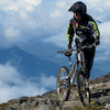
Riding AreaMount Seymour
North Vancouver, British Columbia -
Difficulty Rating
-
Trail TypeSingletrack
-
Bike TypeDH, AM
-
DirectionDownhill PrimaryPopular direction shown
-
Physical RatingHard
-
Dogs AllowedYes
-
TTFs on TrailRock Face
-
Ride in RainYes
-
Global Ranking
-
Local Popularity65 in Mountain Biking [+]
- 60 in Trail Running
- 60 in Hiking
-
Land Manager
No description for Applicator trail has been added yet! Submit one here.
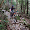
Applicator is a 499 m moderately popular black diamond singletrack trail located near North Vancouver British Columbia. This mountain bike primary trail can be used downhill primary and has a hard overall physical rating. On average it takes 8 minutes to complete this trail.
Local Trail Association
-

-

-
Please consider joining or donating to the local trail association to supportdonate to earn trail karma!
trail development & maintenance.
Traditionally Indigenous Territory
More Stats for Applicator mountain bike trail trail
-
Altitude change-159 ft
-
Altitude min719 ft
-
Altitude max899 ft
-
Altitude start878 ft
-
Altitude end719 ft
-
Grade max-61.098%
-
Grade min12.504%
-
Distance climb447 ft
-
Distance down977 ft
-
Distance flat215 ft
-
Avg time00:08:49
-
Avg reverse time00:10:15
- view trail stats
close
Trail Conditions
- Unknown
- Snow Groomed
- Snow Packed
- Snow Covered
- Snow Cover Inadequate
- Freeze/thaw Cycle
- Icy
- Prevalent Mud
- Wet
- Variable
- Ideal
- Dry
- Very Dry
Trail Flow (Ridden Direction)
Trailforks scans users ridelogs to determine the most popular direction each trail is ridden. A good flowing trail network will have most trails flowing in a single direction according to their intension.
The colour categories are based on what percentage of riders are riding a trail in its intended direction.
The colour categories are based on what percentage of riders are riding a trail in its intended direction.
- > 96%
- > 90%
- > 80%
- > 70%
- > 50%
- < 50%
- bi-directional trail
- no data
Trail Last Ridden
Trailforks scans ridelogs to determine the last time a trail was ridden.
- < 2 days
- < 1 week
- < 2 weeks
- < 1 month
- < 6 months
- > 6 months
Trail Ridden Direction
The intended direction a trail should be ridden.
- Downhill Only
- Downhill Primary
- Both Directions
- Uphill Primary
- Uphill Only
- One Direction
Contribute Details
Colors indicate trail is missing specified detail.
- Description
- Photos
- Description & Photos
- Videos
Trail Popularity ?
Trailforks scans ridelogs to determine which trails are ridden the most in the last 9 months.
Trails are compared with nearby trails in the same city region with a possible 25 colour shades.
Think of this as a heatmap, more rides = more kinetic energy = warmer colors.
- most popular
- popular
- less popular
- not popular
ATV/ORV/OHV Filter
Max Vehicle Width
inches
Radar Time
x
Activity Recordings
Trailforks users anonymized public ridelogs from the past 6 months.
- mountain biking recent
- mountain biking (>6 month)
- hiking (1 year)
- moto (1 year)
Activity Recordings
Trailforks users anonymized public skilogs from the past 12 months.
- Downhill Ski
- Backcountry Ski
- Nordic Ski
Jump Magnitude Heatmap
Heatmap of where riders jump on trails. Zoom in to see individual jumps, click circles to view jump details.
Trails Deemphasized
Trails are shown in grey.
Only show trails with NO bikes.
Save the current map location and zoom level as your default home location whenever this page is loaded.
Save
Directions to applicator trailhead
(49.332390, -122.986360)
update trails status or condition
Applicator Trail Reports
view all reports »
Recent Ridelog Activity on Trail
Past Week
- 13 rides
- 7 miles avg distance
6 Months
- 153 rides
- 8 miles avg distance
All
- 2,363 rides
Photos
more »
Trail Lists
-
 CMHC Trails35 trails
 -
Mount Seymour
57 trails
Routes with this trail
more »
Trail Products
-
+ 0
adnauseam
 (Oct 8, 2021 at 15:37)
Difficult to find. The trailhead sign is facing the wrong direction for those looking for it on the way down. The mapb doesn't show it but the first bit is a moderately technical climb peaking at a large rock. Pretty chunky going down for a few sections all in a row. A harder black trail.
[Reply]
cannae
(Sep 28, 2021 at 10:45)
I would love to ride this trail but it seems impossible to find
[Reply]
 liamdubs
Folks who rated this trail low don’t appreciate the good things in life. A short trail thats easy to session , features steep rocks and roots. Its a bundle of fun, probably treacherous in the wet. The entrance is hard to find, but its a steep technical climb from the the bottom of pussyfoot where a bunch of trails intersect.
[Reply]
corerider
(Nov 7, 2021 at 8:18)
This trail actually is one of my favourites on Seymour. I mostly push UP it to do it. Short but well worth it.
[Reply]
bboyshredder
(Sep 14, 2019 at 17:10)
Awesome trail hard to find it, but its sooooooooooo fun because its a dirt slide with two rock drops.
[Reply]
 xTwoSnakesx
Cool trail, but confusing for many reasons:
1. the map makes a short section of this trail part of the climbing route, which seems odd
2. there is an old fall line trail that follows the RR climber that has a tree at the top with a tiny sign that says "Applicator" in marker but seems to point in the opposite direction
3. there is no signage for the actual Applicator turnoff?
[Reply]
1. the map makes a short section of this trail part of the climbing route, which seems odd
2. there is an old fall line trail that follows the RR climber that has a tree at the top with a tiny sign that says "Applicator" in marker but seems to point in the opposite direction
3. there is no signage for the actual Applicator turnoff?
 KevinStafford
(Jul 8, 2018 at 14:37)
KevinStafford
(Jul 8, 2018 at 14:37)
Though short, this little trail is every bit as fun as Severed D
[Reply]
Videos
more »

7:05 |
85 |
Mar 16, 2022 , North Vancouver

1:16 |
396 |
Feb 6, 2021 , North Vancouver

3:56 |
1094 |
Mar 9, 2018 , North Vancouver

8:19 |
606 |
Mar 5, 2018 , North Vancouver
Nearby Trails
- Pussyfoot 62 ft
- Penny Lane 646 ft
- R & R Climb 820 ft
- Salamander 876 ft
- Lower C-buster 919 ft
- embed Applicator trail on your website
- By canadaka Trailforks & contributors
- #2131 - 8,452 views
- subscribe
- login to download gpx or kml files.