10.5 miles
Distance
1,859 ft
Climb
-1,863 ft
Descent
2,382 ft
High Point
A loop from the new parking lot that hits two of the best descents in Skeggs, Manzanita, and Resolution. Also includes El Corte de Madera Creek, one of the most beautiful sections of the preserve.
Detailed Description
Skeggs Figure 8 Loop is a 10 mile popular intermediate route located near Redwood City California. This mountain bike only route can be used one direction and has a moderate overall physical rating. This route includes 16 trails. This route climbs 1,859 ft with a max elevation of 2,382 ft then descends -1,863 ft.
Local Trail Association
Please consider joining or donating to the local riding association to support trail development & maintenance.
donate to earn trail karma!
-
+ 0
abarisone
 (Jun 15, 2022 at 23:46)
Trail Resolution
I am a fast rider - it’s simply not a difficult trail no matter how fast you go. Going faster makes all trains ‘harder’ but it doesn’t make all trails black rated.
[Reply]
abarisone
(Jun 3, 2022 at 20:49)
Trail Resolution
This trail should be ridden downhill direction only. There are plenty of alternate routes to take to climb out. There is absolutely no way this trail should be considered a black. Strong blue at the very most. Mix of loamy single track with a couple rocky and/or rooty technical sections. Despite the dry spell the trails are running really well and have been immaculately maintained.
[Reply]
 Kidklayko
(Jun 15, 2022 at 19:48)
Kidklayko
(Jun 15, 2022 at 19:48)
Trail Resolution
Try going faster, Resolution is the second gnarliest trail after South Leaf. I think it is more difficult than Fir to be honest because of the awkwardness and less topography it is harder to navigate without putting a foot down.
[Reply]
Kidklayko
(Mar 20, 2022 at 21:13)
Trail El Corte de Madera Creek
If you go the way suggested the beginning has a sorta jump line, it's only like 3/4 mile but fast as hell, and the climb after isn't bad. Then the downhill kicks in again, but with a flowier feel, only after you climb back out.
[Reply]
Kidklayko
(Mar 14, 2022 at 14:39)
Trail Manzanita
Can someone change this to a black, look at the voting history, also the top part of the trail between Methuselah Fire Road and Fir trail fire road, that is NOT part of the trail, it is a brief fire road that can be climbed and descended. Call it Methuselah Connector.
[Reply]
Kidklayko
(Feb 21, 2022 at 22:38)
Trail Resolution
Downhill only please, it's better, fairly techy trail, black
[Reply]
Kidklayko
(Feb 21, 2022 at 22:36)
Trail Steam Donkey
There's very little chunk on this trail compared to something like manzanita or fir trail, it's a fun little trail and Oljon to Steam Donkey makes for the perfect warmup. It's definitely a blue but the tech is super light.
[Reply]
Kidklayko
(Feb 21, 2022 at 22:30)
Trail Manzanita
Probably the best trail in the Skeggs and my go-to for a while. It's got just enough tech that the ride doesn't get boring, but it's not a double black pro-line by any means. However, I genuinely think it should be rated black since it has some tech features that might appear difficult for some beginners. It can easily be done on a hardtail as well, it's just a little more fatiguing. The tech is fairly mild, but at no point do I really get nervous with it.
[Reply]
Npeura
(Jul 14, 2021 at 20:20)
Trail Steam Donkey
Not sure how to delete my comment above, but fun trail!
[Reply]
 norbyd
(May 4, 2021 at 10:13)
norbyd
(May 4, 2021 at 10:13)
This is a great one! I think I may have fudged it and didn’t make the entire figure 8 though!
[Reply]
Wmmiller2
(Feb 14, 2021 at 11:21)
Trail Sierra Morena Trail
Lots of leaves and branches down. Wet with puddles in corners
[Reply]
Wmmiller2
(Feb 14, 2021 at 11:21)
Trail Sierra Morena Trail
Lots of leaves and branches down. Wet with puddles in corners
[Reply]
MtbSkier71
(Dec 27, 2020 at 13:02)
Trail Oljon
The upper part to Steam Donkey is fun, fun, fun. My 11 year old son developed his skills riding this to Steam Donkey (upper only) to Gordon Mill up. It's a great ~20 minute loop that isn't too technical but just enough variety to learn skills and have fun. Make some noise on blind turns since this is a well hiked trail. More experienced riders will enjoy taking this trail at speed and mastering the switchbacks.
[Reply]
MtbSkier71
(Dec 27, 2020 at 12:55)
Trail Manzanita
Should be a downhill only trail. Very bumpy ride in several sections. I won't want to do this with a hardtail as my 130mm full suspension is pushed to it's limits. There's a steep, very challenging climb up a steep rock garden to test your skills and strength. Only the best can make it on their first try!
[Reply]

 Csheu
(May 25, 2020 at 0:09)
Csheu
(May 25, 2020 at 0:09)
Trail Resolution
Tried out a demo emtb Oreba Wild FS going up Resolution and got stuck a few times and bottomed out in the rock gardens and roots, but did the entire loop in under an hour on Emtb mode. Next time will be coming down this trail!
[Reply]

MtbSkier71
(Dec 27, 2020 at 13:19)
Trail Manzanita
Although rated blue, this is by far more difficult than any other blue in the park due to the rock gardens and rocky ruts that could send someone flying. I won't take my lower intermediate riding friends on this trail. I have even had a pucker moment or two on this trail over the years when I picked a bad line (130mm travel), and I consider myself a legit advanced rider. Larger suspension bikes makes line selection not as necessary. Point is: this isn't like the other blues in the park so plan accordingly.
[Reply]
deln78
(Jul 16, 2019 at 13:13)
Trail Steam Donkey
The bottom part from Gordon Mill to Spring Board is one of the best trail segments in the park (going downhill). Chunky goodness.
[Reply]
brookelwagner
(May 24, 2019 at 8:46)
Trail Resolution
This is one of the most fun descents in the park and I really wish it was suggested as a downhill only trail.... if you are climbing Resolution, you are missing out! :-)
[Reply]
 jizgrey
(Jan 6, 2019 at 1:42)
jizgrey
(Jan 6, 2019 at 1:42)
Trail El Corte de Madera Creek
Those jumps in the picture are NOT of this trail.
[Reply]
jizgrey
(Jan 6, 2019 at 1:42)
Trail El Corte de Madera Creek
Those jumps in the picture are NOT of this trail.
[Reply]
jizgrey
(Jan 6, 2019 at 1:41)
Trail Resolution
Great trail either direction. Going in the direction suggested here, the second half is challenging, esp climbing the rock garden. Try a no-dab run.
[Reply]
jizgrey
(Jan 6, 2019 at 1:32)
Trail Steam Donkey
One of the gnarliest trails in the park. This is a one way descent in the opposite direction from what is suggested on the map here. Loose and bumpy fun.
[Reply]
 ethanromer
(Nov 6, 2017 at 17:20)
ethanromer
(Nov 6, 2017 at 17:20)
Trail El Corte de Madera Creek
Nice downhill flowy trail with jumps and a minor climb. Recommended
[Reply]
ethanromer
(Nov 6, 2017 at 17:20)
Trail El Corte de Madera Creek
Nice downhill flowy trail with jumps and a minor climb. Recommended
[Reply]
 seanmac61
(Dec 20, 2016 at 16:00)
seanmac61
(Dec 20, 2016 at 16:00)
Trail Tafoni Trail (Upper)
If you're coming from the Skeggs parking lot, I prefer this trail over the Fir Trail if you are planning on riding down Resolution or down lower Tafoni, which seems to be missing from Trail Forks. It's a little more fun and interesting, but still the width of a fire road.
[Reply]
Trails in Route
| 2 miles | |||||
| 4,511 ft | |||||
| 4,859 ft | |||||
| 2 miles | |||||
| 4,875 ft | |||||
| 1,099 ft | |||||
| 1 mile | |||||
| 1,388 ft | |||||
| 2,159 ft | |||||
| 1,532 ft | |||||
| 3,720 ft | |||||
| 203 ft | |||||
| 2,641 ft | |||||
| 2,018 ft | |||||
| 1,430 ft |
Details
-
Riding area
-
Primary ActivityMountain Bike
-
Difficulty ratingBlue
-
Route TypeLoop
-
DirectionOne Direction
-
Physical ratingModerate
-
Ridelogs
More Stats for Skeggs Figure 8 Loop mountain bike route
-
Altitude min1,628 ft
-
Altitude start2,211 ft
-
Altitude end2,208 ft
-
Grade-0%
-
Grade max-32%
-
Grade min40%
-
Distance climb5 miles
-
Distance down5 miles
-
Distance flat2,877 ft
close
Trail Conditions
- Unknown
- Snow Groomed
- Snow Packed
- Snow Covered
- Snow Cover Inadequate
- Freeze/thaw Cycle
- Icy
- Prevalent Mud
- Wet
- Variable
- Ideal
- Dry
- Very Dry
Trail Flow (Ridden Direction)
Trailforks scans users ridelogs to determine the most popular direction each trail is ridden. A good flowing trail network will have most trails flowing in a single direction according to their intension.
The colour categories are based on what percentage of riders are riding a trail in its intended direction.
The colour categories are based on what percentage of riders are riding a trail in its intended direction.
- > 96%
- > 90%
- > 80%
- > 70%
- > 50%
- < 50%
- bi-directional trail
- no data
Trail Last Ridden
Trailforks scans ridelogs to determine the last time a trail was ridden.
- < 2 days
- < 1 week
- < 2 weeks
- < 1 month
- < 6 months
- > 6 months
Trail Ridden Direction
The intended direction a trail should be ridden.
- Downhill Only
- Downhill Primary
- Both Directions
- Uphill Primary
- Uphill Only
- One Direction
Contribute Details
Colors indicate trail is missing specified detail.
- Description
- Photos
- Description & Photos
- Videos
Trail Popularity ?
Trailforks scans ridelogs to determine which trails are ridden the most in the last 9 months.
Trails are compared with nearby trails in the same city region with a possible 25 colour shades.
Think of this as a heatmap, more rides = more kinetic energy = warmer colors.
- most popular
- popular
- less popular
- not popular
ATV/ORV/OHV Filter
Max Vehicle Width
inches
Radar Time
x
Activity Recordings
Trailforks users anonymized public ridelogs from the past 6 months.
- mountain biking recent
- mountain biking (>6 month)
- hiking (1 year)
- moto (1 year)
Activity Recordings
Trailforks users anonymized public skilogs from the past 12 months.
- Downhill Ski
- Backcountry Ski
- Nordic Ski
Jump Magnitude Heatmap
Heatmap of where riders jump on trails. Zoom in to see individual jumps, click circles to view jump details.
Trails Deemphasized
Trails are shown in grey.
Only show trails with NO bikes.
Save the current map location and zoom level as your default home location whenever this page is loaded.
Save
Trail transparency
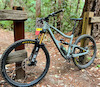
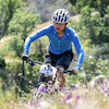
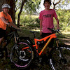
Photos
Videos


Recent Trail Reports Along Route
more reports »
- By hammersorethumb & contributors
- #22206 - 3,000 views
- login to download gpx or kml files.