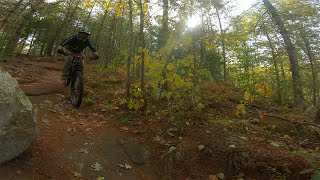
Primarily a woodland trail, the Pachaug Trail extends from Green Fall Pond in Voluntown to Pachaug Pond in Griswold. It passes ponds, streams, rock formations, travels through stands of conifers and hardwoods, and features a rhododendron sanctuary. It is almost entirely within Pachaug State Forest. There are side trails, connecting trails, and crossover trails that provide many options for further exploration. The crossover trails connect the Pachaug Trail to the Nehantic, Quinebaug, and Narragansett Trails allowing for great loop hiking opportunities.
Longer backpacking trips can be achieved by linking the Quinebaug, Pachaug, Nehantic, and Narragansett Trails. Four overnight shelters in the State Forest can be used by backpackers on a first-come, first-serve basis.
Longer backpacking trips can be achieved by linking the Quinebaug, Pachaug, Nehantic, and Narragansett Trails. Four overnight shelters in the State Forest can be used by backpackers on a first-come, first-serve basis.
- Hike
- Snowshoe
Login to see your progress towards riding all the trails in this list.
| title | riding area | rating | distance | completed | |||
|---|---|---|---|---|---|---|---|
| 1 | Green Falls Road | 82 ft | |||||
| 2 | Pachaug Trail | 2 miles | |||||
| 3 | Pachaug Trail | 1 mile | |||||
| 4 | Noah Ark Road/Pachaug Trail | 203 ft | |||||
| 5 | Beach Pond Road (165) | 1,742 ft | |||||
| 6 | Ten Road Road | 1,552 ft | |||||
| 7 | Tippecansett/Patchaug Trails | 2,228 ft | |||||
| 8 | Pachaug Trail | 1 mile | |||||
| 9 | Pachaug Trail | 1 mile | |||||
| 10 | Pachaug Trail | 2 miles | |||||
| 11 | Pachaug Trail | 2 miles | |||||
| 12 | Pachaug Trail | 358 ft | |||||
| 13 | Pachaug Trail | 2,779 ft | |||||
| 14 | Pachaug Trail | 505 ft | |||||
| 15 | Pratt Road | 2,776 ft | |||||
| 16 | Pachaug Forest Road | 3,150 ft | |||||
| 17 | Pachaug Trail | 696 ft | |||||
| 18 | Brown Road | 292 ft | |||||
| 19 | Pachaug Trail | 2 miles | |||||
| 20 | Cedar Swamp Road | 1,099 ft | |||||
| 21 | CT Route 49 | 46 ft | |||||
| 22 | Hell Hollow Road | 1,188 ft | |||||
| 23 | Pachaug Trail | 4,803 ft | |||||
| 24 | Pachaug Trail | 3 miles | |||||
| 25 | Stone Hill Road | 453 ft | |||||
| 26 | Pachaug Trail | 1 mile | |||||
| 27 | Pachaug/Nehantic Trails | 663 ft | |||||
| 28 | Trail Road 1/Pachaug/Nehantic Trails | 394 ft | |||||
| 29 | Cutoff Road/Pachaug/Nehantic Trails | 1,243 ft | |||||
| 30 | Rhododendron Sanctuary Trail | 1,257 ft | |||||
| 31 | Pachaug/Nehantic Trail | 3,691 ft | |||||
| 32 | Firetower Road | 571 ft | |||||
| 33 | Pachaug/Nehantic Trail | 2,060 ft | |||||
| 34 | Pachaug Trail | 1,798 ft | |||||
| 35 | Pachaug Trail | 1 mile | |||||
| 36 | Green Falls Road | 1,224 ft |
Displaying 36
Videos

1:53 |
147 |
Oct 12, 2020 , My City
1:53 |
151 |
Oct 5, 2020 , My City

6:50 |
174 |
Sep 23, 2020 , My City
Recent Trail Reports
| status | trail | date | condition | |
|---|---|---|---|---|
| Tippecansett/Patchaug Trails | Aug 25, 2021 @ 11:14am Aug 25, 2021 | view | ||
| Ten Road Road | Aug 25, 2021 @ 11:14am Aug 25, 2021 | view | ||
| Pachaug Trail | Aug 25, 2021 @ 11:14am Aug 25, 2021 | view | ||
| Pachaug Trail | Jun 13, 2021 @ 9:07am Jun 13, 2021 | view | ||
| Pachaug/Nehantic Trail | Jun 8, 2021 @ 7:06pm Jun 8, 2021 | view |
Total Trails
36
Total Distance
24 miles
Total Descent
-1,820 ft
Total Climb
1,796 ft
trail: Rhododendron Sanctuary Trail
6 |
Jul 10, 2021 @ 3:45pm
Jul 10, 2021
trail: Rhododendron Sanctuary Trail
7 |
Jul 10, 2021 @ 3:45pm
Jul 10, 2021
trail: Rhododendron Sanctuary Trail
19 |
Jul 10, 2021 @ 3:45pm
Jul 10, 2021
close
Trail Conditions
- Unknown
- Snow Groomed
- Snow Packed
- Snow Covered
- Snow Cover Inadequate
- Freeze/thaw Cycle
- Icy
- Prevalent Mud
- Wet
- Variable
- Ideal
- Dry
- Very Dry
Trail Flow (Ridden Direction)
Trailforks scans users ridelogs to determine the most popular direction each trail is ridden. A good flowing trail network will have most trails flowing in a single direction according to their intension.
The colour categories are based on what percentage of riders are riding a trail in its intended direction.
The colour categories are based on what percentage of riders are riding a trail in its intended direction.
- > 96%
- > 90%
- > 80%
- > 70%
- > 50%
- < 50%
- bi-directional trail
- no data
Trail Last Ridden
Trailforks scans ridelogs to determine the last time a trail was ridden.
- < 2 days
- < 1 week
- < 2 weeks
- < 1 month
- < 6 months
- > 6 months
Trail Ridden Direction
The intended direction a trail should be ridden.
- Downhill Only
- Downhill Primary
- Both Directions
- Uphill Primary
- Uphill Only
- One Direction
Contribute Details
Colors indicate trail is missing specified detail.
- Description
- Photos
- Description & Photos
- Videos
Trail Popularity ?
Trailforks scans ridelogs to determine which trails are ridden the most in the last 9 months.
Trails are compared with nearby trails in the same city region with a possible 25 colour shades.
Think of this as a heatmap, more rides = more kinetic energy = warmer colors.
- most popular
- popular
- less popular
- not popular
ATV/ORV/OHV Filter
Max Vehicle Width
inches
Radar Time
x
Activity Recordings
Trailforks users anonymized public ridelogs from the past 6 months.
- mountain biking recent
- mountain biking (>6 month)
- hiking (1 year)
- moto (1 year)
Activity Recordings
Trailforks users anonymized public skilogs from the past 12 months.
- Downhill Ski
- Backcountry Ski
- Nordic Ski
Jump Magnitude Heatmap
Heatmap of where riders jump on trails. Zoom in to see individual jumps, click circles to view jump details.
Trails Deemphasized
Trails are shown in grey.
Only show trails with NO bikes.
Save the current map location and zoom level as your default home location whenever this page is loaded.
Save
Trail transparency
This official route list of trails is not complete
Average difficulty
Mountain Bike is not supported on all trail sections of this route, see trails for more details.
Trails in Route Distance By Difficulty
Trails in Route Difficulty Totals
- By PlumbBobM
 TRAILFORKS HCH Map Team
 - #669 - 221 views