The West Highland Way (Scottish Gaelic: Slighe na Gàidhealtachd an Iar) is a linear long distance footpath in Scotland, with the official status of Long Distance Route. It is 154.5 km (96.0 mi) long, running from Milngavie north of Glasgow to Fort William in the Scottish Highlands.
https://www.westhighlandway.org/
https://www.westhighlandway.org/
- Mountain Bike
- E-Bike
- Hike
- Trail Running
Login to see your progress towards riding all the trails in this list.
Displaying 58
Videos
youtuber
![The Ciaran Path By Mountain Bike]()

19:30 |
152 |
Sep 13, 2020 , Glencoe

11:19 |
490 |
Jul 26, 2020 , Glencoe
11:19 |
211 |
Jul 26, 2020 , Glencoe
Recent Trail Reports
| status | trail | date | condition | |
|---|---|---|---|---|
| Access Road (WHW-6) | Jun 9, 2022 @ 1:10am Jun 9, 2022 | view | ||
| West Highland Way (WHW-2) | Feb 19, 2022 @ 7:29am Feb 19, 2022 | view | ||
| Conic Hill Descent (WHW-9) | Oct 15, 2021 @ 6:28am Oct 15, 2021 | view | ||
| Down the Steps (WHW-9) | Oct 15, 2021 @ 6:28am Oct 15, 2021 | view | ||
| Access Track (WHW-48) | May 22, 2021 @ 3:24am May 22, 2021 | view |
Total Trails
58
Total Distance
98 miles
Total Descent
-10,097 ft
Total Climb
12,070 ft
trail: West Highland Way (WHW-3)
380 |
Nov 18, 2020 @ 1:43am
Nov 18, 2020
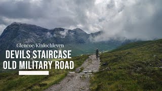
trail: Devil's Staircase (WHW-46)
97 |
Aug 30, 2020 @ 9:53am
Aug 30, 2020
trail: Devil's Staircase (WHW-46)
348 |
Jun 11, 2010 @ 3:19pm
Jun 11, 2010
close
Trail Conditions
- Unknown
- Snow Groomed
- Snow Packed
- Snow Covered
- Snow Cover Inadequate
- Freeze/thaw Cycle
- Icy
- Prevalent Mud
- Wet
- Variable
- Ideal
- Dry
- Very Dry
Trail Flow (Ridden Direction)
Trailforks scans users ridelogs to determine the most popular direction each trail is ridden. A good flowing trail network will have most trails flowing in a single direction according to their intension.
The colour categories are based on what percentage of riders are riding a trail in its intended direction.
The colour categories are based on what percentage of riders are riding a trail in its intended direction.
- > 96%
- > 90%
- > 80%
- > 70%
- > 50%
- < 50%
- bi-directional trail
- no data
Trail Last Ridden
Trailforks scans ridelogs to determine the last time a trail was ridden.
- < 2 days
- < 1 week
- < 2 weeks
- < 1 month
- < 6 months
- > 6 months
Trail Ridden Direction
The intended direction a trail should be ridden.
- Downhill Only
- Downhill Primary
- Both Directions
- Uphill Primary
- Uphill Only
- One Direction
Contribute Details
Colors indicate trail is missing specified detail.
- Description
- Photos
- Description & Photos
- Videos
Trail Popularity ?
Trailforks scans ridelogs to determine which trails are ridden the most in the last 9 months.
Trails are compared with nearby trails in the same city region with a possible 25 colour shades.
Think of this as a heatmap, more rides = more kinetic energy = warmer colors.
- most popular
- popular
- less popular
- not popular
ATV/ORV/OHV Filter
Max Vehicle Width
inches
Radar Time
x
Activity Recordings
Trailforks users anonymized public ridelogs from the past 6 months.
- mountain biking recent
- mountain biking (>6 month)
- hiking (1 year)
- moto (1 year)
Activity Recordings
Trailforks users anonymized public skilogs from the past 12 months.
- Downhill Ski
- Backcountry Ski
- Nordic Ski
Jump Magnitude Heatmap
Heatmap of where riders jump on trails. Zoom in to see individual jumps, click circles to view jump details.
Trails Deemphasized
Trails are shown in grey.
Only show trails with NO bikes.
Save the current map location and zoom level as your default home location whenever this page is loaded.
Save
Trail transparency
This official route list of trails is not complete
Average difficulty
Associated Route
Mountain Bike is not supported on all trail sections of this route, see trails for more details.
Trails in Route Distance By Difficulty
Trails in Route Difficulty Totals
- By canadaka
 Trailforks
 - #768 - 391 views