3,688 ft
Distance
-733 ft
Descent
00:06:54
Avg time
Supporters, Builders, Maintainers & Land Managers of Angry M Trail

Stark Architects
since 2019Sponsor
Clark LewisBuilder
Angry M Details
-
Activities
- Mountain Bike
- E-Bike
-
Riding AreaDiamond Head
Squamish, British Columbia -
Difficulty Rating
-
Voted DifficultyBlack Diamond (2 votes)
-
Trail TypeSingletrack
-
Bike TypeDH, AM
-
DirectionDownhill OnlyPopular direction shown
-
Dogs AllowedYes
-
eBike AllowedYes up to Class 1
-
TTFs on TrailBerm, Bridge, Ladder Bridge
-
Global Ranking
-
Local Popularity100 in Mountain Biking [+]
- 100 in E-Biking
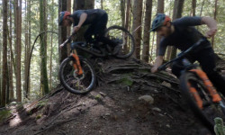
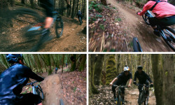
Intermediate trail that flows and winds on a loamy tread through the forest passing over half nelson. No big features here, just the occasional ladders crossing drainages and the ever-present root challenges
Access Info
Accessed by riding up Ring Creek road and continuing past Half Nelson.
Local Trail Association
-

-
Please consider joining or donating to the local trail association to supportdonate to earn trail karma!
trail development & maintenance.
Traditionally Indigenous Territory
More Stats for Angry M mountain bike trail trail
-
Altitude change-733 ft
-
Altitude min1,241 ft
-
Altitude max1,974 ft
-
Altitude start1,974 ft
-
Altitude end1,240 ft
-
Grade-19.9%
-
Grade max-46.3%
-
Grade min-9.1%
-
Distance down3,688 ft
-
Avg time00:06:54
-
Avg reverse time00:10:19
- view trail stats
close
Trail Conditions
- Unknown
- Snow Groomed
- Snow Packed
- Snow Covered
- Snow Cover Inadequate
- Freeze/thaw Cycle
- Icy
- Prevalent Mud
- Wet
- Variable
- Ideal
- Dry
- Very Dry
Trail Flow (Ridden Direction)
Trailforks scans users ridelogs to determine the most popular direction each trail is ridden. A good flowing trail network will have most trails flowing in a single direction according to their intension.
The colour categories are based on what percentage of riders are riding a trail in its intended direction.
The colour categories are based on what percentage of riders are riding a trail in its intended direction.
- > 96%
- > 90%
- > 80%
- > 70%
- > 50%
- < 50%
- bi-directional trail
- no data
Trail Last Ridden
Trailforks scans ridelogs to determine the last time a trail was ridden.
- < 2 days
- < 1 week
- < 2 weeks
- < 1 month
- < 6 months
- > 6 months
Trail Ridden Direction
The intended direction a trail should be ridden.
- Downhill Only
- Downhill Primary
- Both Directions
- Uphill Primary
- Uphill Only
- One Direction
Contribute Details
Colors indicate trail is missing specified detail.
- Description
- Photos
- Description & Photos
- Videos
Trail Popularity ?
Trailforks scans ridelogs to determine which trails are ridden the most in the last 9 months.
Trails are compared with nearby trails in the same city region with a possible 25 colour shades.
Think of this as a heatmap, more rides = more kinetic energy = warmer colors.
- most popular
- popular
- less popular
- not popular
ATV/ORV/OHV Filter
Max Vehicle Width
inches
Radar Time
x
Activity Recordings
Trailforks users anonymized public ridelogs from the past 6 months.
- mountain biking recent
- mountain biking (>6 month)
- hiking (1 year)
- moto (1 year)
Activity Recordings
Trailforks users anonymized public skilogs from the past 12 months.
- Downhill Ski
- Backcountry Ski
- Nordic Ski
Jump Magnitude Heatmap
Heatmap of where riders jump on trails. Zoom in to see individual jumps, click circles to view jump details.
Trails Deemphasized
Trails are shown in grey.
Only show trails with NO bikes.
Save the current map location and zoom level as your default home location whenever this page is loaded.
Save
Directions to angry-m trailhead
(49.743930, -123.060850)
 Articles
Video: Jesse Melamed Shows You The Racing Line on Squamish's 'Angry Midget'
May 12, 2020 from pinkbike.com
A full breakdown of all the key sections and their time differences.
Video: Richie Rude vs. The OneUp Office
Aug 22, 2019 from pinkbike.com
Starting at the back of the pack, can Richie pass and beat the whole office?
update trails status or condition
Angry M Trail Reports
view all reports »
Recent Ridelog Activity on Trail
Past Week
- 58 rides
- 10 miles avg distance
6 Months
- 1,499 rides
- 11 miles avg distance
All
- 11,045 rides
Technical Trail Features (TTF)
- Bridge
 Bridge
 - Bridge over half nelson Ladder Bridge
Photos
more »
Trail Lists
-
bms
28 trails
-
Squamish - Diamond Head
11 trails
-
TBS Diamond Head
6 trails
-
Wishlist
10 trails
-
GMBN LIST
3 trails
-
Squamish Diamond Head
17 trails
-
SORCA 29 Trails
29 trails
Routes with this trail
more »
Trail Products
-
 SORCA Trail SupporterTrail Pass
Pinkbike Articles
May 12, 2020
 Video: Jesse Melamed Shows You The Racing Line on Squamish's 'Angry Midget'
A full breakdown of all the key sections and their time differences.
Aug 22, 2019
 Video: Richie Rude vs. The OneUp Office
Starting at the back of the pack, can Richie pass and beat the whole office?
Oct 31, 2021
 Video: Mind the Brain - The Science of 'Everesting'
"If the body won’t quit until the mind does, I had to set a higher threshold for my mind."
-
+ 1
 liamdubs
Running great even after the rain this week. Lots of fun!
[Reply]

nash89
(Jul 28, 2019 at 22:11)
Couldn’t mind angry midget, somehow the trail had vanished. So rode this instead. Not as good as angry midget!!!
[Reply]
 blanshard16
I re-routed the GPS track as it was showing Angry finishing via the connector into DP - which barely gets used except by those afraid of rocks!
[Reply]
Jase-the-ace
 (Aug 25, 2018 at 11:53)
Steep, rutted, not much flow. There were some nice loamy sections switchbacking down the middle section, but everyone seems to just straight line it down and miss these out
[Reply]
 blackcombterry
A fun descent and a great option to add into longer loops. Difficulty level is be dark blue/light black.
[Reply]
Videos
more »


Nearby Trails
- Climb Trail - Stl'lhalem Sintl' (upper) 325 ft
- Upper Half Nelson 413 ft
- One Man's Garbage 719 ft
- Ditch Pig 1,263 ft
- Recycle 2,425 ft
- embed Angry M trail on your website
- By chaynech1 & contributors
- #1270 - 32,859 views
- subscribe
- login to download gpx or kml files.