close
Trail Conditions
- Unknown
- Snow Groomed
- Snow Packed
- Snow Covered
- Snow Cover Inadequate
- Freeze/thaw Cycle
- Icy
- Prevalent Mud
- Wet
- Variable
- Ideal
- Dry
- Very Dry
Trail Flow (Ridden Direction)
Trailforks scans users ridelogs to determine the most popular direction each trail is ridden. A good flowing trail network will have most trails flowing in a single direction according to their intension.
The colour categories are based on what percentage of riders are riding a trail in its intended direction.
The colour categories are based on what percentage of riders are riding a trail in its intended direction.
- > 96%
- > 90%
- > 80%
- > 70%
- > 50%
- < 50%
- bi-directional trail
- no data
Trail Last Ridden
Trailforks scans ridelogs to determine the last time a trail was ridden.
- < 2 days
- < 1 week
- < 2 weeks
- < 1 month
- < 6 months
- > 6 months
Trail Ridden Direction
The intended direction a trail should be ridden.
- Downhill Only
- Downhill Primary
- Both Directions
- Uphill Primary
- Uphill Only
- One Direction
Contribute Details
Colors indicate trail is missing specified detail.
- Description
- Photos
- Description & Photos
- Videos
Trail Popularity ?
Trailforks scans ridelogs to determine which trails are ridden the most in the last 9 months.
Trails are compared with nearby trails in the same city region with a possible 25 colour shades.
Think of this as a heatmap, more rides = more kinetic energy = warmer colors.
- most popular
- popular
- less popular
- not popular
ATV/ORV/OHV Filter
Max Vehicle Width
inches
Radar Time
x
Activity Recordings
Trailforks users anonymized public ridelogs from the past 6 months.
- mountain biking recent
- mountain biking (>6 month)
- hiking (1 year)
- moto (1 year)
Activity Recordings
Trailforks users anonymized public skilogs from the past 12 months.
- Downhill Ski
- Backcountry Ski
- Nordic Ski
Jump Magnitude Heatmap
Heatmap of where riders jump on trails. Zoom in to see individual jumps, click circles to view jump details.
Trails Deemphasized
Trails are shown in grey.
Only show trails with NO bikes.
Save the current map location and zoom level as your default home location whenever this page is loaded.
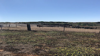
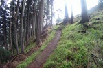
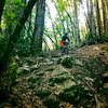
SaveThe trails of Tilden and Wildcat are best known for their views, as opposed to optimum riding. Located in the hills above densely populated urban areas, these trails see heavy use from cyclists, joggers, dog walkers, and hikers. In parts of the area, you'll also encounter cows, peacefully grazing the hillsides.
Most of the trails are fire roads, wide and rocky. From the hilltops you'll get amazing views of the San Francisco Bay Area on one side and you'll see nice vistas to the east as well.
Most of the trails are fire roads, wide and rocky. From the hilltops you'll get amazing views of the San Francisco Bay Area on one side and you'll see nice vistas to the east as well.
 google parking directions
 Activities Click to view
- Mountain Bike
48 trails
- E-Bike
1 trails
- Hike
65 trails
- Trail Running
65 trails
- Horse
8 trails
Region Details
- 5
- 2
- 11
- 28
- 2
Region Status
Caution as of Jun 6, 2022Stats
- Avg Trail Rating
- Trails (view details)
- 66
- Trails Mountain Bike
- 48
- Trails E-Bike
- 1
- Trails Hike
- 65
- Trails Trail Running
- 65
- Trails Horse
- 8
- Total Distance
- 68 miles
- Total Descent
- 17,283 ft
- Total Vertical
- 1,711 ft
- Highest Trailhead
- 1,915 ft
- Reports
- 350
- Photos
- 98
- Ridden Counter
- 5,948
Popular Tilden and Wildcat Canyon Trails
Mountain Bike Routes
| title | rating | distance |
|---|---|---|
| BTCEB B- Tilden Gala Ride | 9 miles | |
| The whole shebang | 32 miles | |
| Tilden Loops | 20 miles |
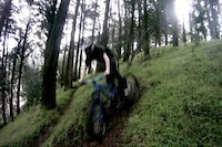
Photos of Tilden and Wildcat Canyon Mountain Bike
trail: Stables
11 |
Jun 1, 2022 @ 5:56pm
Jun 1, 2022
trail: Fenceline
43 |
Jan 19, 2022 @ 11:48am
Jan 19, 2022
trail: Fenceline
47 |
Jan 19, 2022 @ 11:48am
Jan 19, 2022
trail: Fenceline
33 |
Jan 19, 2022 @ 11:48am
Jan 19, 2022
trail: Fenceline
38 |
Jan 19, 2022 @ 11:48am
Jan 19, 2022
trail: Havey Canyon Trail
53 |
Sep 29, 2021 @ 10:14am
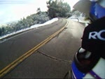
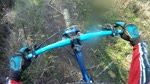
Sep 29, 2021Videos of Tilden and Wildcat Canyon Mountain Bike
trail: Beyond Nimitz
|
Jul 23, 2021

trail: Stables
307 |
Apr 20, 2021

0:59 |
351 |
Oct 16, 2011
2:18 |
3181 |
May 2, 2011
7:33 |
651 |
Mar 16, 2011
8:04 |
769 |
Jan 24, 2011
3:18 |
550 |
Jan 18, 2011

12:09 |
58 |
Nov 24, 2020
Current Trail Warnings
| status | trail | date | condition | user | info |
|---|---|---|---|---|---|
| Lower Big Springs Trail | Jul 1, 2022 @ 9:59am Jul 1, 2022 | Ideal | jamuel BTCEB | Tree down as was already reported. Amber... | |
| Aqua Vista Trail | Jun 20, 2022 @ 12:20pm Jun 20, 2022 | Dry | mtbflauto | Beehive right next to the trail close to... |
Recent Trail Reports
| status | trail | date | condition | info | user |
|---|---|---|---|---|---|
| Vollmer Peak Trail | Jul 1, 2022 @ 9:59am Jul 1, 2022 | Ideal | jamuel BTCEB | ||
| Stables | Jun 29, 2022 @ 10:39am Jun 29, 2022 | Very Dry | berkeleybiker | ||
| Side-O | Jun 29, 2022 @ 10:39am Jun 29, 2022 | Very Dry | berkeleybiker | ||
| Wildcat Creek Trail | Jun 24, 2022 @ 5:13pm Jun 24, 2022 | Ideal | jvsabas | ||
| Meadows Canyon Trail | Jun 24, 2022 @ 5:13pm Jun 24, 2022 | Dry | jvsabas | ||
| Nimitz Way | Jun 24, 2022 @ 5:13pm Jun 24, 2022 | Ideal | jvsabas | ||
| Mezue Trail | Jun 24, 2022 @ 5:13pm Jun 24, 2022 | Dry | jvsabas | ||
| Curran Trail | Jun 2, 2022 @ 2:28pm Jun 2, 2022 | Ideal | AlanDixonK5 | ||
| San Pablo Ridge Trail | May 23, 2022 @ 1:23pm May 23, 2022 | Dry | AlanDixonK5 | ||
| Havey Canyon Trail | May 23, 2022 @ 1:22pm May 23, 2022 | Ideal | AlanDixonK5 |
Activity Feed
| username | action | type | title | date | |
|---|---|---|---|---|---|
 | jamuel | add | report | Vollmer Peak Trail and 1 more | Jul 1, 2022 @ 1:34pm Jul 1, 2022 |
| Candersonway | add | report | Lower Big Springs Trail | Jun 30, 2022 @ 6:03pm Jun 30, 2022 |
| berkeleybiker | add | report | Stables and 1 more | Jun 29, 2022 @ 2:19pm Jun 29, 2022 |
| nfruit | difficultyvote | trail | Wildcat Gorge Trail and 3 more | Jun 27, 2022 @ 11:36am Jun 27, 2022 |
 | jvsabas | add | report | Wildcat Creek Trail and 3 more | Jun 25, 2022 @ 10:32am Jun 25, 2022 |
Recent Comments
| username | type | title | comment | date | |
|---|---|---|---|---|---|
 | trail | This is a completely blown out cattle trail,... | Jan 28, 2022 @ 6:34pm Jan 28, 2022 | ||
 | trail | Anyone else having trouble getting this trail... | Jul 25, 2021 @ 12:36pm Jul 25, 2021 | ||
| report | I appreciate the wild ride that you had on... | Jun 17, 2021 @ 3:31pm Jun 17, 2021 | ||
| trail | Tough challenge as a climb, or a short rocky... | Mar 5, 2021 @ 9:38am Mar 5, 2021 | ||
| trail | Gorge trail becomes illegal to bikes after... | Feb 5, 2021 @ 9:06am Feb 5, 2021 |
Nearby Areas
| name | distance | ||||
|---|---|---|---|---|---|
| Kennedy Grove Regional Recreation Area | 2 | 3.3 km | |||
| Sibley Volcanic Regional Preserve | 2 | 4.2 km | |||
| East Bay Waterfront | 3 | 4.2 km | |||
| Sobrante Ridge Regional Preserve | 1 | 3 | 4.6 km | ||
| Alvarado Park | 1 | 2 | 1 | 5.2 km |
Local Badges
-

Completionist1 awarded
Local Mountain Biking Directory
-
Bicycle Trails Council of the East Bay
![Bicycle Trails Council of the East Bay]()
-
Teen Trail Corps
![Teen Trail Corps]()
-
Wrench ScienceBike Shop
-
Mike's Bikes - BerkeleyBike Shop
-
Missing Link Bicycle Co-opBike Shop
-
Peter Richs Velo SportBike Shop
Activity Type Stats
| activitytype | trails | distance | descent | descent distance | total vertical | rating | global rank | state rank | photos | reports | routes | ridelogs |
|---|---|---|---|---|---|---|---|---|---|---|---|---|
| Mountain Bike | 48 | 44 miles | 10,089 ft | 25 miles | 1,693 ft | #1,025 | #537 | 98 | 350 | 3 | 10,545 | |
| E-Bike | 1 | 988 ft | 72 ft | 853 ft | 72 ft | #1,249 | 284 | 1 | 136 | |||
| Hike | 65 | 68 miles | 17,201 ft | 39 miles | 1,713 ft | #781 | #471 | 350 | 561 | |||
| Trail Running | 65 | 68 miles | 17,201 ft | 39 miles | 1,713 ft | #786 | #469 | 350 | 435 | |||
| Horse | 8 | 11 miles | 2,290 ft | 5 miles | 1,316 ft | #183 | #131 | 23 |
- By brenthillier
 NSMBA TRAILFORKS & contributors
 - Admins: BTCEB, sanfret
- #8290 - 7,050 views
- tilden and wildcat canyon activity log | embed map of Tilden and Wildcat Canyon mountain bike trails | tilden and wildcat canyon mountain biking points of interest
Downloading of trail gps tracks in kml & gpx formats is enabled for Tilden and Wildcat Canyon.
You must login to download files.